File:LibyanRepublicRelations.svg
Ir a la navegación
Ir a la búsqueda

Tamaño de esta previsualización PNG del archivo SVG: 800 × 395 píxeles. Otras resoluciones: 320 × 158 píxeles | 640 × 316 píxeles | 1024 × 506 píxeles | 1280 × 633 píxeles | 2560 × 1265 píxeles | 880 × 435 píxeles.
Archivo original (archivo SVG, nominalmente 880 × 435 píxeles, tamaño de archivo: 1,3 MB)
Leyendas
Leyendas
Añade una explicación corta acerca de lo que representa este archivo
Resumen[editar]
| Descripción |
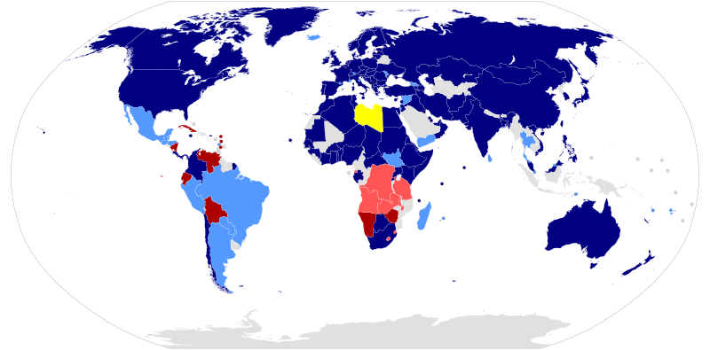
Հայերեն: Աշխարհի ընդհանուր քարտեզ, որը ցույց է տալիս այն երկրները, որոնք ճանաչել կամ ոչ պաշտոնական հարաբերություններ են ունեցել Լիբիայի Հանրապետության հետ 2011թ. քաղաքացիական պատերազմի ընթացքում:
Լիբիա
Երկրներ որը ճանաչում էին ներկա գտնվող պետությունը որպեսզի միայն պետությունը Լիբիայում:
Երկրներ որը հարաբերություններ ունեին կամ ճանաչում էին Լիբիաի ներկա գտնվող պետությանը Միավորված Ազգերի Կազմարկերպությանում, բայծ հրապարակավ չեն հայտնել:
Երկրներ որը չէին ճանաչում Լիբիաի ներկա գտնվող պետությունը, բայց հրապարակավ չեն հայտնել:
Երկրներ որը չէին ճանաչում Լիբիաի ներկա գտնվող պետությունը: Español: Mapamundi de las relaciones diplomáticas que otros países mantuvieron con el Consejo Nacional de Transición de Libia durante la Guerra Civil de 2011.
Libia
Países que reconocieron al Consejo Nacional de Transición (CNT) como el único y legítimo representante de Libia.
Países favorables al CNT, o que votaron a favor de su reconocimiento en Naciones Unidas, pero que no otorgaron su aprobación propia de manera oficial.
Países contrarios al CNT, aunque no de manera oficial o púbica.
Países que no reconocieron al CNT. Deutsch: Eine Weltkarte, die Staaten zeigt, welche den Nationalen Übergangsrat anerkennen oder informelle Beziehungen zu diesem haben.
Libyen
Staaten, die den Nationalen Übergangsrat als einzige legitime Vertretung des libyschen Volkes anerkannt haben
Staaten, die einen permanenten diplomatischen Vertreter zum Übergangsrat entsandt haben, ohne diesen formal anzuerkennen
Staaten, die die Anerkennung des Nationalen Übergangsrats bei den Vereinten Nationen ablehnen, jedoch keine formelle Erklärung abgaben.
Staaten, die die Anerkennung des Übergangsrats verweigern English: A global map of the world showing countries that recognized or had informal relations with the Libyan Republic during the civil war of 2011.
Libya
Countries that recognised the National Transitional Council (NTC) as the sole legitimate representative of Libya
Countries that had permanent informal relations with the NTC, or which voted in favor of recognition at the UN, but had not granted official recognition
Countries which opposed recognition of the NTC at the UN, but had not made a formal statement
Countries that said they would not recognise the NTC Français : Une carte du monde représentant les pays ayant reconnu ou ayant des relations avec le w:Conseil National de Transition.
Libye
Pays ayant reconnu le w:Conseil National de Transition comme seul représentation légitime de la Libye
Pays ayant des relations avec Benghazi mais n'ayant pas officiellement reconnu le CNT
Pays s'opposant à la reconnaissance du CNT par l'ONU sans avoir pris position officiellement.
Pays déclarant officiellement ne pas reconnaître le w:Conseil National de Transition Македонски: Карта на државите во светот според воспоставените дипломатски односи со Либија.
Либија
Држави кои го признале Националниот транзициски совет како лигитимно тело на Либија.
Држави кои оствариле дипломатски односи со Бенгази, но немаат формални официјални односни.
Држави кои се спротивставиле на признавањето на НТС во ООН.
Држави кои не го признаваат Националниот транзициски совет. Nederlands: Een wereldkaart die staten toont die de Nationale Overgangsraad erkennen of er informele betrekkingen mee onderhouden.
Libië
Staten die de Nationale Overgangsraad als enige wettige vertegenwoordiger van het Libische volk hebben erkend
Staten die een permanente diplomatieke vertegenwoordiger naar de Overgangsraad hebben gestuurd zonder deze formeel te erkennen
Landen, die geprotesteerd hebben tegen de erkenning van de NOR bij de VN Staten die hebben aangegeven de Overgangsraad niet te zullen erkennen Português: Mapa-mundi mostrando as relações internacionais do w:Conselho Nacional de Transição da w:Líbia
Líbia
Países que reconheceram o Conselho Nacional de Transição como o único e legítimo representante da Líbia
Países que ainda não declararam reconhecimento oficial mas votaram a favor do CNT na ONU
Países que votaram contra o CNT na ONU mas ainda não se declararam a respeito de sua legitimidade
Países que declararam ser contra o CNT Română: O hartă a lumii reprezentând țările ce au recunoscut Consiliul Național de Tranziție ca reprezentantul legitim al poporului libian.
Libia
Țări ce au recunoscut Consiliul Național de Tranziție ca reprezentantul legitim al Libiei
Țări ce au legături informale cu Consiliul Național de Tranziție sau au votat în favoare recunoașterii la ONU fără a avea relații oficiale
Țări ce s-au opus recunoașterii la votul ONU, dar care nu au emis o declarație oficială
Țări ce susțin că nu vor recunoaște Consiliul Național de Tranziție Русский: Карта мира со странами, которые признают или имеют неформальные отношения с НПС Ливии.
Ливия
Страны, которые признали НПС в качестве единственного законного представителя Ливии
Страны, которые имеют постоянные неформальные отношения с НПС, но еще не утвердили официальное признание
Other countries which opposed recognition of the NTC at the UN
Страны, которые заявили, что не будут признавать НПС Türkçe: Libya Cumhuriyeti ile resmi veya gayri resmi ilişkileri olan ülkelerin dünya haritası.
Libya
Geçici Ulusal Konseyi'ni Libya'nın tek meşru temsilcisi olarak kabul etmiş ülkeler
Bingazi ile kalıcı gayri resmi ilişkisi olan ama resmen tanımayan ülkeler
Other countries which opposed recognition of the NTC at the UN
GUK'u tanımayacağını belirten ülkeler 中文:地图示意正式或非正式承认利比亚全国过渡委员会的国家或地区.
利比亚
正式承认全国过渡委员会为利比亚合法政权
非正式承认但与全国过渡委员会有联系的国家
其他反对联合国承认全国过渡委员会的国家
不会承认全国过渡委员会的国家 日本語: リビア国民評議会に対する各国の認識を示した世界地図。
リビア
リビアの唯一の正当な政府としてリビア国民評議会を承認している国
リビア国民評議会と恒久的な非公式の関係を持っていた国、または国連で承認に賛成したが、正式な承認は与えていない国
リビアの唯一の正統な政府としてリビア国民評議会を承認しないとしている国
国連で承認に反対したが、正式な声明を発表していない国 |
| Fuente |
File:BlankMap-World-Microstates.svg |
| Autor | Various (see below) |
Licencia[editar]
| Yo, el titular de los derechos de autor de esta obra, lo libero al dominio público. Esto aplica en todo el mundo. En algunos países esto puede no ser legalmente factible; si ello ocurriese: Concedo a cualquier persona el derecho de usar este trabajo para cualquier propósito, sin ningún tipo de condición al menos que éstas sean requeridas por la ley. |
Registro original de carga[editar]
Aquí se muestra la página de descripción original. Los siguientes nombres de usuario se refieren a en.wikipedia.
Upload date | User | Bytes | Dimensions | Comment
- 2011-08-16 00:49:44 | Haha169 | 1458104 | 880×435 | Don't know how China got left out. Simply following the table in the article, its got the same designation as Egypt, Greece, etc.,
- 2011-08-14 16:30:31 | U5K0 | 1458046 | 880×435 | sorry. my bad
- 2011-08-14 16:15:33 | U5K0 | 1462776 | 880×435 | Gabon as per countries table in the article
- 2011-08-12 23:53:26 | U5K0 | 1459143 | 880×435 | Botswana as per article and reference in article - see table with countries
- 2011-08-11 14:05:16 | Brightgalrs | 1457980 | 880×435 | Tweaked Sudan-South Sudan border (made it more visible)
- 2011-08-06 21:58:48 | Brightgalrs | 1457922 | 880×435 | Switched Kosovo and Montenegro's color. (Thanks Yalens)
- 2011-08-04 23:46:07 | Brightgalrs | 1457784 | 880×435 | Czech republic light blue Kosovo added back in (why did I delete this again?) as dark blue dot
- 2011-07-29 23:15:03 | U5K0 | 1456236 | 880×435 | portugal to dark blue as per talk page article
- 2011-07-21 16:03:28 | Brightgalrs | 1457158 | 880×435 | Montenegro
- 2011-07-20 18:18:56 | Brightgalrs | 1457086 | 880×435 | Added a grey dot for the Republic of Kosovo.
- 2011-07-20 17:34:23 | U5K0 | 1456212 | 880×435 | Slovenia recognises NTC as per http://www.mzz.gov.si/nc/si/splosno/cns/novica/article/6/29268/47f4795180/
- 2011-07-18 13:38:54 | Brightgalrs | 1455857 | 880×435 | Albania recognizes the NTC http://www.ora-news.com/v2/index.php?on=details&id=22692&nid=1&PHPSESSID=5d613e9758ecb4b261a2ea894f935fc4
- 2011-07-17 04:50:09 | Brightgalrs | 1455841 | 880×435 | South Sudan, resized
- 2011-07-17 04:05:44 | Brightgalrs | 1452050 | 940×477 | And I forgot Malta.
- 2011-07-17 04:03:51 | Brightgalrs | 1451955 | 940×477 | Added various dependencies of the USA, UK, Netherlands and France.
- 2011-07-16 18:53:29 | Brightgalrs | 1444235 | 940×477 | Forgot Senegal, good catch.
- 2011-07-16 02:24:34 | Brightgalrs | 1444231 | 940×477 | {{Information |Description = {{en|1=A global map of the world showing countries that recognize or have informal relations with the [[Libyan Republic]]}} |Source = [[:File:BlankMap-World-Microstates.svg]]<br>{{Inkscape}} |Date = ~~~
Historial del archivo
Haz clic sobre una fecha y hora para ver el archivo tal como apareció en ese momento.
| Fecha y hora | Miniatura | Dimensiones | Usuario | Comentario | |
|---|---|---|---|---|---|
| actual | 19:31 7 dic 2011 | | 880 × 435 (1,3 MB) | Raistuumum (discusión | contribs.) | Mauritania and Eritrea to dark blue |
| 22:23 21 oct 2011 |  | 880 × 435 (1,3 MB) | StalwartUK (discusión | contribs.) | background fixed - again | |
| 18:48 20 oct 2011 |  | 880 × 435 (1,3 MB) | Kudzu1 (discusión | contribs.) | Vatican City to dark blue. This is a pretty borderline change, seeing as that hostilities have effectively been concluded. After Abdul Jalil issues the declaration of liberation, I'm going to consider the war to be over and I'm going to stop updating this | |
| 16:06 20 oct 2011 |  | 880 × 435 (1,3 MB) | StalwartUK (discusión | contribs.) | fixed the background | |
| 14:04 16 oct 2011 |  | 880 × 435 (1,3 MB) | Kudzu1 (discusión | contribs.) | Pakistan to dark blue | |
| 23:35 14 oct 2011 |  | 880 × 435 (1,3 MB) | Kudzu1 (discusión | contribs.) | Bangladesh to dark blue | |
| 17:14 1 oct 2011 |  | 880 × 435 (1,3 MB) | Kudzu1 (discusión | contribs.) | Namibia to dark red | |
| 15:01 1 oct 2011 |  | 880 × 435 (1,3 MB) | Kudzu1 (discusión | contribs.) | Jamaica to dark blue | |
| 00:50 1 oct 2011 |  | 880 × 435 (1,3 MB) | Kudzu1 (discusión | contribs.) | Switzerland, Uganda, Somalia to dark blue | |
| 19:36 29 sep 2011 |  | 880 × 435 (1,3 MB) | Kudzu1 (discusión | contribs.) | Mauritius to light blue, and I think it's best to follow the lead of other maps and leave W. Sahara uncolored |
No puedes sobrescribir este archivo.
Usos del archivo
Las siguientes páginas usan este archivo:
Uso global del archivo
Las wikis siguientes utilizan este archivo:
- Uso en ar.wikipedia.org
- Uso en ast.wikipedia.org
- Uso en de.wikipedia.org
- Uso en de.wikinews.org
- Uso en en.wikipedia.org
- Uso en es.wikipedia.org
- Uso en fa.wikipedia.org
- Uso en fr.wikipedia.org
- Uso en he.wikipedia.org
- Uso en hu.wikipedia.org
- Uso en ja.wikipedia.org
- Uso en lt.wikipedia.org
- Uso en nl.wikipedia.org
- Uso en pl.wikipedia.org
- Uso en pt.wikipedia.org
- Uso en ro.wikipedia.org
- Uso en ru.wikipedia.org
- Uso en ta.wikipedia.org
- Uso en tr.wikipedia.org
- Uso en vi.wikipedia.org
- Uso en zh.wikipedia.org