File:Little Hocking River map.png
跳至導覽
跳至搜尋
預覽大小:697 × 600 像素。 其他解析度:279 × 240 像素 | 558 × 480 像素 | 892 × 768 像素 | 1,190 × 1,024 像素 | 2,380 × 2,048 像素 | 2,763 × 2,378 像素。
原始檔案 (2,763 × 2,378 像素,檔案大小:6.99 MB,MIME 類型:image/png)
說明
說明
添加單行說明來描述出檔案所代表的內容
摘要
[編輯]
| 描述 |
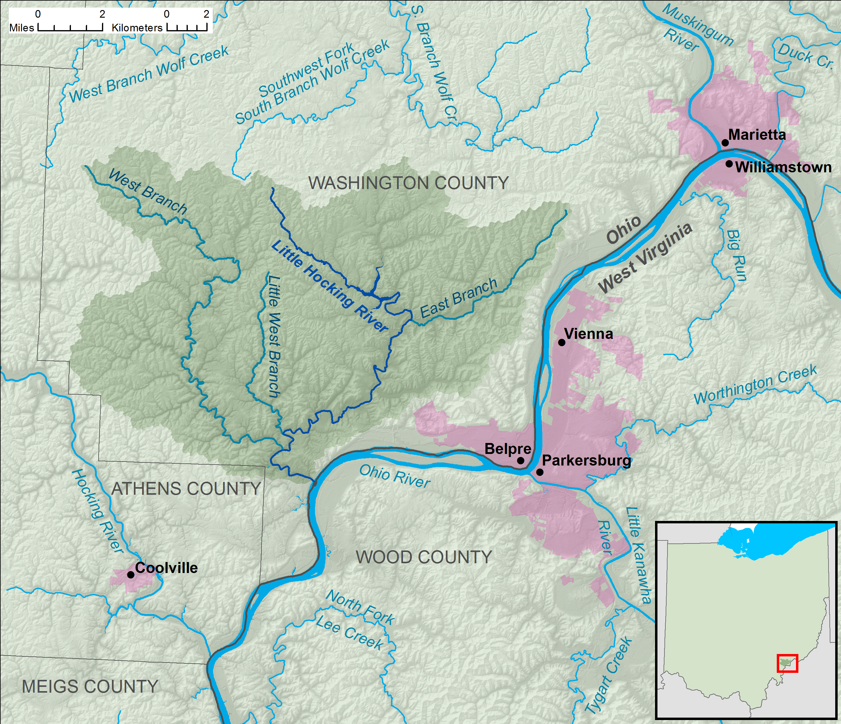
English: A map of the Little Hocking River and its watershed (USGS HUC-12 codes 050302020103, 050302020104, and 050302020105)
in Washington and Athens counties in Ohio. |
| 日期 | |
| 來源 | Own work, data from w:The National Map |
| 作者 | Tim Kiser (User:Malepheasant) |
授權條款
[編輯]
我,本作品的著作權持有者,決定用以下授權條款發佈本作品:
此檔案採用創用CC 姓名標示-相同方式分享 3.0 未在地化版本授權條款。
- 您可以自由:
- 分享 – 複製、發佈和傳播本作品
- 重新修改 – 創作演繹作品
- 惟需遵照下列條件:
- 姓名標示 – 您必須指名出正確的製作者,和提供授權條款的連結,以及表示是否有對內容上做出變更。您可以用任何合理的方式來行動,但不得以任何方式表明授權條款是對您許可或是由您所使用。
- 相同方式分享 – 如果您利用本素材進行再混合、轉換或創作,您必須基於如同原先的相同或兼容的條款,來分布您的貢獻成品。

|
已授權您依據自由軟體基金會發行的無固定段落、封面文字和封底文字GNU自由文件授權條款1.2版或任意後續版本,對本檔進行複製、傳播和/或修改。該協議的副本列在GNU自由文件授權條款中。 |
您可以選擇您需要的授權條款。
檔案歷史
點選日期/時間以檢視該時間的檔案版本。
| 日期/時間 | 縮圖 | 尺寸 | 使用者 | 備註 | |
|---|---|---|---|---|---|
| 目前 | 2013年11月28日 (四) 05:48 | | 2,763 × 2,378(6.99 MB) | TimK MSI(留言 | 貢獻) | redesign with topography, scale bar, additional labels |
| 2013年6月5日 (三) 02:13 |  | 2,763 × 2,378(224 KB) | TimK MSI(留言 | 貢獻) | {{Information |Description ={{en|1=A map of the Little Hocking River and its watershed (USGS HUC-12 codes 050302020103, 050302020104, and 050302020105) in Washington and Athens countie... |
無法覆蓋此檔案。
檔案用途
沒有使用此檔案的頁面。
全域檔案使用狀況
以下其他 wiki 使用了這個檔案:
- en.wikipedia.org 的使用狀況
- zh.wikipedia.org 的使用狀況