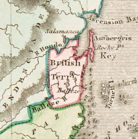
File:Lizars Mexico & Guatimala 1831 UTA (detail of British Territory--Balleze).jpg
Lizars_Mexico_&_Guatimala_1831_UTA_(detail_of_British_Territory--Balleze).jpg (555 × 557 pixelů, velikost souboru: 252 KB, MIME typ: image/jpeg)
Popisky
Popisky
Popis[editovat]
| Titul |
English: Mexico & Guatimala [sic] |
||||||||||||||||||||||||||
| PopisLizars Mexico & Guatimala 1831 UTA (detail of British Territory--Balleze).jpg |
English: The creator of this map was probably Daniel Lizars II (1793-1875), the son of Edinburgh map engraver and publisher Daniel Lizars I (1754-1812) and younger brother of William Home Lizars (1788-1859). Shortly after producing the map, Daniel II went bankrupt in 1832 and emigrated to Canada in 1833. Lizars' map shows Mexico's administrative districts as Intendencies (Intendencias) and Internal Provinces (Provincias Internas) dating from the Spanish era. His depiction of the area that became Texas is notably jarring to modern viewers because his map further exaggerated some of the cartographic errors of his predecessors and contemporaries: particularly, a southerly "dip" of the middle Red River and the southerly courses of the Trinity, Brazos, and Colorado Rivers (which actually flow southeasterly). Settlements shown include Nacogdoches, "St." Antonio, and "Loredo". Interestingly, Lizars included the "British Territory" that became British Honduras or Belize. British logging settlements existed in the territory by the late eighteenth century and, although the British government had been hesitant to create a colony for fear of provoking the Spanish, settlers there were largely self-governing. |
||||||||||||||||||||||||||
| Datum |
cca 1831 date QS:P,+1831-00-00T00:00:00Z/9,P1480,Q5727902 |
||||||||||||||||||||||||||
| Zdroj | UTA Libraries Cartographic Connections: mapa / text | ||||||||||||||||||||||||||
| Tvůrce |
creator QS:P170,Q12629547 |
||||||||||||||||||||||||||
| Způsob získání |
English: The University of Texas at Arlington Libraries Special Collections, Gift of Virginia Garrett |
||||||||||||||||||||||||||
| Geotemporal data | |||||||||||||||||||||||||||
| Map location | Belize | ||||||||||||||||||||||||||
| Georeferencing | Georeference the map in Wikimaps Warper If inappropriate please set warp_status = skip to hide. | ||||||||||||||||||||||||||
| Bibliographic data | |||||||||||||||||||||||||||
| Publikace |
The Edinburgh Geographical and Historical Atlas |
||||||||||||||||||||||||||
| Autor |
John Hamilton |
||||||||||||||||||||||||||
| Místo vydání |
Edinburgh Londýn Dublin |
||||||||||||||||||||||||||
| Vydavatel |
John Hamilton Whittaker, Treacher & Co. W. Curry, Jun. & Co. |
||||||||||||||||||||||||||
| Archival data | |||||||||||||||||||||||||||
| Sbírka |
institution QS:P195,Q1230739 |
||||||||||||||||||||||||||
| Rozměry |
výška: 42 cm; šířka: 51,5 cm dimensions QS:P2048,42U174728 dimensions QS:P2049,51.5U174728 |
||||||||||||||||||||||||||
| Technika | colored rytina na papíře | ||||||||||||||||||||||||||
| artwork-references |
Worms, Laurence; Ashley Baynton-Williams (2011) British Map Engravers, Londýn: Rare Book Society, pp. 406–409 |
||||||||||||||||||||||||||
| Další verze |
|
||||||||||||||||||||||||||
Licence[editovat]

|
This file was provided to Wikimedia Commons by the University of Texas at Arlington Libraries as part of a cooperation project. The University of Texas at Arlington Libraries is part of the University of Texas at Arlington, a public research university located in Arlington, Texas.
|
| Public domainPublic domainfalsefalse |
|
Autor zemřel v roce 1875, takže toto dílo je volné také v zemích, jejichž právní řád chrání majetková autorská práva po dobu života autora a 100 let po jeho smrti. Toto dílo je ve Spojených státech amerických dílem volným (public domain), protože tam bylo registrováno u U.S. Copyright Office nebo zveřejněno před 1. lednem 1929. | |
| Bylo zjištěno, že u tohoto souboru nejsou známa žádná omezení daná autorským právem a právy s ním souvisejícími. | |
https://creativecommons.org/publicdomain/mark/1.0/PDMCreative Commons Public Domain Mark 1.0falsefalse
Historie souboru
Kliknutím na datum a čas se zobrazí tehdejší verze souboru.
| Datum a čas | Náhled | Rozměry | Uživatel | Komentář | |
|---|---|---|---|---|---|
| současná | 17. 7. 2019, 15:52 |  | 555 × 557 (252 KB) | Michael Barera (diskuse | příspěvky) | File:Lizars Mexico & Guatimala 1831 UTA.jpg cropped 91 % horizontally, 89 % vertically using CropTool with precise mode. |
Tento soubor nemůžete přepsat.
Využití souboru
Na Commons na soubor odkazuje tato stránka:
Globální využití souboru
Tento soubor využívají následující wiki:
- Využití na ba.wikipedia.org
- Využití na br.wikipedia.org
- Využití na ca.wikipedia.org
- Využití na cs.wikipedia.org
- Využití na de.wikipedia.org
- Využití na en.wikipedia.org
- Využití na es.wikipedia.org
- Využití na fr.wikipedia.org
- Využití na hy.wikipedia.org
- Využití na io.wikipedia.org
- Využití na ja.wikipedia.org
- Využití na pl.wikipedia.org
- Využití na ru.wikipedia.org
- Využití na sq.wikipedia.org
- Využití na sv.wikipedia.org
- Využití na uk.wikipedia.org
- Využití na zh.wikipedia.org
Metadata
Tento soubor obsahuje dodatečné informace, poskytnuté zřejmě digitálním fotoaparátem nebo scannerem, kterým byl pořízen. Pokud byl soubor od té doby změněn, některé údaje mohou být neplatné.
| Název obrázku |
|
|---|---|
| Značka fotoaparátu | Better Light |
| Model fotoaparátu | Model Super8k |
| Expozice | 1/30 s (0,033333333333333) |
| Nastavení ISO citlivosti | 1 000 |
| Datum a čas pořízení obrázku | 23. 4. 2012, 13:27 |
| Šířka | 9 867 px |
| Výška | 10 000 px |
| Bitů na složku |
|
| Druh komprese | Nekomprimovaný |
| Barevný prostor | RGB |
| Orientace | Normální |
| Počet složek | 3 |
| Rozlišení obrázku na šířku | 300 dpi |
| Rozlišení obrázku na výšku | 300 dpi |
| Uspořádání dat | chunky |
| Použitý software | Adobe Photoshop CC (Windows) |
| Datum a čas vytvoření obrázku | 12. 7. 2019, 13:48 |
| Verze Exif | 2.2 |
| Datum a čas digitalizace | 23. 4. 2012, 13:27 |
| Expoziční čas (APEX) | 4,90689 |
| Podporovaná verze Flashpix | 0.1 |
| Barevný prostor | sRGB |
| Senzor | Trilineární senzor |
| Datum poslední úpravy metadat | 12. 7. 2019, 08:48 |
| Unikátní ID původního dokumentu | xmp.did:034F4A54A38DE111A050D1A0BF1C0C9E |
| Verze IIM | 29 146 |


