File:LocationKingdomAraucania.svg
跳转到导航
跳转到搜索

此SVG文件的PNG预览的大小:800 × 400像素。 其他分辨率:320 × 160像素 | 640 × 320像素 | 1,024 × 512像素 | 1,280 × 640像素 | 2,560 × 1,280像素 | 1,000 × 500像素。
原始文件 (SVG文件,尺寸为1,000 × 500像素,文件大小:987 KB)
说明
说明
添加一行文字以描述该文件所表现的内容
摘要[编辑]
| 描述 |
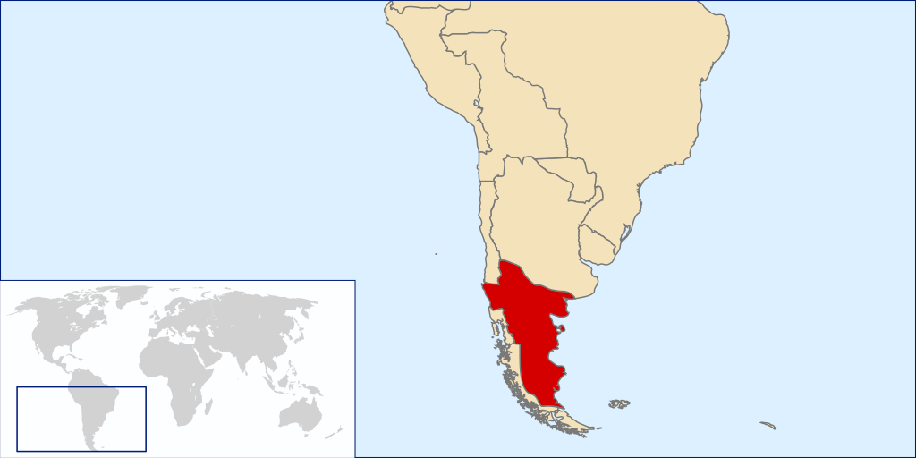
Español: Mapa localizador del Reino de la Araucanía y la Patagonia (1860-1862 aprox.).
Este mapa solo representa una idea básica de la localización del territorio reclamado por este estado no reconocido, puesto que no existe certeza exacta de las zonas reclamadas por el supuesto reino. Los mapas de otros países tampoco son representaciones fidedignas de sus fronteras en la época. La zona patagónica de Aisén, Magallanes y Tierra del Fuego aparece como un territorio distinto a Chile y Argentina al ser una zona reclamada por ambos países durante la época. La zona de la Patagonia Oriental, también reclamada por ambos, era cubierta por las reclamaciones del Reino de la Araucanía y la PatagoniaEnglish: Locator map of the Kingdom of Araucania and Patagonia (approx. 1860-1862).
The map shows only an idea of the territory disputed by the unrecognized Kingdom because there isn't any exact definition of it. Also the historical frontiers of other countries aren't accurate. The zone of Aysen, Magallanes and Tierra del Fuego islands are shown as a separate entity because it was disputed by Chile and Argentina at the time. Most of Western Patagonia (also disputed by both countries) are shown as a territory of the Kingdom. |
| 日期 | |
| 来源 | self-made based in Image:LocationChile.svg and Image:Continents.svg |
| 作者 | B1mbo |
许可协议[编辑]
我,本作品著作权人,特此采用以下许可协议发表本作品:

|
已授权您依据自由软件基金会发行的无固定段落及封面封底文字(Invariant Sections, Front-Cover Texts, and Back-Cover Texts)的GNU自由文件许可协议1.2版或任意后续版本的条款,复制、传播和/或修改本文件。该协议的副本请见“GNU Free Documentation License”。 |
This file is licensed under the Creative Commons Attribution-Share Alike 4.0 International, 3.0 Unported, 2.5 Generic, 2.0 Generic and 1.0 Generic license.
- 您可以自由地:
- 共享 – 复制、发行并传播本作品
- 修改 – 改编作品
- 惟须遵守下列条件:
- 署名 – 您必须对作品进行署名,提供授权条款的链接,并说明是否对原始内容进行了更改。您可以用任何合理的方式来署名,但不得以任何方式表明许可人认可您或您的使用。
- 相同方式共享 – 如果您再混合、转换或者基于本作品进行创作,您必须以与原先许可协议相同或相兼容的许可协议分发您贡献的作品。
您可以选择您需要的许可协议。
文件历史
点击某个日期/时间查看对应时刻的文件。
| 日期/时间 | 缩略图 | 大小 | 用户 | 备注 | |
|---|---|---|---|---|---|
| 当前 | 2008年3月29日 (六) 02:50 | | 1,000 × 500(987 KB) | B1mbo(留言 | 贡献) | {{Information |Description={{es|Mapa localizador del Reino de la Araucanía y la Patagonia (1860-1862 aprox.). Este mapa solo representa una idea básica de la localización del territorio reclamado por este |
您不可以覆盖此文件。
文件用途
以下3个页面使用本文件:
全域文件用途
以下其他wiki使用此文件:
- ar.wikipedia.org上的用途
- br.wikipedia.org上的用途
- ca.wikipedia.org上的用途
- en.wikipedia.org上的用途
- es.wikipedia.org上的用途
- fi.wikipedia.org上的用途
- fr.wikipedia.org上的用途
- ga.wikipedia.org上的用途
- gl.wikipedia.org上的用途
- he.wikipedia.org上的用途
- id.wikipedia.org上的用途
- it.wikipedia.org上的用途
- ja.wikipedia.org上的用途
- ko.wikipedia.org上的用途
- nl.wikipedia.org上的用途
- pt.wikipedia.org上的用途
- sv.wikipedia.org上的用途
- th.wikipedia.org上的用途
- www.wikidata.org上的用途
- zh.wikipedia.org上的用途