File:LocationMap-MarsCuriosityRover-Sol2692-20200303.jpg
跳转到导航
跳转到搜索

本预览的尺寸:800 × 600像素。 其他分辨率:320 × 240像素 | 640 × 480像素 | 1,024 × 768像素 | 1,280 × 960像素 | 2,560 × 1,920像素 | 4,800 × 3,600像素。
原始文件 (4,800 × 3,600像素,文件大小:2.24 MB,MIME类型:image/jpeg)
说明
说明
添加一行文字以描述该文件所表现的内容
Location Map - Mars Curiosity Rover - Sol 2692 - March 3, 2020
摘要
[编辑]
| 描述 |
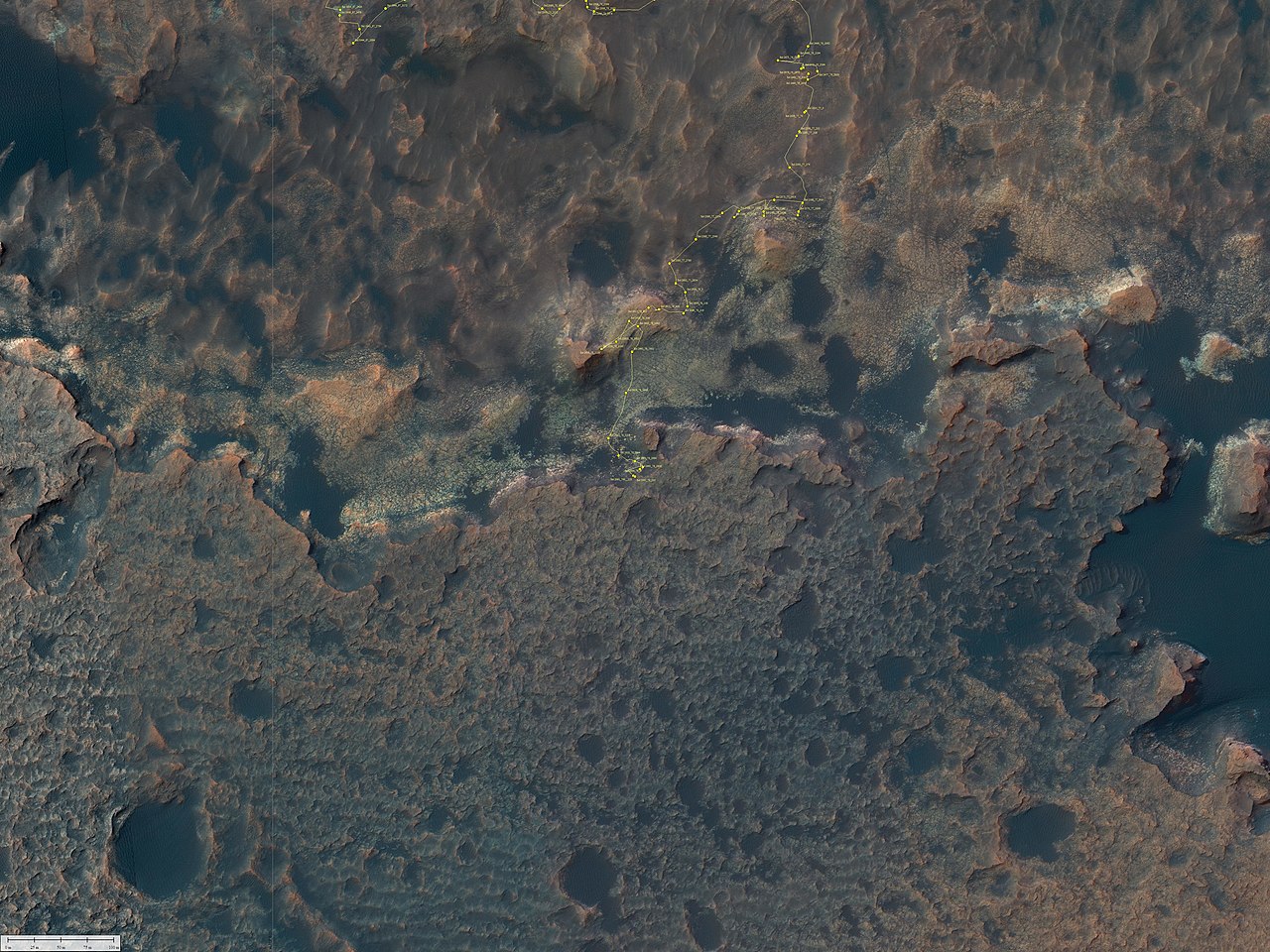
English: Curiosity Rover's Location for Sol 2692
https://mars.nasa.gov/resources/24799/curiosity-rovers-location-for-sol-2692/ March 03, 2020 This map shows the route driven by NASA's Mars rover Curiosity through the 2692 Martian day, or sol, of the rover's mission on Mars (March 3, 2020). Numbering of the dots along the line indicate the sol number of each drive. North is up. From Sol 2691 to Sol 2692, Curiosity had driven a straight line distance of about 5.68 feet (1.73 meters). Since touching down in Bradbury Landing in August 2012, Curiosity has driven 13.62 miles (21.92 kilometers). The base image from the map is from the High Resolution Imaging Science Experiment Camera (HiRISE) in NASA's Mars Reconnaissance Orbiter. |
| 日期 | |
| 来源 | https://mars.nasa.gov/system/resources/deepzooms/24799_Curiosity_Location_Sol2692.jpg |
| 作者 | NASA/JPL-Caltech/Univ. of Arizona |
许可协议
[编辑]
| 本文件完全由NASA创作,在美国属于公有领域。根据NASA的版权方针,NASA的材料除非另有声明否则不受版权保护。(参见Template:PD-USGov/zh、NASA版权方针页面或JPL图片使用方针。) | ||
 |
警告:
|
文件历史
点击某个日期/时间查看对应时刻的文件。
| 日期/时间 | 缩略图 | 大小 | 用户 | 备注 | |
|---|---|---|---|---|---|
| 当前 | 2020年3月15日 (日) 20:58 | | 4,800 × 3,600(2.24 MB) | Drbogdan(留言 | 贡献) | Uploaded a work by NASA/JPL-Caltech/Univ. of Arizona from https://mars.nasa.gov/system/resources/deepzooms/24799_Curiosity_Location_Sol2692.jpg with UploadWizard |
您不可以覆盖此文件。
文件用途
全域文件用途
以下其他wiki使用此文件:
- en.wikipedia.org上的用途
- zh.wikipedia.org上的用途