File:LocationNSAm2.png
Spring til navigation
Spring til søgning

Størrelse af denne forhåndsvisning: 600 × 600 pixels. Andre opløsninger: 240 × 240 pixels | 480 × 480 pixels.
Oprindelig fil (800 × 800 billedpunkter, filstørrelse: 21 KB, MIME-type: image/png)
Captions
Captions
Tilføj en kort forklaring på en enkelt linje om hvad filen viser
Beskrivelse
[redigér]
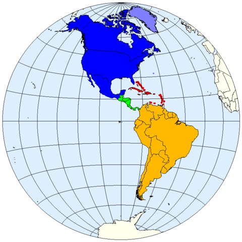
| Beskrivelse | Division of the Americas into North, Central and South America and the West Indies. |
| Dato | |
| Kilde | prepared from public domain maps created by w:en:User:E Pluribus Anthony. |
| Forfatter | Spacepotato |
Legend
[redigér]
- 0000FF: North America.
- 8080FF: Sometimes included in North America.
- 00FF06: Central America.
- FF0000: West Indies.
- FFBA00: South America.
References
[redigér]
- MSN Encarta archive copy at the Wayback Machine, Microsoft. Accessed on line October 15, 2007. Divides the Western Hemisphere into North America, Central America, the West Indies, and South America.
- "North America archive copy at the Wayback Machine". MSN Encarta, Microsoft. Accessed on line October 11, 2007. Defines North America as including Canada, the USA, Mexico, Greenland, St. Pierre and Miquelon, and Bermuda.
- "Central America archive copy at the Wayback Machine". MSN Encarta, Microsoft. Accessed on line October 12, 2007. Defines Central America as including Belize, Costa Rica, El Salvador, Guatemala, Honduras, Nicaragua, and Panama.
Licensering
[redigér]
| Jeg, indehaveren af ophavsretten til dette værk, udgiver dette værk som offentlig ejendom. Dette gælder i hele verden. I nogle lande er dette ikke juridisk muligt. I så fald: Jeg giver enhver ret til at anvende dette værk til ethvert formål, uden nogen restriktioner, medmindre sådanne restriktioner er påkrævede ved lov. |
See also
[redigér]
Filhistorik
Klik på en dato/tid for at se filen som den så ud på det tidspunkt.
| Dato/tid | Miniaturebillede | Dimensioner | Bruger | Kommentar | |
|---|---|---|---|---|---|
| nuværende | 12. okt. 2007, 00:40 | | 800 × 800 (21 KB) | Spacepotato (diskussion | bidrag) | |
| 11. okt. 2007, 22:03 |  | 800 × 798 (21 KB) | Spacepotato (diskussion | bidrag) | == Summary == {{Information |Description=Division of the Americas into North, Central and South America and the West Indies. |Source=prepared from public domain maps created by w:en:User:E Pluribus Anthony. |Date=October 11, 2007. |Author= [[User:Spac |
Du kan ikke overskrive denne fil.
Filanvendelse
Der er ingen sider der bruger denne fil.
Global filanvendelse
Følgende andre wikier anvender denne fil:
- Anvendelser på ar.wikipedia.org
- Anvendelser på bn.wikipedia.org
- Anvendelser på ca.wikipedia.org
- Anvendelser på en.wikipedia.org
- Anvendelser på eu.wikipedia.org
- Anvendelser på kn.wikipedia.org
- Anvendelser på pt.wikipedia.org