File:Location of Happisburgh.png
跳转到导航
跳转到搜索
本预览的尺寸:490 × 600像素。 其他分辨率:196 × 240像素 | 392 × 480像素 | 628 × 768像素 | 837 × 1,024像素 | 2,067 × 2,529像素。
原始文件 (2,067 × 2,529像素,文件大小:795 KB,MIME类型:image/png)
说明
说明
添加一行文字以描述该文件所表现的内容
摘要[编辑]
| 描述 |
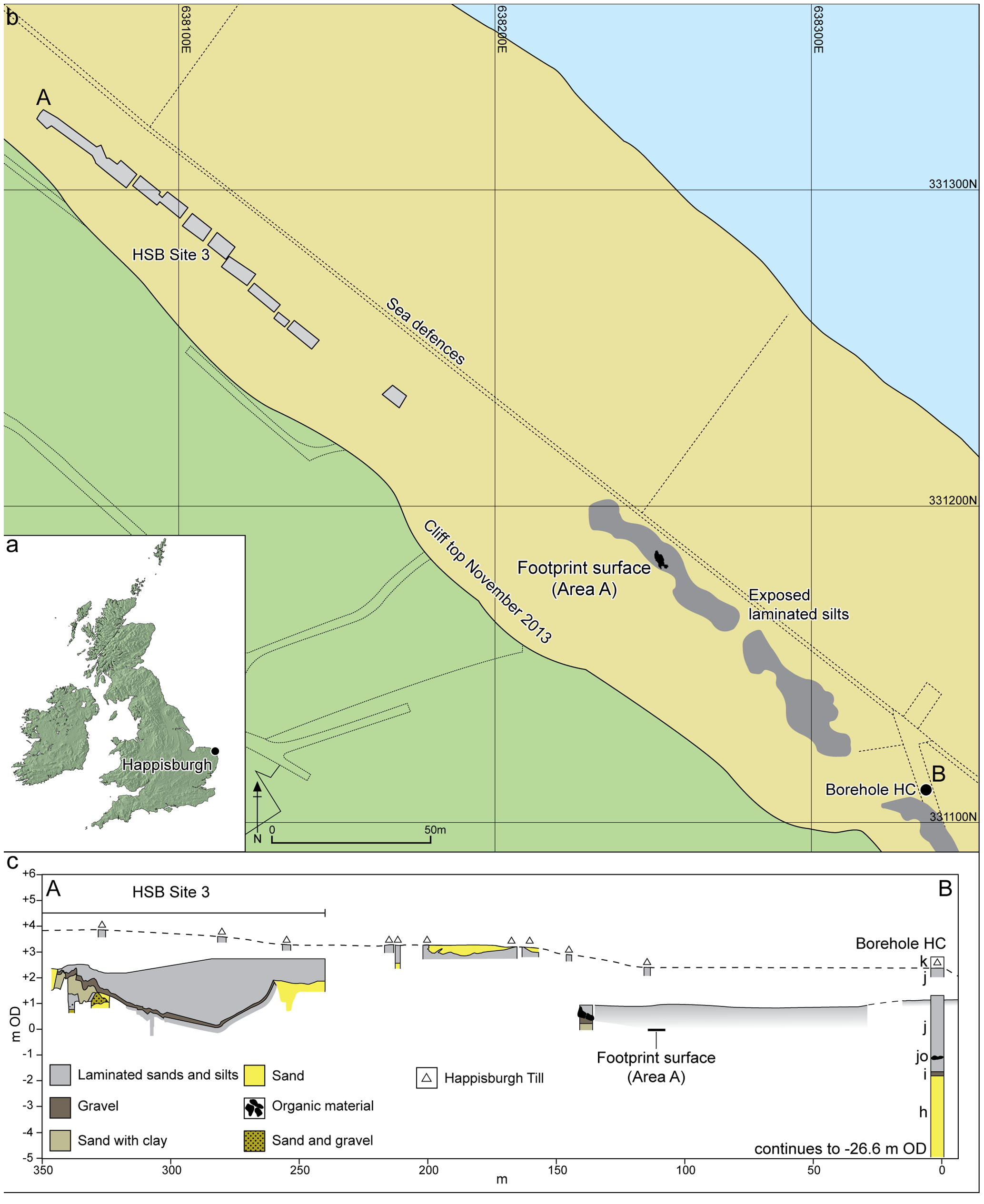
English: Figure 2. Location of Happisburgh. a. Map of UK showing location of Happisburgh; b. Plan of Happisburgh Site 3, exposed and recorded foreshore sediments, location of footprint surface and of borehole HC; c. Schematic cross-section of recorded sediments from Happisburgh Site 3 through to borehole HC showing stratigraphic position of footprint surface. Beds h–k are shown for borehole HC as recorded by West. doi:10.1371/journal.pone.0088329.g002 |
| 日期 | |
| 来源 | Nick Ashton, Simon G. Lewis, Isabelle De Groote, Sarah M. Duffy, Martin Bates, Richard Bates, Peter Hoare, Mark Lewis, Simon A. Parfitt, Sylvia Peglar, Craig Williams, Chris Stringer (2014) Hominin Footprints from Early Pleistocene Deposits at Happisburgh, UK. PLoS ONE 9(2): e88329. doi:10.1371/journal.pone.0088329 |
| 作者 | Nick Ashton, Simon G. Lewis, Isabelle De Groote, Sarah M. Duffy, Martin Bates, Richard Bates, Peter Hoare, Mark Lewis, Simon A. Parfitt, Sylvia Peglar, Craig Williams, Chris Stringer |
| 相机位置 | | 在以下服务上查看本图像和附近其他图像: OpenStreetMap |
|---|
许可协议[编辑]
文件历史
点击某个日期/时间查看对应时刻的文件。
| 日期/时间 | 缩略图 | 大小 | 用户 | 备注 | |
|---|---|---|---|---|---|
| 当前 | 2014年2月7日 (五) 23:46 | | 2,067 × 2,529(795 KB) | BabelStone(留言 | 贡献) | User created page with UploadWizard |
您不可以覆盖此文件。
文件用途
全域文件用途
以下其他wiki使用此文件:
- ar.wikipedia.org上的用途
- en.wikipedia.org上的用途
- ja.wikipedia.org上的用途
- zh.wikipedia.org上的用途