File:LondonHarrow.svg
Aller à la navigation
Aller à la recherche

Taille de cet aperçu PNG pour ce fichier SVG : 775 × 599 pixels. Autres résolutions : 310 × 240 pixels | 621 × 480 pixels | 993 × 768 pixels | 1 280 × 990 pixels | 2 560 × 1 980 pixels | 962 × 744 pixels.
Fichier d’origine (Fichier SVG, nominalement de 962 × 744 pixels, taille : 19 kio)
Légendes
Légendes
Ajoutez en une ligne la description de ce que représente ce fichier
Description
[modifier]| Description |
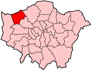
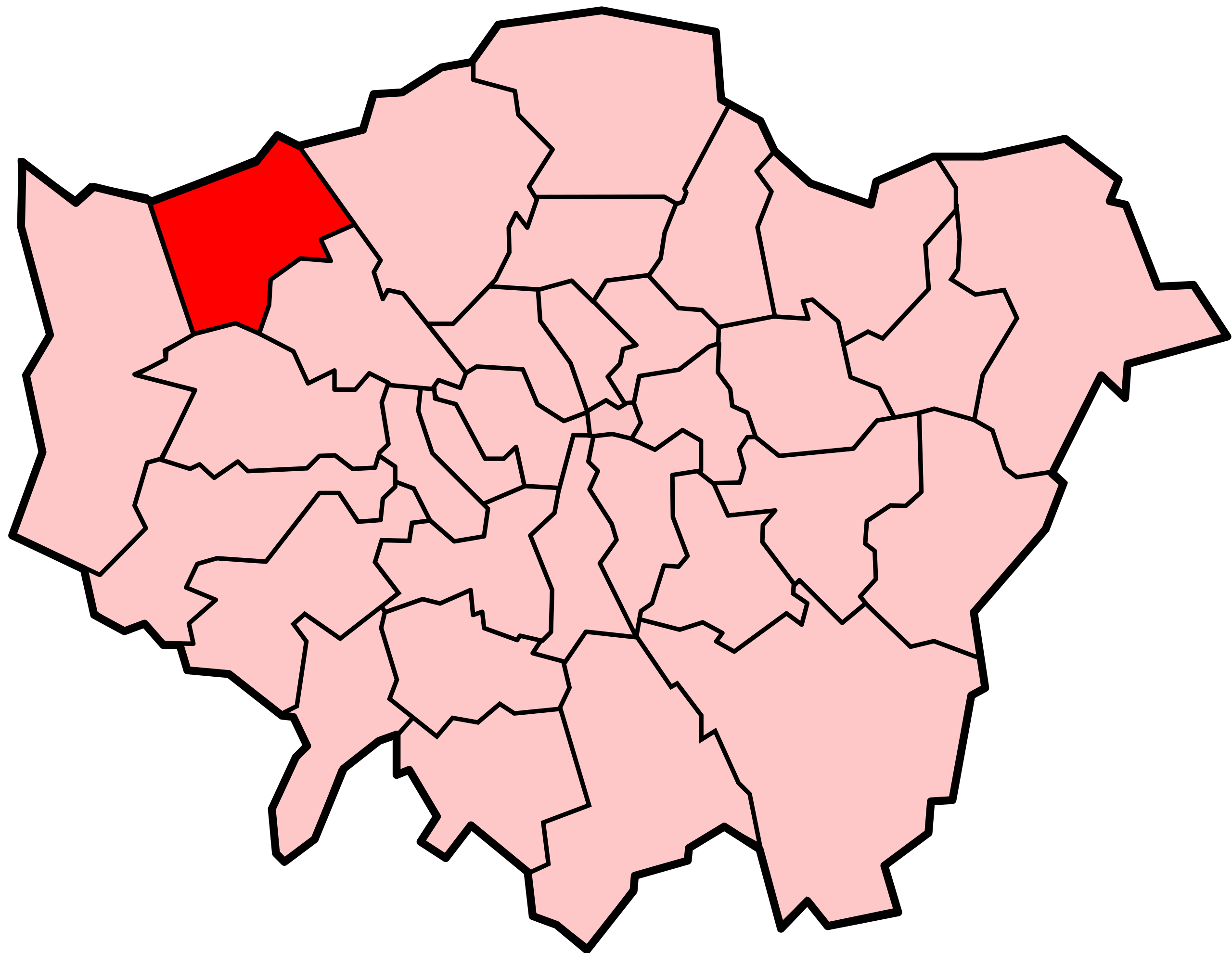
Locator map of the London Borough of Harrow, shown (in red) within Greater London. Cette image vectorielle SVG non W3C-spécifiée a été créée avec Inkscape . |
||||||||
| Date | |||||||||
| Source | Adapted from Image:LondonHarrow.png and Image:BlankMap-LondonBoroughs.svg. | ||||||||
| Auteur | Image:LondonHarrow.png by Morwen, Image:BlankMap-LondonBoroughs.svg by Richtom80 | ||||||||
| Autorisation (Réutilisation de ce fichier) |
Moi, en tant que détenteur des droits d’auteur sur cette œuvre, je la publie sous les licences suivantes :
Ce fichier est disponible selon les termes de la licence Creative Commons Attribution 2.5 Générique.
Vous pouvez choisir l’une de ces licences. |
||||||||
| Autres versions | PNG version |

Historique du fichier
Cliquer sur une date et heure pour voir le fichier tel qu'il était à ce moment-là.
| Date et heure | Vignette | Dimensions | Utilisateur | Commentaire | |
|---|---|---|---|---|---|
| actuel | 7 décembre 2007 à 00:02 | | 962 × 744 (19 kio) | Fvasconcellos (d | contributions) | == Summary == {{Information |Description= Locator map of the {{w|London Borough of Harrow}}, shown (in red) within {{w|Greater London}}.{{Inkscape}} |Source= Adapted from Image:LondonHarrow.png and Image:BlankMap-LondonBoroughs.svg. |Date= De |
Vous ne pouvez pas remplacer ce fichier.
Utilisations locales du fichier
Les 7 pages suivantes utilisent ce fichier :
- File:LondonHarrow.png
- Category:London Borough of Harrow
- Category:People of the London Borough of Harrow
- Category:Railway stations in the London Borough of Harrow
- Category:Sports in the London Borough of Harrow
- Category:Transport in the London Borough of Harrow
- Category:Views of the London Borough of Harrow
Utilisations du fichier sur d’autres wikis
Les autres wikis suivants utilisent ce fichier :
- Utilisation sur ar.wikipedia.org
- Utilisation sur azb.wikipedia.org
- Utilisation sur ca.wikipedia.org
- Utilisation sur cy.wikipedia.org
- Utilisation sur da.wikipedia.org
- Utilisation sur en.wikipedia.org
- List of places in London
- Hatch End
- Kenton, London
- Pinner
- Stanmore
- Wealdstone
- London Borough of Harrow
- North London
- Harrow, London
- Belmont, Harrow
- North Harrow
- Harrow Weald
- Burnt Oak
- West Harrow
- Harrow on the Hill
- Parks and open spaces in the London Borough of Harrow
- South Harrow
- Canons Park
- St Mary's Church, Harrow on the Hill
- Rayners Lane
- Sudbury, London
- Roxeth
- Headstone, London
- Queensbury, London
- Category:People from Pinner
- Category:People from Kenton, London
- Greenhill, Harrow
- Template:LB Harrow
- Category:People from South Harrow
- Category:People from Harrow on the Hill
- Headstone Manor and Museum
- Category:People from Stanmore
- Little Stanmore
- Category:London Borough of Harrow
- Brockley Hill
- List of people from the London Borough of Harrow
- Sudbury Hill
- List of public art in the London Borough of Harrow
- Category:People from Harrow, London
- Pinner Green
- Grade I and II* listed buildings in the London Borough of Harrow
- Roxbourne
- Wikipedia:WikiProject Navigation templates/Country subdivisions/United Kingdom/England
Voir davantage sur l’utilisation globale de ce fichier.