File:Loyalty Islands map.png
Zur Navigation springen
Zur Suche springen

Greßi vu däre Vorschau: 669 × 599 Pixel. Wyteri Ufflösige: 268 × 240 Pixel | 536 × 480 Pixel | 693 × 621 Pixel.
Originaldatei (693 × 621 Pixel, Dateigrößi: 125 KB, MIME-Typ: image/png)
Bildtexte
Kurzbeschreibungen
Ergänze eine einzeilige Erklärung, was diese Datei darstellt.
Bschryybig[ändere]
| Bschryybig |
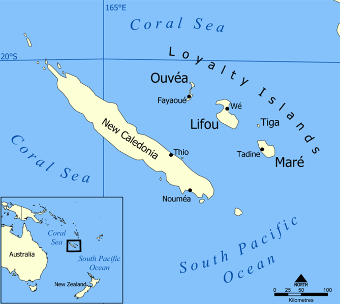
A map showing the location of the Loyalty Islands in the South Pacific Ocean. The islands include Lifou, Mare, Ouvea and Tiga, and nearby New Caledonia. Created by NormanEinstein, May 25, 2005. |
| Datum | 24. Mai 2005 (Original-Hochladedatum) |
| Quälle | No machine-readable source provided. Own work assumed (based on copyright claims). |
| Urheber | No machine-readable author provided. NormanEinstein assumed (based on copyright claims). |
Lizänzierig[ändere]
Ich haa s Urheberrächt an däm Wärch un vereffetlig s dodermit unter däne Lizänze:

|
Des Dokumänt derf kopiert, verbreitet un/oder bearbeitet wäre unter dr Bedingige vu dr GNU-Lizänz fir freji Dokumäntation, Version 1.2 oder ere spetere Version, vereffetligt dur Free Software Foundation. S het keini uuveränderlige Abschnitt, kei vordere Umschlagstext un kei hindere Umschlagstext. E Kopii vu dr Lizänz isch verfiegbar im Abschnitt GNU-Lizänz fir freji Dokumäntation. |
| Die Datei isch lizänziert unter dr Creative-Commons-Lizenz Namensnännig – Wytergab unter glyche Bedingige 3.0 nit portiert. | ||
| ||
| Die Lizänzmarkierig isch wäg em GFDL-Lizänzupdate zuegfiegt wore. |
Du chasch sälber e Lizänz uuswehle.
Dateiversione
Klick uf e Zytpunkt zu aazeige, wie s dert usgsäh het.
| Version vom | Vorschaubild | Mäß | Benutzer | Kommentar | |
|---|---|---|---|---|---|
| aktuell | 21:51, 11. Dez. 2021 | | 693 × 621 (125 KB) | Lojwe (Diskussion | Byträg) | Cropped 1 % horizontally, 1 % vertically using CropTool with precise mode. |
| 20:51, 24. Mei 2005 |  | 700 × 628 (147 KB) | NormanEinstein (Diskussion | Byträg) | A map showing the location of the Loyalty Islands in the South Pacific Ocean. The islands include Lifou, Mare, Ouvea and Tiga, and nearby New Caledonia. Created by NormanEinstein, May 25, 2005. {{GFDL-self}} |
Du chasch die Datei nit iberschryybe.
Verwändig vu dr Datei
Die 2 Syte bruuche die Datei:
Wältwyti Dateinutzig
Die andere Wikis bruche die Datei:
- Gebruch uf als.wikipedia.org
- Gebruch uf ar.wikipedia.org
- Gebruch uf ast.wikipedia.org
- Gebruch uf ceb.wikipedia.org
- Gebruch uf cs.wikipedia.org
- Gebruch uf da.wikipedia.org
- Gebruch uf de.wikipedia.org
- Gebruch uf de.wikivoyage.org
- Gebruch uf el.wikipedia.org
- Gebruch uf en.wikipedia.org
- Gebruch uf eo.wikipedia.org
- Gebruch uf es.wikipedia.org
- Gebruch uf eu.wikipedia.org
- Gebruch uf fi.wikipedia.org
- Gebruch uf frr.wikipedia.org
- Gebruch uf fr.wiktionary.org
- Gebruch uf gl.wikipedia.org
- Gebruch uf it.wikipedia.org
- Gebruch uf ja.wikipedia.org
- Gebruch uf ka.wikipedia.org
- Gebruch uf ky.wikipedia.org
- Gebruch uf lt.wikipedia.org
- Gebruch uf mk.wikipedia.org
- Gebruch uf mrj.wikipedia.org
- Gebruch uf nl.wikipedia.org
- Gebruch uf nn.wikipedia.org
Wältwyti Verwändig vu däre Datei aaluege.