File:Lunae Palus map.JPG
跳至導覽
跳至搜尋
無更高解析度可提供。
Lunae_Palus_map.JPG (638 × 427 像素,檔案大小:47 KB,MIME 類型:image/jpeg)
說明
說明
添加單行說明來描述出檔案所代表的內容
摘要
[編輯]
| 描述 |
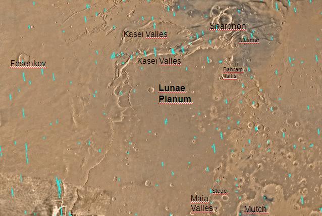
English: Map of Lunae Palus quadrangle with labels. The small, colored rectangles represent image footprints for the narrow angle camera on the Mars Global Surveyor. Some are about 1 mile wide, the otheers are about 2 miles wide. Português: Mapa do quadrângulo de Lunae Plus, em Marte |
| 日期 | |
| 來源 | http://www.msss.com/moc_gallery/s05_s10/mc10.html |
| 作者 | The map was made by the U.S. Geological survey for NASA. Jim Secosky (Jimmarsmars at en.wikipedia) modified. |
授權條款
[編輯]
| 本作品由NASA創作,屬於公有領域。根據NASA的版權政策:“NASA的創作除非另有聲明否則不受版權保護。”(參見:Template:PD-USGov/zh,NASA版權政策或JPL圖像使用政策) | ||
 |
警告:
|
原始上傳日誌
[編輯]
The original description page was here. All following user names refer to en.wikipedia.
- 2008-12-29 19:57 Jimmarsmars 638×427× (48204 bytes) {{Information |Description=Map of Lunae Palus map with labels |Source=http://www.msss.com/moc_gallery/s05_s10/mc10.html |Date=December 29, 2008 |Author=Jim Secosky modified NASA map. |Permission= |other_versions= }}
檔案歷史
點選日期/時間以檢視該時間的檔案版本。
| 日期/時間 | 縮圖 | 尺寸 | 使用者 | 備註 | |
|---|---|---|---|---|---|
| 目前 | 2011年1月21日 (五) 14:52 | | 638 × 427(47 KB) | Romullo(留言 | 貢獻) | {{Information |Description= Mapa do quadrângulo de Lunae Plus, em Marte |Source= Wiki:en |Date=21/01/11 |Author=NASA |Permission= |other_versions=http://upload.wikimedia.org/wikipedia/en/2/29/Lunae_Palus_map.JPG }} |
無法覆蓋此檔案。
檔案用途
沒有使用此檔案的頁面。
全域檔案使用狀況
以下其他 wiki 使用了這個檔案:
- en.wikipedia.org 的使用狀況
- es.wikipedia.org 的使用狀況
- hi.wikipedia.org 的使用狀況
- ja.wikipedia.org 的使用狀況
- ml.wikipedia.org 的使用狀況
- pt.wikipedia.org 的使用狀況
- ru.wikipedia.org 的使用狀況
- tr.wikipedia.org 的使用狀況
- uk.wikipedia.org 的使用狀況
- zh.wikipedia.org 的使用狀況