File:MGRSgridSouthPole.png
跳转到导航
跳转到搜索

本预览的尺寸:798 × 600像素。 其他分辨率:320 × 240像素 | 639 × 480像素 | 1,022 × 768像素 | 1,280 × 962像素 | 1,469 × 1,104像素。
原始文件 (1,469 × 1,104像素,文件大小:1,023 KB,MIME类型:image/png)
说明
说明
添加一行文字以描述该文件所表现的内容
摘要
[编辑]
| 描述 |
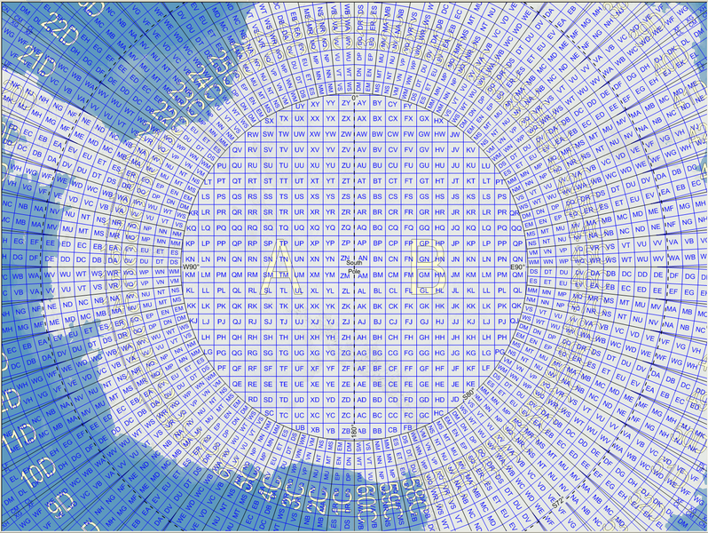
English: Map of the Military Grid Reference System (MGRS) around the South Pole, with the AA lettering scheme for the 100 km squares north of 80°S. |
| 日期 | |
| 来源 |
English: Mikael R made the MGRS grid in Carmenta Engine, with a background map from Natural Earth by Tom Patterson, US National Park Service. |
| 作者 | Mikael Rittri (MikaelR) |
许可协议
[编辑]
本文件采用知识共享署名-相同方式共享 3.0 未本地化版本许可协议授权。
- 您可以自由地:
- 共享 – 复制、发行并传播本作品
- 修改 – 改编作品
- 惟须遵守下列条件:
- 署名 – 您必须对作品进行署名,提供授权条款的链接,并说明是否对原始内容进行了更改。您可以用任何合理的方式来署名,但不得以任何方式表明许可人认可您或您的使用。
- 相同方式共享 – 如果您再混合、转换或者基于本作品进行创作,您必须以与原先许可协议相同或相兼容的许可协议分发您贡献的作品。
文件历史
点击某个日期/时间查看对应时刻的文件。
| 日期/时间 | 缩略图 | 大小 | 用户 | 备注 | |
|---|---|---|---|---|---|
| 当前 | 2007年11月21日 (三) 11:59 | | 1,469 × 1,104(1,023 KB) | MikaelR(留言 | 贡献) | {{Information |Description={{en|Map of the Military Grid Reference System (MGRS) around the South Pole, with the AA lettering scheme for the 100 km squares north of 80°S.}} |Source={{en|Mikael R made the MGRS grid in SpatialAce of Carmenta, with a backgr |
您不可以覆盖此文件。
文件用途
没有页面使用本文件。
全域文件用途
以下其他wiki使用此文件:
- en.wikipedia.org上的用途
- fi.wikipedia.org上的用途
- uk.wikipedia.org上的用途
- zh.wikipedia.org上的用途