File:MGRSgridSouthPole.png
跳至導覽
跳至搜尋

預覽大小:798 × 600 像素。 其他解析度:320 × 240 像素 | 639 × 480 像素 | 1,022 × 768 像素 | 1,280 × 962 像素 | 1,469 × 1,104 像素。
原始檔案 (1,469 × 1,104 像素,檔案大小:1,023 KB,MIME 類型:image/png)
說明
說明
添加單行說明來描述出檔案所代表的內容
摘要
[編輯]
| 描述 |
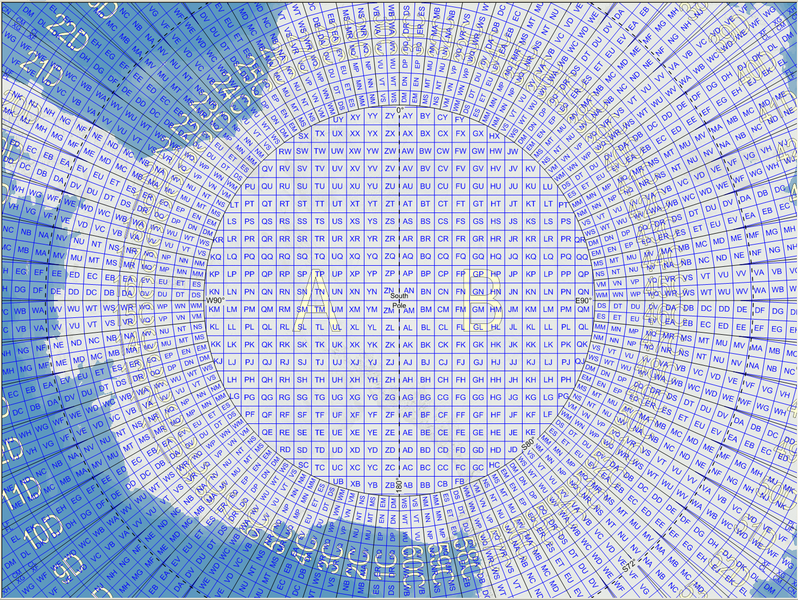
English: Map of the Military Grid Reference System (MGRS) around the South Pole, with the AA lettering scheme for the 100 km squares north of 80°S. |
| 日期 | |
| 來源 |
English: Mikael R made the MGRS grid in Carmenta Engine, with a background map from Natural Earth by Tom Patterson, US National Park Service. |
| 作者 | Mikael Rittri (MikaelR) |
授權條款
[編輯]
此檔案採用共享創意 姓名標示-相同方式分享 3.0 未在地化版本授權條款。
- 您可以自由:
- 分享 – 複製、發佈和傳播本作品
- 重新修改 – 創作演繹作品
- 惟需遵照下列條件:
- 姓名標示 – 您必須指名出正確的製作者,和提供授權條款的連結,以及表示是否有對內容上做出變更。您可以用任何合理的方式來行動,但不得以任何方式表明授權條款是對您許可或是由您所使用。
- 相同方式分享 – 如果您利用本素材進行再混合、轉換或創作,您必須基於如同原先的相同或兼容的條款,來分布您的貢獻成品。
檔案歷史
點選日期/時間以檢視該時間的檔案版本。
| 日期/時間 | 縮圖 | 尺寸 | 用戶 | 備註 | |
|---|---|---|---|---|---|
| 目前 | 2007年11月21日 (三) 11:59 | | 1,469 × 1,104(1,023 KB) | MikaelR(對話 | 貢獻) | {{Information |Description={{en|Map of the Military Grid Reference System (MGRS) around the South Pole, with the AA lettering scheme for the 100 km squares north of 80°S.}} |Source={{en|Mikael R made the MGRS grid in SpatialAce of Carmenta, with a backgr |
無法覆蓋此檔案。
檔案用途
沒有使用此檔案的頁面。
全域檔案使用狀況
以下其他 wiki 使用了這個檔案:
- en.wikipedia.org 的使用狀況
- fi.wikipedia.org 的使用狀況
- uk.wikipedia.org 的使用狀況
- zh.wikipedia.org 的使用狀況