File:Ma-on 2004-10-08 0408Z.jpg

原始檔案 (5,600 × 5,600 像素,檔案大小:4.77 MB,MIME 類型:image/jpeg)
說明
說明
摘要
[編輯]| 描述 |
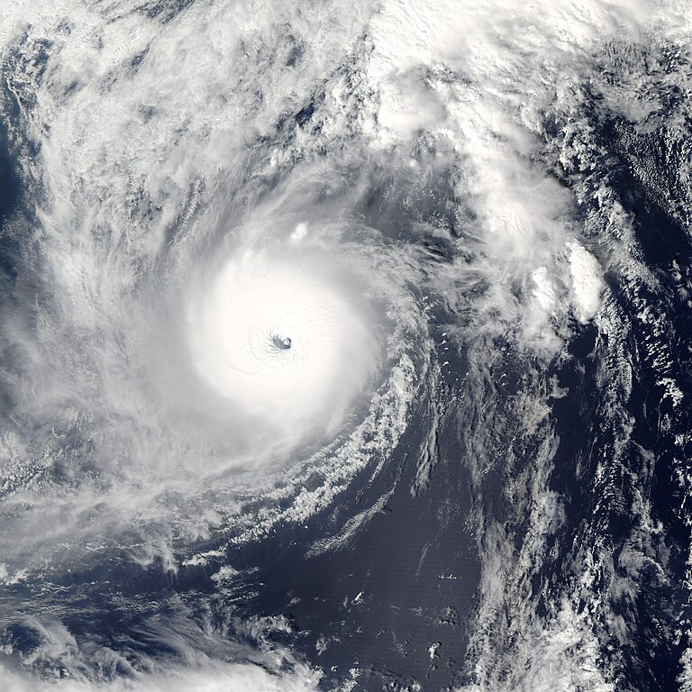
With sustained winds of 160 mph (257 kph) and gusts of up to 185 mph (298 kph), Super Typhoon Ma-On was situated due south of Japan on October 8, 2004. The eye of the storm was located about 621 miles (1,000 km) southwest of Tokyo and was moving north-northeastward at about 25 mph (40 kph). As the waters south of Japan are currently warmer than average, Ma-On may not weaken much as it approaches Japan, making it an extremely dangerous storm. Given its current trajectory, forecasts suggest that Super Typhoon Ma-On will make landfall somewhere between Kyoto and Tokyo within the next 48 hours. As Ma-On passes over mountains in the central part of the island, there will likely be extremely heavy precipitation in various places with the potential for flash flooding and mudslides. Local residents are encouraged to take safety precautions. The U.S. Navy’s Joint Typhoon Warning Center is an excellent source of timely information about Typhoon Ma-On as it approaches land. The true-color image above was acquired on October 8, 2004, by the Moderate Resolution Imaging Spectroradiometer (MODIS) aboard NASA's Aqua satellite. The high-resolution copy available above is 250 meters per pixel, but additional copies are also available. |
|||||
| 日期 | ||||||
| 來源 | http://rapidfire.sci.gsfc.nasa.gov/gallery/?2004282-1008/Ma-On.A2004282.0405 | |||||
| 作者 | Moderate Resolution Imaging Spectroradiometer (MODIS) image from NASA's Terra satellite | |||||
| 授權許可 (重用此檔案) |
|
|||||
| 其他版本 | Image:ST Ma-On 08 oct 2004 0405Z.jpg |

檔案歷史
點選日期/時間以檢視該時間的檔案版本。
| 日期/時間 | 縮圖 | 尺寸 | 使用者 | 備註 | |
|---|---|---|---|---|---|
| 目前 | 2023年7月31日 (一) 06:14 | | 5,600 × 5,600(4.77 MB) | Nino Marakot(留言 | 貢獻) | Reverted to version as of 03:57, 9 September 2006 (UTC) |
| 2022年11月9日 (三) 04:11 |  | 5,100 × 6,800(13.89 MB) | TheWxResearcher(留言 | 貢獻) | Dimensions | |
| 2020年12月2日 (三) 02:13 |  | 4,815 × 4,772(3.29 MB) | Destroyeraa(留言 | 貢獻) | Cropped 14 % horizontally, 15 % vertically using CropTool with precise mode. More focused on the storm | |
| 2006年9月9日 (六) 03:57 |  | 5,600 × 5,600(4.77 MB) | Good kitty(留言 | 貢獻) | == Summary == {{Information |Description=With sustained winds of 160 mph (257 kph) and gusts of up to 185 mph (298 kph), Super Typhoon Ma-On was situated due south of Japan on October 8, 2004. The eye of the storm was located about 621 miles (1,000 km) so |
無法覆蓋此檔案。
檔案用途
下列2個頁面有用到此檔案:
全域檔案使用狀況
以下其他 wiki 使用了這個檔案:
- en.wikipedia.org 的使用狀況
- ko.wikipedia.org 的使用狀況
- pt.wikipedia.org 的使用狀況
- th.wikipedia.org 的使用狀況
- tl.wikipedia.org 的使用狀況
- vi.wikipedia.org 的使用狀況
- www.wikidata.org 的使用狀況
- zh.wikipedia.org 的使用狀況