File:Mali sat.png
跳至導覽
跳至搜尋

預覽大小:665 × 599 像素。 其他解析度:266 × 240 像素 | 533 × 480 像素 | 852 × 768 像素 | 1,137 × 1,024 像素 | 1,979 × 1,783 像素。
原始檔案 (1,979 × 1,783 像素,檔案大小:3.58 MB,MIME 類型:image/png)
說明
說明
添加單行說明來描述出檔案所代表的內容
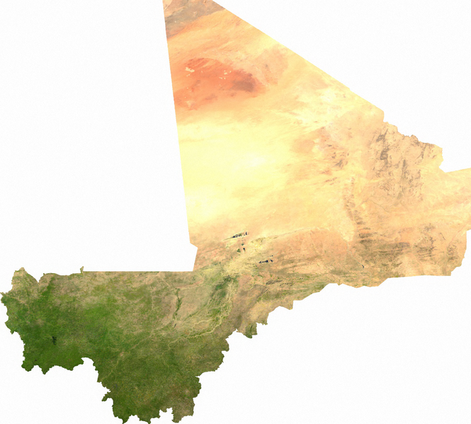
ECW to TIFF to PNG (compression level 9).
| This file is in the public domain, because it was generated by a user, using free sources available at The Map Library.
Note that this does not include the maps in the Global Administrative Areas section of the homepage. |
檔案歷史
點選日期/時間以檢視該時間的檔案版本。
| 日期/時間 | 縮圖 | 尺寸 | 用戶 | 備註 | |
|---|---|---|---|---|---|
| 目前 | 2006年7月14日 (五) 02:32 | | 1,979 × 1,783(3.58 MB) | Unquietwiki(對話 | 貢獻) | ECW to TIFF to PNG (compression level 9). {{PD-MapLibrary}} |
無法覆蓋此檔案。
檔案用途
下列2個頁面有用到此檔案:
全域檔案使用狀況
以下其他 wiki 使用了這個檔案:
- af.wikipedia.org 的使用狀況
- als.wikipedia.org 的使用狀況
- ar.wikipedia.org 的使用狀況
- bs.wikipedia.org 的使用狀況
- ca.wikipedia.org 的使用狀況
- de.wikipedia.org 的使用狀況
- de.wikivoyage.org 的使用狀況
- en.wikipedia.org 的使用狀況
- es.wikipedia.org 的使用狀況
- fi.wikipedia.org 的使用狀況
- fr.wikipedia.org 的使用狀況
- hu.wikipedia.org 的使用狀況
- hy.wikipedia.org 的使用狀況
- id.wikipedia.org 的使用狀況
- incubator.wikimedia.org 的使用狀況
- io.wikipedia.org 的使用狀況
- it.wikipedia.org 的使用狀況
- ka.wikipedia.org 的使用狀況
- ky.wikipedia.org 的使用狀況
- mdf.wikipedia.org 的使用狀況
- mn.wikipedia.org 的使用狀況
- pl.wikipedia.org 的使用狀況
- pt.wikipedia.org 的使用狀況
- ru.wikipedia.org 的使用狀況
- si.wikipedia.org 的使用狀況
- sr.wikipedia.org 的使用狀況
- te.wikipedia.org 的使用狀況
- trv.wikipedia.org 的使用狀況
- uk.wikipedia.org 的使用狀況
- ur.wikipedia.org 的使用狀況
- vi.wikipedia.org 的使用狀況
- zh.wikipedia.org 的使用狀況