File:Malvern Hills - England.jpg
跳转到导航
跳转到搜索

本预览的尺寸:800 × 464像素。 其他分辨率:320 × 185像素 | 640 × 371像素 | 1,024 × 594像素 | 1,280 × 742像素 | 2,560 × 1,484像素 | 3,656 × 2,119像素。
原始文件 (3,656 × 2,119像素,文件大小:2.41 MB,MIME类型:image/jpeg)
说明
说明
添加一行文字以描述该文件所表现的内容
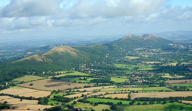
The Malvern Hills
摘要
[编辑]
| 描述 |
English: The Malvern Hills located in the English counties of Worcestershire and Herefordshire. The hills have been designated by the Countryside Agency as an Area of Outstanding Natural Beauty. The highest point is the Worcestershire Beacon at 425 metres (1,394 ft) above sea level. The range is a natural border between Worcestershire and Herefordshire. |
| 日期 | |
| 来源 |
https://www.flickr.com/photos/davidchief/2765256316/
|
| 作者 | David Martyn Hunt |
| 相机位置 | | 在以下服务上查看本图像和附近其他图像: OpenStreetMap |
|---|
许可协议
[编辑]
| 此张图片原发布于Flickr,在2012年3月4日由管理员或审查员Materialscientist检查后,确认检查时图片在Flickr的版权声明与维基共享资源的版权使用方针相符。 |
| 註解 | 該圖片含有註解:在維基媒體共享資源上查看註解 |

|
根据最有价值图像标准,这张图像被评定为在Malvern Hills, England范畴内最有价值的共享资源图像。你可以在Commons:Valued image candidates/Malvern Hills - England.jpg参看它的提名。 |
文件历史
点击某个日期/时间查看对应时刻的文件。
| 日期/时间 | 缩略图 | 大小 | 用户 | 备注 | |
|---|---|---|---|---|---|
| 当前 | 2023年4月24日 (一) 16:41 | | 3,656 × 2,119(2.41 MB) | Artanisen(留言 | 贡献) | Highest quality (same source) |
| 2012年3月4日 (日) 12:53 |  | 1,003 × 577(603 KB) | MrPanyGoff(留言 | 贡献) | cropped blown clouds | |
| 2012年3月4日 (日) 12:35 |  | 1,003 × 658(635 KB) | MrPanyGoff(留言 | 贡献) |
您不可以覆盖此文件。
文件用途
以下6个页面使用本文件:
全域文件用途
以下其他wiki使用此文件:
- arz.wikipedia.org上的用途
- ceb.wikipedia.org上的用途
- de.wikipedia.org上的用途
- de.wikivoyage.org上的用途
- en.wikipedia.org上的用途
- en.wikivoyage.org上的用途
- fa.wikipedia.org上的用途
- fr.wikipedia.org上的用途
- he.wikipedia.org上的用途
- io.wikipedia.org上的用途
- is.wikipedia.org上的用途
- it.wikivoyage.org上的用途
- mg.wikipedia.org上的用途
- pl.wikipedia.org上的用途
- tr.wikipedia.org上的用途
- www.wikidata.org上的用途
- zh.wikipedia.org上的用途