File:Malvern Hills - England.jpg
跳至導覽
跳至搜尋

預覽大小:800 × 464 像素。 其他解析度:320 × 185 像素 | 640 × 371 像素 | 1,024 × 594 像素 | 1,280 × 742 像素 | 2,560 × 1,484 像素 | 3,656 × 2,119 像素。
原始檔案 (3,656 × 2,119 像素,檔案大小:2.41 MB,MIME 類型:image/jpeg)
說明
說明
添加單行說明來描述出檔案所代表的內容
The Malvern Hills
摘要
[編輯]
| 描述 |
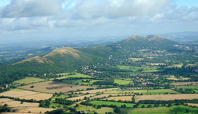
English: The Malvern Hills located in the English counties of Worcestershire and Herefordshire. The hills have been designated by the Countryside Agency as an Area of Outstanding Natural Beauty. The highest point is the Worcestershire Beacon at 425 metres (1,394 ft) above sea level. The range is a natural border between Worcestershire and Herefordshire. |
| 日期 | |
| 來源 |
https://www.flickr.com/photos/davidchief/2765256316/
|
| 作者 | David Martyn Hunt |
| 拍攝地點 | | 位於此地的本圖片與其他圖片: OpenStreetMap |
|---|
授權條款
[編輯]
| This image, originally posted to Flickr, was reviewed on 4 March 2012 by the administrator or reviewer Materialscientist, who confirmed that it was available on Flickr under the stated license on that date. |
此檔案採用創用CC 姓名標示 2.0 通用版授權條款。
- 您可以自由:
- 分享 – 複製、發佈和傳播本作品
- 重新修改 – 創作演繹作品
- 惟需遵照下列條件:
- 姓名標示 – 您必須指名出正確的製作者,和提供授權條款的連結,以及表示是否有對內容上做出變更。您可以用任何合理的方式來行動,但不得以任何方式表明授權條款是對您許可或是由您所使用。
| 註解 | 該圖片含有註解:在維基媒體共享資源上查看註解 |

|
根據最有價值圖像標準,這張圖像被評定为在Malvern Hills, England範疇內最有價值的共享資源圖像。你可以在Commons:Valued image candidates/Malvern Hills - England.jpg参看它的提名。 |
檔案歷史
點選日期/時間以檢視該時間的檔案版本。
| 日期/時間 | 縮圖 | 尺寸 | 用戶 | 備註 | |
|---|---|---|---|---|---|
| 目前 | 2023年4月24日 (一) 16:41 | | 3,656 × 2,119(2.41 MB) | Artanisen(對話 | 貢獻) | Highest quality (same source) |
| 2012年3月4日 (日) 12:53 |  | 1,003 × 577(603 KB) | MrPanyGoff(對話 | 貢獻) | cropped blown clouds | |
| 2012年3月4日 (日) 12:35 |  | 1,003 × 658(635 KB) | MrPanyGoff(對話 | 貢獻) |
無法覆蓋此檔案。
檔案用途
下列6個頁面有用到此檔案:
全域檔案使用狀況
以下其他 wiki 使用了這個檔案:
- arz.wikipedia.org 的使用狀況
- ceb.wikipedia.org 的使用狀況
- de.wikipedia.org 的使用狀況
- de.wikivoyage.org 的使用狀況
- en.wikipedia.org 的使用狀況
- en.wikivoyage.org 的使用狀況
- fa.wikipedia.org 的使用狀況
- fr.wikipedia.org 的使用狀況
- he.wikipedia.org 的使用狀況
- id.wikipedia.org 的使用狀況
- io.wikipedia.org 的使用狀況
- is.wikipedia.org 的使用狀況
- it.wikivoyage.org 的使用狀況
- mg.wikipedia.org 的使用狀況
- pl.wikipedia.org 的使用狀況
- tr.wikipedia.org 的使用狀況
- www.wikidata.org 的使用狀況
- zh.wikipedia.org 的使用狀況