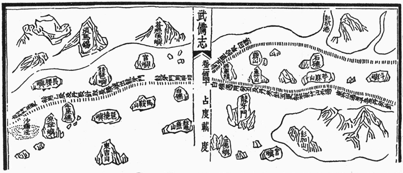
File:Mao Kun map - Singapore.png
来自Wikimedia Commons
跳转到导航
跳转到搜索

本预览的尺寸:799 × 344像素。 其他分辨率:320 × 138像素 | 640 × 276像素 | 1,289 × 555像素。
原始文件 (1,289 × 555像素,文件大小:473 KB,MIME类型:image/png)
文件信息
结构化数据
说明
说明
添加一行文字以描述该文件所表现的内容
摘要
[编辑]| 描述Mao Kun map - Singapore.png |
English: A Mao Kun map showing Singapore and part of the east coast of the Malay peninsula. Temasek (early Singapore; " 淡馬錫 ) is marked at the top left corner, others identified by Wheatley are Pulau Brani (琵琶嶼), Blakang Mati (長腰嶼, Sentosa), Pedra Branca (白礁), Pulau Tinggi (將軍帽), Pulau Aur (東竹山 and 西竹山), Pahang River estuary (彭杭港), and Pulau Tioman (苧麻山). Long Ya Men (龍牙門) on the map is said to mark the entrance to Keppel Harbour. Note that different sources may identify the islands differently, especially the islands of Singapore. J. V. G. Mills for example identified 長腰嶼 as Pulau Satumu and 琵琶嶼 as Pulau Sakijang Pelepah. |
| 日期 |
17世纪 date QS:P,+1650-00-00T00:00:00Z/7 |
| 来源 | Scanned from Paul Wheatley (1961年) 《 The Golden Khersonese: Studies in the Historical Geography of the Malay Peninsula before A.D. 1500》、吉隆坡: University of Malaya Press 联机电脑图书馆中心: 504030596. Originally from the Wubei Zhi (Treatise on Armament Technology), a 17th century work with maps based on material dated to the voyages of Zheng He (early 15th century). |
| 作者 | Mao Yuanyi (1594–1640?), editor of the Wubei Zhi; and an unknown cartographer. |
许可协议
[编辑]|
这是一个平面公有领域艺术品的忠实摄影副本。原艺术品本身因为下列原因属于公有领域:
维基媒体基金会的官方立场认为:“对平面公有领域艺术品的忠实再制作品也属于公有领域。”
因此,可以认为此摄影副本在美国也属于公有领域。在其他司法管辖区,再利用此内容可能存在限制;参见再利用PD-Art照片了解详细信息。 | |||||
文件历史
点击某个日期/时间查看对应时刻的文件。
| 日期/时间 | 缩略图 | 大小 | 用户 | 备注 | |
|---|---|---|---|---|---|
| 当前 | 2015年7月30日 (四) 14:42 |  | 1,289 × 555(473 KB) | Hzh(留言 | 贡献) | User created page with UploadWizard |
您不可以覆盖此文件。
文件用途
没有页面使用本文件。
全域文件用途
以下其他wiki使用此文件:
- cs.wikipedia.org上的用途
- en.wikipedia.org上的用途
- id.wikipedia.org上的用途
- it.wikipedia.org上的用途
- ko.wikipedia.org上的用途
- ms.wikipedia.org上的用途
- ru.wikipedia.org上的用途
- ta.wikipedia.org上的用途
- th.wikipedia.org上的用途
- tl.wikipedia.org上的用途
- uk.wikipedia.org上的用途
- zh.wikipedia.org上的用途
元数据
此文件含有额外信息,这些信息可能是创建或数字化该文件时使用的数码相机或扫描仪所添加的。如果文件已从其原始状态修改,某些详细信息可能无法完全反映修改后的文件。
| 水平分辨率 | 37.8 dpc |
|---|---|
| 垂直分辨率 | 37.8 dpc |
| 文件修改日期时间 | 2015年7月30日 (四) 12:55 |