File:Map-position-runavikar-kommuna-2009.png
跳至導覽
跳至搜尋

預覽大小:450 × 600 像素。 其他解析度:180 × 240 像素 | 600 × 800 像素。
原始檔案 (600 × 800 像素,檔案大小:33 KB,MIME 類型:image/png)
說明
說明
添加單行說明來描述出檔案所代表的內容
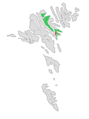
Location map of Runavík Municipality
摘要
[編輯]
| 描述 |
English: Location of Runavíkar kommuna at the Faroe Islands, with borders as of 2009.
Norsk bokmål: Plassering av Runavíkar kommuna på Færøyene, med grensene av 2009. |
| 日期 | |
| 來源 | Own work, based on free image by Arne List |
| 作者 | Erik Fløan |
| 其他版本 | Original (2005 edition) |
授權條款
[編輯]
| 我,此作品的版權所有人,釋出此作品至公共領域。此授權條款在全世界均適用。 這可能在某些國家不合法,如果是的話: 我授予任何人有權利使用此作品於任何用途,除受法律約束外,不受任何限制。 |
檔案歷史
點選日期/時間以檢視該時間的檔案版本。
| 日期/時間 | 縮圖 | 尺寸 | 用戶 | 備註 | |
|---|---|---|---|---|---|
| 目前 | 2009年1月2日 (五) 21:12 | | 600 × 800(33 KB) | Efloean(對話 | 貢獻) | {{Information |Description={{en|1=Location of Runavíkar kommuna at the Faroe Islands, with borders as of 2009.}} {{no|1=Plassering av Runavíkar kommuna på Færøyene, med grensene av 2009.}} |Source=Own work, based on free image by [[user:Arne List|Arn |
無法覆蓋此檔案。
檔案用途
下列2個頁面有用到此檔案:
全域檔案使用狀況
以下其他 wiki 使用了這個檔案:
- ca.wikipedia.org 的使用狀況
- da.wikipedia.org 的使用狀況
- el.wikipedia.org 的使用狀況
- en.wikipedia.org 的使用狀況
- es.wikipedia.org 的使用狀況
- eu.wikipedia.org 的使用狀況
- fo.wikipedia.org 的使用狀況
- fr.wikipedia.org 的使用狀況
- gv.wikipedia.org 的使用狀況
- hu.wikipedia.org 的使用狀況
- it.wikipedia.org 的使用狀況
- no.wikipedia.org 的使用狀況
- pl.wikipedia.org 的使用狀況
- ro.wikipedia.org 的使用狀況
- ru.wikipedia.org 的使用狀況
- sco.wikipedia.org 的使用狀況
- sv.wikipedia.org 的使用狀況
- tr.wikipedia.org 的使用狀況
- www.wikidata.org 的使用狀況
- zh.wikipedia.org 的使用狀況