File:Map Bolivia territorial loss-en.svg
ნავიგაციაზე გადასვლა
ძიებაზე გადასვლა

ამ SVG ფაილის PNG წინასწარი გადახედვის ზომაა: 375 × 355 პიქსელი. სხვა გაფართოება: 254 × 240 პიქსელი | 507 × 480 პიქსელი | 811 × 768 პიქსელი | 1 082 × 1 024 პიქსელი | 2 163 × 2 048 პიქსელი.
თავდაპირველი ფაილი (ფაილი SVG, ნომინალურად 375 × 355 პიქსელი, ფაილის ზომა: 78 კბ)
Captions
Captions
Add a one-line explanation of what this file represents
| აღწერა |
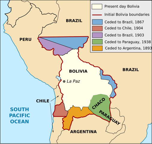
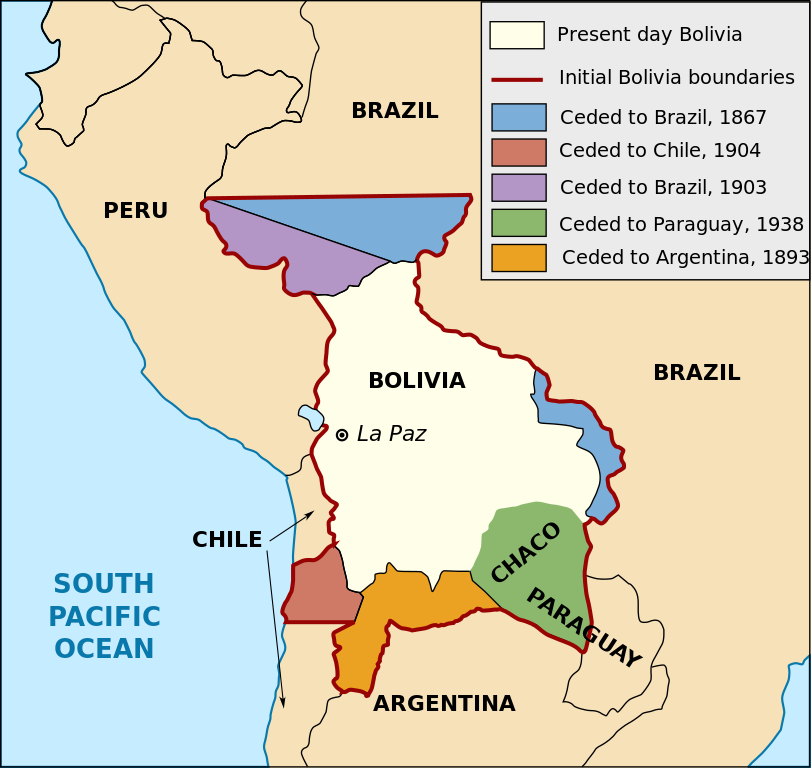
English: Territorial loss map of Bolivia |
| თარიღი | (UTC) |
| წყარო | |
| ავტორი |
|
| სხვა ვერსიები |
[]
Derivative works of this file: |


This work is in the public domain in the United States because it is a work prepared by an officer or employee of the United States Government as part of that person’s official duties under the terms of Title 17, Chapter 1, Section 105 of the US Code.
Note: This only applies to original works of the Federal Government and not to the work of any individual U.S. state, territory, commonwealth, county, municipality, or any other subdivision. This template also does not apply to postage stamp designs published by the United States Postal Service since 1978. (See § 313.6(C)(1) of Compendium of U.S. Copyright Office Practices). It also does not apply to certain US coins; see The US Mint Terms of Use.
|
 | |
| This file has been identified as being free of known restrictions under copyright law, including all related and neighboring rights. | ||
ფაილის ისტორია
დააწკაპუნეთ თარიღზე/დროზე, რათა იხილოთ ფაილი, როგორც ის მაშინ გამოიყურებოდა.
| თარიღი/დრო | მინიატიურა | განზომილებები | მომხმარებელი | კომენტარი | |
|---|---|---|---|---|---|
| მიმდინარე | 16:19, 1 იანვარი 2020 | | 375 × 355 (78 კბ) | Janitoalevic (განხილვა | წვლილი) | Added territory ceded to Argentina |
| 18:48, 12 დეკემბერი 2013 |  | 375 × 355 (68 კბ) | Pethrus (განხილვა | წვლილი) | Fixed ocean name | |
| 16:07, 4 მაისი 2010 |  | 375 × 355 (68 კბ) | Naturals (განხილვა | წვლილი) | The territory of Paraguay was reversed with the territory of Brazil | |
| 19:06, 3 მაისი 2010 |  | 375 × 355 (69 კბ) | Pethrus (განხილვა | წვლილი) | Paraguay border fixed | |
| 19:02, 3 მაისი 2010 |  | 375 × 355 (69 კბ) | Pethrus (განხილვა | წვლილი) | Fixed bugs | |
| 18:56, 3 მაისი 2010 |  | 375 × 355 (79 კბ) | Pethrus (განხილვა | წვლილი) | Inkscape bugs fixed | |
| 18:53, 3 მაისი 2010 |  | 375 × 355 (81 კბ) | Pethrus (განხილვა | წვლილი) | {{Information |Description={{en|Territorial loss map of Bolivia}} |Source=*File:Bolivia_territorial_loss_map_LOC.jpg |Date=2010-05-03 18:51 (UTC) |Author=*File:Bolivia_territorial_loss_map_LOC.jpg: Library of Congress Country Study on Bolivia |
თქვენ არ შეგიძლიათ ამ ფაილზე გადაწერა.
ფაილის გამოყენება
მომდევნო გვერდები იყენებენ ამ ფაილს:
- Atlas of Bolivia
- File:Bolivia territorial loss map LOC.svg (ფაილის გადამისამართება)
- File:Map Bolivia territorial loss-en.jpg
- File:Map Bolivia territorial loss-en.svg
- File:Map Bolivia territorial loss-es.svg
- File:Map Bolivia territorial loss-fr.svg
- File:Map Bolivia territorial loss-mk.svg
- File:Територијални губици Боливије-hu.svg
- File:Територијални губици Боливије.svg
- Template:Other versions/Map Bolivia territorial loss
ფაილის გლობალური გამოყენება
ეს ფაილი გამოიყენება შემდეგ ვიკებში:
- გამოყენება az.wikipedia.org-ში
- გამოყენება ca.wikipedia.org-ში
- გამოყენება cs.wikipedia.org-ში
- გამოყენება da.wikipedia.org-ში
- გამოყენება de.wikipedia.org-ში
- გამოყენება en.wikipedia.org-ში
- გამოყენება eu.wikipedia.org-ში
- გამოყენება fi.wikipedia.org-ში
- გამოყენება fr.wikipedia.org-ში
- გამოყენება hi.wikipedia.org-ში
- გამოყენება hi.wiktionary.org-ში
- გამოყენება id.wikipedia.org-ში
- გამოყენება it.wikipedia.org-ში
- გამოყენება ja.wikipedia.org-ში
- გამოყენება ka.wikipedia.org-ში
- გამოყენება ko.wikipedia.org-ში
- გამოყენება lt.wikipedia.org-ში
- გამოყენება nl.wikipedia.org-ში
- გამოყენება pl.wikipedia.org-ში
- გამოყენება pt.wikipedia.org-ში
- გამოყენება sat.wikipedia.org-ში
- გამოყენება sd.wikipedia.org-ში
- გამოყენება sk.wikipedia.org-ში
- გამოყენება te.wikipedia.org-ში
- გამოყენება zh.wikipedia.org-ში