File:Map Crusader states 1135-nl.svg
Salta a la navegació
Salta a la cerca

Mida d'aquesta previsualització PNG del fitxer SVG: 441 × 600 píxels. Altres resolucions: 176 × 240 píxels | 353 × 480 píxels | 565 × 768 píxels | 753 × 1.024 píxels | 1.506 × 2.048 píxels | 978 × 1.330 píxels.
Fitxer original (fitxer SVG, nominalment 978 × 1.330 píxels, mida del fitxer: 654 Ko)
Llegendes
Llegendes
Afegeix una explicació d'una línia del que representa aquest fitxer
Resum[modifica]
| Descripció |
[]
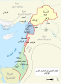
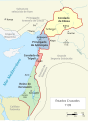
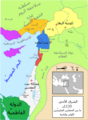
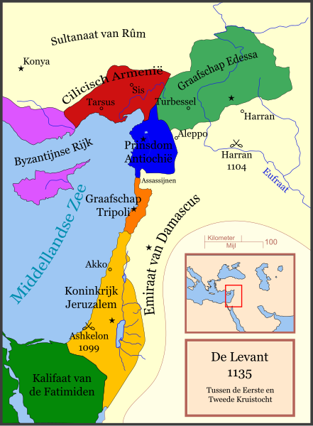
Čeština: Politická mapa Blízkého východu v roce 1135. Deutsch: Die Levante, 1135, zwischen den Ersten und Zweiten Kreuzzügen. Kreuzzugsstaaten sind mit einem roten Kreuz gekennzeichnet Eesti: Lähis-Ida (1135) Español: Oriente Próximo en 1135, entre la primera y segunda cruzadas. Esperanto: Politika mapo de Levantenio dum 1135, inter la krucmilitaroj unuaj kaj duaj. Français : Carte politique du Proche-Orient en 1135, entre la Première et la Seconde Croisades. les États latins d'Orient sont marqués d'une croix rouge. Galego: Mapa dos estados cruzados en Próximo Oriente polo 1135. Italiano: Carta politica del Vicino Oriente nel 1135. Magyar: A Közel-Kelet térképe 1135-ben. Polski: Mapa polityczna Bliskiego Wschodu w roku 1135, w okresie II krucjaty. Ελληνικά: Πολιτικός χάρτης της Μέσης Ανατολής το 1135, ανάμεσα στην πρώτη και τη δεύτερη Σταυροφορία Македонски: Политичка карта на Блискиот Исток во 1135 г. Крстоносните држави се означени со црвени крстови. Русский: Карта Ближнего Востока в 1135 г. Српски / srpski: Politička karta Bliskog Istoka 1135. godine, između Prvog i Drugog krstaškog pohoda. Krstaške države su označene crvenim krstom. ქართული: ახლო აღმოსავლეთი 1135 წელს ไทย: แผนที่ตะวันออกกลาง (คศ. 1135) ระหว่างครูเสดครั้งที่ 1 และครั่งที่ 2 中文: 一副关于1135年近东地区局势的地图,标注红色十字的为十字军国家 العربية : الدويلات الصليبية والدول الإسلامية المجاورة لها في الفترة بين الحملتين الصليبيتين الأولى والثانية. فارسی : نسخه فارسی Cap descripció.
|
||||||||||||||
| Data | 7 de març de 2008 (original upload date) | ||||||||||||||
| Font | No machine-readable source provided. Own work assumed (based on copyright claims). | ||||||||||||||
| Autor | No machine-readable author provided. Stuntelaar~commonswiki assumed (based on copyright claims). | ||||||||||||||
References[modifica]
- Bjorklund, Oddvar; Holmboe, Haakon; Rohr, Anders (1970) Historical Atlas of the World, Barnes & Noble, NY, SBN: 389-00253-4.
- Asia Minor and the Crusader states, c. 1140 from Findlay, Alexander G. (1849) Classical Atlas of Ancient Geography.
- Map of the Crusader states from Muir's Historical Atlas (1911)
- Eine Karte aus Putzgers, Historischer Schul-Atlas 39. Auflage. 1917. Tafel 16.
Other versions[modifica]
[]
-
 العربية
 -
 català
 -
 čeština (txec)
 -
 Deutsch (alemany)
 -
 English (anglès) (original)
 -
 Esperanto (esperanto)
 -
 español (espanyol) (1)
 -
 español (espanyol) (2)
 -
 eesti (estonià) (PNG)
 -
 français (francès) (1)
 -
 français (francès) (2)
 -
 galego (gallec) (1)
 -
 Bahasa Indonesia
 -
 italiano (italià) (PNG)
 -
 magyar (hongarès)
 -
 日本語 (japonès) (PNG)
 -
 Nederlands (neerlandès)
 -
 polski (polonès)
 -
 português (portuguès)
 -
 македонски (macedoni)
 -
 русский (rus)
 -
 Ελληνικά (grec)
 -
 հայերեն (armeni)
 -
 ქართული (georgià) (PNG)
 -
 中文 (xinès)
 -
 العربية (àrab) (PNG)
 -
 فارسی (persa) (PNG)


-ka.png)


See also[modifica]
Llicència[modifica]
Jo, el titular dels drets d'autor d'aquest treball, el public sota la següent llicència:

|
S'autoritza la còpia, la distribució i la modificació d'aquest document sota els termes de la llicència de documentació lliure GNU versió 1.2 o qualsevol altra versió posterior que publiqui la Free Software Foundation; sense seccions invariants, ni textos de portada, ni textos de contraportada. S'inclou una còpia d'aquesta llicència en la secció titulada GNU Free Documentation License. |
| Aquest fitxer està subjecte a la llicència de Creative Commons Reconeixement i Compartir Igual 3.0 No adaptada. | ||
| ||
| Aquest avís de llicència s'ha afegit a aquest fitxer d'acord amb l'actualització de la llicència GFDL. |
Historial del fitxer
Cliqueu una data/hora per veure el fitxer tal com era aleshores.
| Data/hora | Miniatura | Dimensions | Usuari/a | Comentari | |
|---|---|---|---|---|---|
| actual | 21:39, 7 jul 2010 | | 978 × 1.330 (654 Ko) | Malus Catulus (discussió | contribucions) | Converted text to path |
| 18:59, 7 març 2008 |  | 978 × 1.330 (104 Ko) | Stuntelaar~commonswiki (discussió | contribucions) | == Summary == {{de|Die Levante, 1135, zwischen den Ersten und Zweiten Kreuzzügen.}} {{en|A political map of the w:en:Near East in 1135 CE.}} {{fr|Carte politique du Proche-Orient en 1135, en |
No podeu sobreescriure aquest fitxer.
Ús del fitxer
Les 29 pàgines següents utilitzen aquest fitxer:
- File:Crusader States (1135)-ka.png
- File:Levant 1135-nl.svg (fitxer redirigit)
- File:Lähis-Ida 1135.png
- File:Map Crusader states 1135-ar.png
- File:Map Crusader states 1135-cs.svg
- File:Map Crusader states 1135-de.svg
- File:Map Crusader states 1135-de2.svg
- File:Map Crusader states 1135-el.svg
- File:Map Crusader states 1135-en.svg
- File:Map Crusader states 1135-eo.svg
- File:Map Crusader states 1135-es.svg
- File:Map Crusader states 1135-es2.svg
- File:Map Crusader states 1135-fr.svg
- File:Map Crusader states 1135-fr2.svg
- File:Map Crusader states 1135-hu.svg
- File:Map Crusader states 1135-hy.svg
- File:Map Crusader states 1135-it.png
- File:Map Crusader states 1135-jp.png
- File:Map Crusader states 1135-mk.svg
- File:Map Crusader states 1135-nl.svg
- File:Map Crusader states 1135-pl.png
- File:Map Crusader states 1135-pl.svg
- File:Map Crusader states 1135-pt.svg
- File:Map Crusader states 1135-ru.svg
- File:Map Crusader states 1135-zh.svg
- File:Map Crusads states 1135-fa.png
- File:The Crusader States in 1135-ar.svg
- File:The Crusader States in 1135.svg
- Template:Other versions/Map Crusader states 1135
Ús global del fitxer
Utilització d'aquest fitxer en altres wikis:
- Utilització a fy.wikipedia.org
- Utilització a nl.wikipedia.org
Categories:
- Maps showing 12th-century history
- Maps of the history of the Middle East
- Maps of the crusades
- Maps of the Kingdom of Jerusalem
- Maps of the County of Tripoli
- Maps of the Principality of Antioch
- Maps of Cilicia
- Maps of the County of Edessa
- Maps of the history of Cyprus
- Maps of the history of the Levant
- Dutch-language SVG maps showing history
- Derivative maps of Putzgers Historischer Schul-Atlas