File:Map Crusader states 1135-nl.svg
Aller à la navigation
Aller à la recherche

Taille de cet aperçu PNG pour ce fichier SVG : 441 × 600 pixels. Autres résolutions : 176 × 240 pixels | 353 × 480 pixels | 565 × 768 pixels | 753 × 1 024 pixels | 1 506 × 2 048 pixels | 978 × 1 330 pixels.
Fichier d’origine (Fichier SVG, nominalement de 978 × 1 330 pixels, taille : 654 kio)
Légendes
Légendes
Ajoutez en une ligne la description de ce que représente ce fichier
Description
[modifier]| Description |
[]
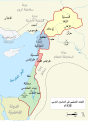
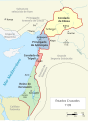
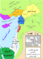
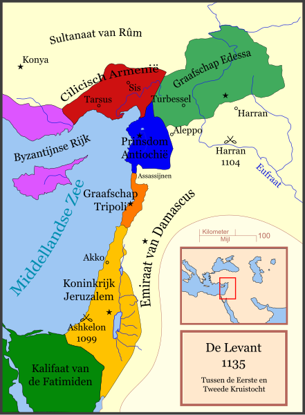
Čeština: Politická mapa Blízkého východu v roce 1135. Deutsch: Die Levante, 1135, zwischen den Ersten und Zweiten Kreuzzügen. Kreuzzugsstaaten sind mit einem roten Kreuz gekennzeichnet Eesti: Lähis-Ida (1135) Español: Oriente Próximo en 1135, entre la primera y segunda cruzadas. Esperanto: Politika mapo de Levantenio dum 1135, inter la krucmilitaroj unuaj kaj duaj. Français : Carte politique du Proche-Orient en 1135, entre la Première et la Seconde Croisades. les États latins d'Orient sont marqués d'une croix rouge. Galego: Mapa dos estados cruzados en Próximo Oriente polo 1135. Italiano: Carta politica del Vicino Oriente nel 1135. Magyar: A Közel-Kelet térképe 1135-ben. Polski: Mapa polityczna Bliskiego Wschodu w roku 1135, w okresie II krucjaty. Ελληνικά: Πολιτικός χάρτης της Μέσης Ανατολής το 1135, ανάμεσα στην πρώτη και τη δεύτερη Σταυροφορία Македонски: Политичка карта на Блискиот Исток во 1135 г. Крстоносните држави се означени со црвени крстови. Русский: Карта Ближнего Востока в 1135 г. Српски / srpski: Politička karta Bliskog Istoka 1135. godine, između Prvog i Drugog krstaškog pohoda. Krstaške države su označene crvenim krstom. ქართული: ახლო აღმოსავლეთი 1135 წელს ไทย: แผนที่ตะวันออกกลาง (คศ. 1135) ระหว่างครูเสดครั้งที่ 1 และครั่งที่ 2 中文: 一副关于1135年近东地区局势的地图,标注红色十字的为十字军国家 العربية : الدويلات الصليبية والدول الإسلامية المجاورة لها في الفترة بين الحملتين الصليبيتين الأولى والثانية. فارسی : نسخه فارسی Aucune description.
|
||||||||||||||
| Date | 7 mars 2008 (date de téléversement originale) | ||||||||||||||
| Source | La source n’a pas pu être reconnue automatiquement. « Travail personnel » supposé (étant donné la revendication de droit d’auteur). | ||||||||||||||
| Auteur | L’auteur n’a pas pu être identifié automatiquement. Il est supposé qu'il s'agit de : Stuntelaar~commonswiki (étant donné la revendication de droit d’auteur). | ||||||||||||||
References
[modifier]- Bjorklund, Oddvar; Holmboe, Haakon; Rohr, Anders (1970) Historical Atlas of the World, Barnes & Noble, NY, SBN: 389-00253-4.
- Asia Minor and the Crusader states, c. 1140 from Findlay, Alexander G. (1849) Classical Atlas of Ancient Geography.
- Map of the Crusader states from Muir's Historical Atlas (1911)
- Eine Karte aus Putzgers, Historischer Schul-Atlas 39. Auflage. 1917. Tafel 16.
Other versions
[modifier][]
-
 العربية
 -
 català
 -
 čeština (tchèque)
 -
 Deutsch (allemand)
 -
 English (anglais) (original)
 -
 Esperanto (espéranto)
 -
 español (espagnol) (1)
 -
 español (espagnol) (2)
 -
 eesti (estonien) (PNG)
 -
 français (français) (1)
 -
 français (français) (2)
 -
 galego (galicien) (1)
 -
 Bahasa Indonesia
 -
 italiano (italien) (PNG)
 -
 magyar (hongrois)
 -
 日本語 (japonais) (PNG)
 -
 Nederlands (néerlandais)
 -
 polski (polonais)
 -
 português (portugais)
 -
 македонски (macédonien)
 -
 русский (russe)
 -
 Ελληνικά (grec)
 -
 հայերեն (arménien)
 -
 ქართული (géorgien) (PNG)
 -
 中文 (chinois)
 -
 العربية (arabe) (PNG)
 -
 فارسی (persan) (PNG)


-ka.png)


See also
[modifier]
Conditions d’utilisation
[modifier]
Moi, en tant que détenteur des droits d’auteur sur cette œuvre, je la publie sous la licence suivante :

|
Vous avez la permission de copier, distribuer et modifier ce document selon les termes de la GNU Free Documentation License version 1.2 ou toute version ultérieure publiée par la Free Software Foundation, sans sections inaltérables, sans texte de première page de couverture et sans texte de dernière page de couverture. Un exemplaire de la licence est inclus dans la section intitulée GNU Free Documentation License. |
| Ce fichier est disponible selon les termes de la licence Creative Commons Attribution – Partage dans les Mêmes Conditions 3.0 (non transposée). | ||
| ||
| Ce bandeau de licence a été ajouté à ce fichier dans le cadre de la procédure de mise à jour des licences des images sous GFDL. |
Historique du fichier
Cliquer sur une date et heure pour voir le fichier tel qu'il était à ce moment-là.
| Date et heure | Vignette | Dimensions | Utilisateur | Commentaire | |
|---|---|---|---|---|---|
| actuel | 7 juillet 2010 à 21:39 | | 978 × 1 330 (654 kio) | Malus Catulus (d | contributions) | Converted text to path |
| 7 mars 2008 à 18:59 |  | 978 × 1 330 (104 kio) | Stuntelaar~commonswiki (d | contributions) | == Summary == {{de|Die Levante, 1135, zwischen den Ersten und Zweiten Kreuzzügen.}} {{en|A political map of the w:en:Near East in 1135 CE.}} {{fr|Carte politique du Proche-Orient en 1135, en |
Vous ne pouvez pas remplacer ce fichier.
Utilisations locales du fichier
Les 29 pages suivantes utilisent ce fichier :
- File:Crusader States (1135)-ka.png
- File:Levant 1135-nl.svg (redirection de fichier)
- File:Lähis-Ida 1135.png
- File:Map Crusader states 1135-ar.png
- File:Map Crusader states 1135-cs.svg
- File:Map Crusader states 1135-de.svg
- File:Map Crusader states 1135-de2.svg
- File:Map Crusader states 1135-el.svg
- File:Map Crusader states 1135-en.svg
- File:Map Crusader states 1135-eo.svg
- File:Map Crusader states 1135-es.svg
- File:Map Crusader states 1135-es2.svg
- File:Map Crusader states 1135-fr.svg
- File:Map Crusader states 1135-fr2.svg
- File:Map Crusader states 1135-hu.svg
- File:Map Crusader states 1135-hy.svg
- File:Map Crusader states 1135-it.png
- File:Map Crusader states 1135-jp.png
- File:Map Crusader states 1135-mk.svg
- File:Map Crusader states 1135-nl.svg
- File:Map Crusader states 1135-pl.png
- File:Map Crusader states 1135-pl.svg
- File:Map Crusader states 1135-pt.svg
- File:Map Crusader states 1135-ru.svg
- File:Map Crusader states 1135-zh.svg
- File:Map Crusads states 1135-fa.png
- File:The Crusader States in 1135-ar.svg
- File:The Crusader States in 1135.svg
- Template:Other versions/Map Crusader states 1135
Utilisations du fichier sur d’autres wikis
Les autres wikis suivants utilisent ce fichier :
- Utilisation sur fy.wikipedia.org
- Utilisation sur nl.wikipedia.org
Catégories :
- Maps showing 12th-century history
- Maps of the history of the Middle East
- Maps of the crusades
- Maps of the Kingdom of Jerusalem
- Maps of the County of Tripoli
- Maps of the Principality of Antioch
- Maps of Cilicia
- Maps of the County of Edessa
- Maps of the history of Cyprus
- Maps of the history of the Levant
- Dutch-language SVG maps showing history
- Derivative maps of Putzgers Historischer Schul-Atlas