File:Map Greece expansion 1832-1947-zhcn.svg
跳转到导航
跳转到搜索

此SVG文件的PNG预览的大小:457 × 599像素。 其他分辨率:183 × 240像素 | 366 × 480像素 | 586 × 768像素 | 781 × 1,024像素 | 1,562 × 2,048像素 | 734 × 962像素。
原始文件 (SVG文件,尺寸为734 × 962像素,文件大小:109 KB)
说明
说明
添加一行文字以描述该文件所表现的内容
| 描述 |
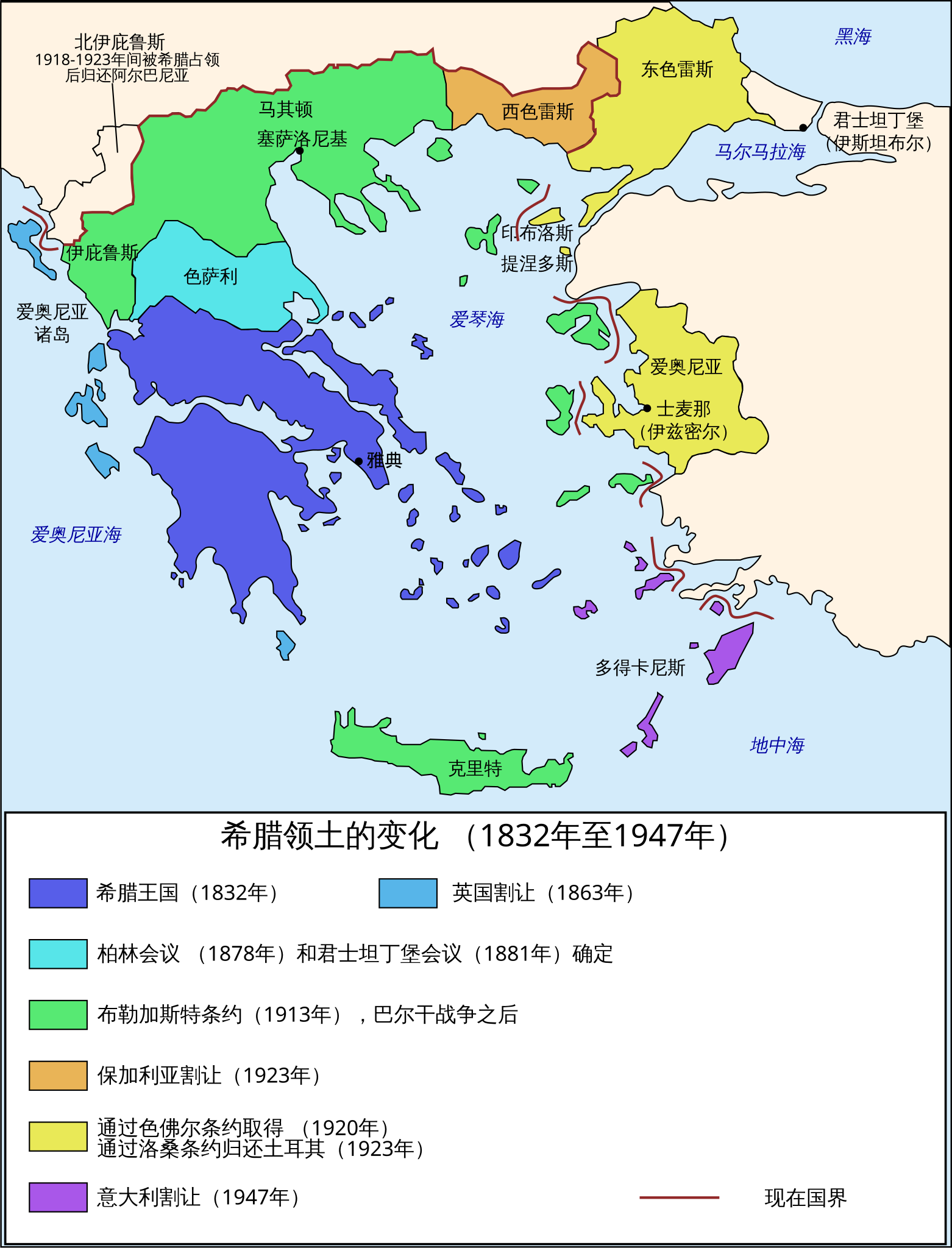
Čeština: Mapa zobrazuje územní expanzi Řeckého království (1832–1947). Dansk: Kort over Grækenlands territoriale udvidelser, 1832-1947. Deutsch: Territoriale Expansion Griechenlands 1832-1947. English: The territorial expansion of Greece, 1832-1947. Español: Mapa de la expansión territorial griega (1832-1947) Euskara: Greziaren lurralde hedapena 1832-1947 bitartean Français : L'expansion territoriale de la Grèce. 1832-1947. Hrvatski: Teritorijalno proširenje Grčke u razdoblju od 1832. do 1947. Italiano: L'espansione territoriale della Grecia dal 1832 al 1947 Magyar: Görögország területi növekedése (1832-1947) Occitan : Evolucions territòrialas de Grècia. Ελληνικά: Η εδαφική επέκταση της Ελλάδας 1832-1947. Македонски: Територијално проширување на Грција Українська: Територіальна експансія Греції (1832-1947). 日本語: ギリシャ王国の版図拡大 (1832-1947年) 中文: 希腊的领土变迁,1832年-1947年间。 العربية : خريطة تُصوِّر الأراضي التي استولت عليها اليونان مُنذُ سنة 1832م حين استقلالها عن الدولة العُثمانيَّة، وُصولًا إلى سنة 1947م |
||
| 日期 | (UTC) | ||
| 来源 | |||
| 作者 |
|
||
| 其他版本 |
[]
|


.PNG)


.png)


| 这是一张修改过的图片,这意味着它已在原版本的基础上通过软件进行了编辑,改动内容:Translated into simplified Chinese。其原始版本为:Map Greece expansion 1832-1947-en.svg。修改者:Extvia。
|
我,本作品著作权人,特此采用以下许可协议发表本作品:
| 本文件采用知识共享署名-相同方式共享 3.0 未本地化版本许可协议授权。 | ||
| ||
| 本许可协议标签作为GFDL许可协议更新的组成部分被添加至本文件。 |

|
已授权您依据自由软件基金会发行的无固定段落及封面封底文字(Invariant Sections, Front-Cover Texts, and Back-Cover Texts)的GNU自由文件许可协议1.2版或任意后续版本的条款,复制、传播和/或修改本文件。该协议的副本请见“GNU Free Documentation License”。 |
您可以选择您需要的许可协议。
原始上传日志
[编辑]
This image is a derivative work of the following images:
- File:Map_Greece_expansion_1832-1947-en.svg licensed with Cc-by-sa-3.0-migrated, GFDL
- 2008-12-05T14:46:53Z Future Perfect at Sunrise 734x962 (121736 Bytes) marked present border
- 2008-12-05T12:31:19Z Future Perfect at Sunrise 734x962 (112647 Bytes) corrected "Western Thrace"; tweaked some captions
- 2007-03-31T11:10:35Z Rursus 734x962 (112342 Bytes)
Uploaded with derivativeFX
文件历史
点击某个日期/时间查看对应时刻的文件。
| 日期/时间 | 缩略图 | 大小 | 用户 | 备注 | |
|---|---|---|---|---|---|
| 当前 | 2011年2月24日 (四) 12:44 | | 734 × 962(109 KB) | Extvia(留言 | 贡献) | {{Information |Description={{en|The territorial expansion of Greece, 1832-1947.}} {{zh|希腊的领土变迁,1832年-1947年间。}} |Source=*File:Map_Greece_expansion_1832-1947-en.svg |Date=2011-02-24 12:42 (UTC) |Author=*[[:File:Map_Greece_expan |
您不可以覆盖此文件。
文件用途
以下30个页面使用本文件:
- File:ExpansionofModernGreece.png
- File:Greek history from 1832-ar.png
- File:Greek history from 1832.GIF
- File:Greekhistory-zh-classical.png
- File:Greekhistory el.gif
- File:Grècia - Evolucions territòrialas.png
- File:La expansión territorial de Grecia (1832-1947).PNG
- File:Map Greece Megali Idea (hy).png
- File:Map Greece expansion 1832-1947-HE.svg
- File:Map Greece expansion 1832-1947-ar.svg
- File:Map Greece expansion 1832-1947-cs-2.svg
- File:Map Greece expansion 1832-1947-da.svg
- File:Map Greece expansion 1832-1947-el.svg
- File:Map Greece expansion 1832-1947-en.svg
- File:Map Greece expansion 1832-1947-es.svg
- File:Map Greece expansion 1832-1947-eu.png
- File:Map Greece expansion 1832-1947-fr.svg
- File:Map Greece expansion 1832-1947-he.svg
- File:Map Greece expansion 1832-1947-hr.svg
- File:Map Greece expansion 1832-1947-hu.svg
- File:Map Greece expansion 1832-1947-it.svg
- File:Map Greece expansion 1832-1947-mk.svg
- File:Map Greece expansion 1832-1947-nl.svg
- File:Map Greece expansion 1832-1947-sr.svg
- File:Map Greece expansion 1832-1947-zhcn.svg
- File:Map Greece expansion 1832-1947 ja.svg
- File:Territorial Expansion of Greece from 1832–1947.gif
- File:Επέκταση Ελλάδας 1832-1947.svg
- File:Територіальна експансія Греції в 1832-1947рр.png
- Template:Other versions/Map Greece expansion 1832-1947
全域文件用途
以下其他wiki使用此文件:
- wuu.wikipedia.org上的用途
- zh.wikipedia.org上的用途