File:Map Iberian Peninsula 910-es.svg
跳至導覽
跳至搜尋

此 SVG 檔案的 PNG 預覽的大小:800 × 556 像素。 其他解析度:320 × 223 像素 | 640 × 445 像素 | 1,024 × 712 像素 | 1,280 × 890 像素 | 2,560 × 1,781 像素 | 818 × 569 像素。
原始檔案 (SVG 檔案,表面大小:818 × 569 像素,檔案大小:622 KB)
說明
說明
添加單行說明來描述出檔案所代表的內容
摘要
[編輯]| 描述 |
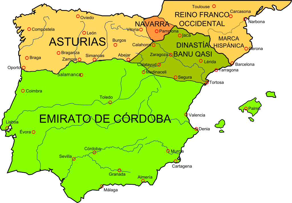
Deutsch: Landkarte der Iberischen Halbinsel im Jahr 910
English: Map of the Iberian Peninsula in 910
Español: Mapa de la península ibérica en el 910 |
| 日期 | |
| 來源 | File:España910.jpg from this map, liberated to the public domain by the University of Texas |
| 作者 | Crates |
| 其他版本 |
[]
See also[編輯]
|


授權條款
[編輯]
我,本作品的著作權持有者,決定用以下授權條款發佈本作品:

|
已授權您依據自由軟體基金會發行的無固定段落、封面文字和封底文字GNU自由文件授權條款1.2版或任意後續版本,對本檔進行複製、傳播和/或修改。該協議的副本列在GNU自由文件授權條款中。 |
This file is licensed under the Creative Commons Attribution-Share Alike Attribution-Share Alike 4.0 International, 3.0 Unported, 2.5 Generic, 2.0 Generic and 1.0 Generic license.
- 您可以自由:
- 分享 – 複製、發佈和傳播本作品
- 重新修改 – 創作演繹作品
- 惟需遵照下列條件:
- 姓名標示 – 您必須指名出正確的製作者,和提供授權條款的連結,以及表示是否有對內容上做出變更。您可以用任何合理的方式來行動,但不得以任何方式表明授權條款是對您許可或是由您所使用。
- 相同方式分享 – 如果您利用本素材進行再混合、轉換或創作,您必須基於如同原先的相同或兼容的條款,來分布您的貢獻成品。
您可以選擇您需要的授權條款。
檔案歷史
點選日期/時間以檢視該時間的檔案版本。
| 日期/時間 | 縮圖 | 尺寸 | 用戶 | 備註 | |
|---|---|---|---|---|---|
| 目前 | 2009年1月21日 (三) 16:24 | | 818 × 569(622 KB) | Xavigivax(對話 | 貢獻) | Elimino cuadrado negro. |
| 2009年1月20日 (二) 16:41 |  | 818 × 569(626 KB) | Phirosiberia(對話 | 貢獻) | {{Information |Description= |Source= |Date= |Author= |Permission= |other_versions= }} | |
| 2009年1月20日 (二) 16:38 |  | 827 × 574(632 KB) | Phirosiberia(對話 | 貢獻) | {{Information |Description= |Source= |Date= |Author= |Permission= |other_versions= }} | |
| 2009年1月20日 (二) 16:34 |  | 827 × 574(317 KB) | Phirosiberia(對話 | 貢獻) | {{Information |Description={{en|1=Map of the Iberian Peninsula in 910.}} {{es|1=Mapa de la península ibérica en el 910.}} |Source=Archivo:España910.jpg, that comes from [http://www.lib.utexas.edu/maps/historical/shepherd_1911/shepherd-c-082-083.jp |
無法覆蓋此檔案。
檔案用途
下列15個頁面有用到此檔案:
- Maps of Spain
- Reconquista
- File:España910.jpg
- File:Map Iberian Peninsula 910-bg.svg
- File:Map Iberian Peninsula 910-es.svg
- File:Map Iberian Peninsula 910-eu.svg
- File:Map Iberian Peninsula 910-hu.svg
- File:Map Iberian Peninsula 910-ru.svg
- File:Península ibérica 910.svg (檔案重新導向)
- Template:Other versions/Map Iberian Peninsula 910
全域檔案使用狀況
以下其他 wiki 使用了這個檔案:
- an.wikipedia.org 的使用狀況
- ar.wikipedia.org 的使用狀況
- ast.wikipedia.org 的使用狀況
- azb.wikipedia.org 的使用狀況
- bn.wikipedia.org 的使用狀況
- br.wikipedia.org 的使用狀況
- bs.wikipedia.org 的使用狀況
- ca.wikipedia.org 的使用狀況
- csb.wikipedia.org 的使用狀況
- cs.wikipedia.org 的使用狀況
- da.wikipedia.org 的使用狀況
- de.wikipedia.org 的使用狀況
- el.wikipedia.org 的使用狀況
- en.wikipedia.org 的使用狀況
- es.wikipedia.org 的使用狀況
- et.wikipedia.org 的使用狀況
- eu.wikipedia.org 的使用狀況
- fr.wikipedia.org 的使用狀況
檢視此檔案的更多全域使用狀況。
分類:
- Maps of the Kingdom of Asturias
- Maps of the Kingdom of Navarre
- Maps of the Emirate of Córdoba
- History of Catalonia
- Maps of the Frankish territory
- Maps of the history of Portugal
- Maps showing 10th-century history
- Spanish-language SVG maps showing history of Europe
- Territorial evolution of Spain
- Spain in the 910s