File:Map Italophone World - updated.png
跳至導覽
跳至搜尋

預覽大小:800 × 370 像素。 其他解析度:320 × 148 像素 | 640 × 296 像素 | 1,357 × 628 像素。
原始檔案 (1,357 × 628 像素,檔案大小:55 KB,MIME 類型:image/png)
說明
說明
添加單行說明來描述出檔案所代表的內容
Map of the Italophone World

|
本圖片是以PNG、GIF或JPEG格式上傳。然而,其中包含的資料或訊息,應該重新建立成可縮放向量圖形(SVG)檔案,以更有效率或更準確的方式儲存。如有可能,請上傳本圖片的SVG格式版本。在上傳之後,請修改維基各姊妹計畫中所有使用舊版圖片的條目(列在圖像連結章節中),替換為新版圖片,並在舊圖片的描述頁中加入{{Vector version available|新圖片名稱.svg}}模板,同時移除本模板。
|
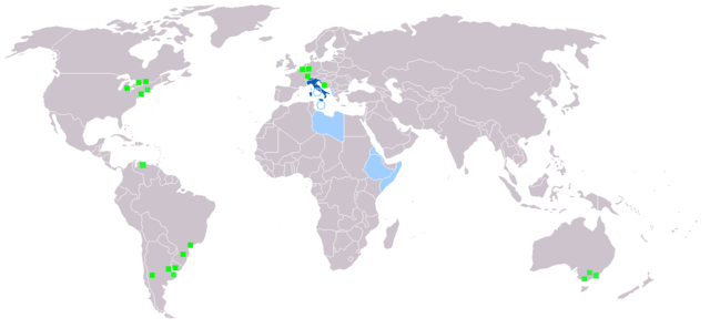
摘要[編輯]
Map made from Image:BlankMap-World.png
| 描述 |
Deutsch: Legende:
Muttersprache
Amtssprache
Zweit- oder nicht offizielle Sprache
Italienischsprachige Minderheiten English: Legend:
Native language
Administrative language
Secondary language or non-official.
Italophone minorities Español: Leyenda:
Lengua materna
Lengua administrativa
Segunda lengua o lengua no oficial.
Minorías italofonas Français : Carte du monde où on parle l'italien.
Langue maternelle
Langue administrative
Langue importante et/ou langue de culture
Minorités italophones Italiano: Legenda:
Lingua madre
Lingua amministrativa
Seconda lingua o lingua non ufficiale
Minoranze italofone Português: Legenda:
Idioma materno
Idioma administrativo
Idioma secundário, ou não-oficial
Minorias italófonas Polski: Legenda:
Włoski jest językiem ojczystym
Włoski jest językiem urzędowym
Włoski jest drugim lub nieoficjalnym językiem
Mniejszości włoskojęzyczne |
| 來源 | |
| 作者 |
授權條款[編輯]

|
已授權您依據自由軟體基金會發行的無固定段落、封面文字和封底文字GNU自由文件授權條款1.2版或任意後續版本,對本檔進行複製、傳播和/或修改。該協議的副本列在GNU自由文件授權條款中。 |
| 此檔案採用創用CC 姓名標示-相同方式分享 3.0 未在地化版本授權條款。 | ||
| ||
| 已新增授權條款標題至此檔案,作為GFDL授權更新的一部份。 |
檔案歷史
點選日期/時間以檢視該時間的檔案版本。
| 日期/時間 | 縮圖 | 尺寸 | 使用者 | 備註 | |
|---|---|---|---|---|---|
| 目前 | 2022年1月27日 (四) 19:40 | | 1,357 × 628(55 KB) | Jacob300(留言 | 貢獻) | Updated Somaliland - Italian was never an official language here |
| 2021年7月29日 (四) 18:25 |  | 1,357 × 628(29 KB) | MMMM fan(留言 | 貢獻) | Reverted to version as of 14:07, 3 July 2006 (UTC) Removing outdated or inaccurate Italophone minorities | |
| 2018年3月7日 (三) 09:36 |  | 1,357 × 628(36 KB) | Maphobbyist(留言 | 貢獻) | Montenegro and South Sudan borders | |
| 2014年2月5日 (三) 20:22 |  | 1,357 × 628(39 KB) | Mr. Lama(留言 | 貢獻) | {{SVG|map}} == {{int:filedesc}} == Map made from Image:BlankMap-World.png {{de|Legende: *Dunkelblau: Muttersprache *Blau: Amtssprache *Hellblau: Zweit- oder nicht offizielle Sprache *Grüne Quadrate: Italienischsprachige Minderheiten}} {{en|Lege... | |
| 2006年7月3日 (一) 14:07 |  | 1,357 × 628(29 KB) | Fsolda~commonswiki(留言 | 貢獻) | == Summary == Map made from Image:BlankMap-World.png {{en|Legend: *Dark blue: native language *Blue: administrative language *Light blue: Secondary language or non-official. *green square: italophone minorities}} {{es|Legenda: *azul oscuro: lengua |
無法覆蓋此檔案。
檔案用途
下列5個頁面有用到此檔案:
- User:Chumwa/OgreBot/Travel and communication maps/2018 March 1-10
- User:Chumwa/OgreBot/Travel and communication maps/2021 July 21-31
- User:Chumwa/OgreBot/Travel and communication maps/2022 January 21-31
- User:J budissin/Uploads/BiH/2018 March 1-10
- User:Magog the Ogre/Multilingual legend/2022 January 21-31
全域檔案使用狀況
以下其他 wiki 使用了這個檔案:
- ab.wikipedia.org 的使用狀況
- en.wikipedia.org 的使用狀況
- it.wikipedia.org 的使用狀況
- lv.wikipedia.org 的使用狀況
- nl.wikipedia.org 的使用狀況
- pnb.wikipedia.org 的使用狀況