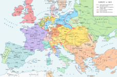
File:Map congress of vienna.jpg
Fra Wikimedia Commons
Spring til navigation
Spring til søgning
Map_congress_of_vienna.jpg (767 × 594 billedpunkter, filstørrelse: 325 KB, MIME-type: image/jpeg)
File information
Structured data
Captions
Captions
Tilføj en kort forklaring på en enkelt linje om hvad filen viser
Beskrivelse
[redigér]| BeskrivelseMap congress of vienna.jpg | Map of Europe, after the Congress of Vienna, 1815 |
| Dato | |
| Kilde | The International Commission and Association on Nobility. Add today 2015, nov.29 some details & corrections in the Austrian & Ottoman empires, according with « Grosser Atlas zur Weltgeschichte » (H.E.Stier, dir.) Westermann 1985, ISBN 3-14-100919-8, « Putzger historischer Weltatlas Cornelsen » 1990, ISBN 3-464-00176-8, « Atlas des Peuples » of André & Jean Sellier, ed. La Découverte : « Europe centrale » : 1992, ISBN 2-7071-2032-4 and « Orient » : 1993 and ISBN 2-7071-2222-X ; « Történelmi atlasz a középiskolák számára », Kartográfiai Vállalat Szerkesztőbizottsága, Budapest 1991, ISBN 963-351-422-3. |
| Forfatter | The International Commission and Association on Nobility |
| Tilladelse (Genbrug af denne fil) |
Disclaimer from the website of The International Commission and Association on Nobility: "The pictures are not copyrighted. All pictures we use are in the public domain." |
| Andre versioner |
Derivative works of this file: Map congress of vienna-fr.png |
Licensering
[redigér]| Public domainPublic domainfalsefalse |
| Jeg, indehaveren af ophavsretten til dette værk, udgiver dette værk som offentlig ejendom. Dette gælder i hele verden. I nogle lande er dette ikke juridisk muligt. I så fald: Jeg giver enhver ret til at anvende dette værk til ethvert formål, uden nogen restriktioner, medmindre sådanne restriktioner er påkrævede ved lov. |
Filhistorik
Klik på en dato/tid for at se filen som den så ud på det tidspunkt.
| Dato/tid | Miniaturebillede | Dimensioner | Bruger | Kommentar | |
|---|---|---|---|---|---|
| nuværende | 3. dec. 2015, 00:24 |  | 767 × 594 (325 KB) | Ras67 (diskussion | bidrag) | cropped |
| 29. nov. 2015, 17:34 |  | 775 × 600 (296 KB) | Spiridon Ion Cepleanu (diskussion | bidrag) | Add today 2015, nov.29 some details & corrections in the Austrian & Ottoman empires, according with « Grosser Atlas zur Weltgeschichte » (H.E.Stier, dir.) Westermann 1985, ISBN 3-14-100919-8, « Putzger historischer Weltatlas Cornelsen » 1990, ISBN... | |
| 3. apr. 2013, 16:58 |  | 775 × 600 (96 KB) | Lubiesque (diskussion | bidrag) | Map corrected. Luxembourg was part of the German Confederation. | |
| 20. nov. 2010, 17:48 |  | 1.292 × 1.000 (356 KB) | P. S. Burton (diskussion | bidrag) | {{Information |Description=Map of Europe, after the Congress of Vienna, 1815 |Source=[http://www.nobility-association.com/thecongressofvienna.htm The International Commission and Association on Nobility] |Date=2009 |Author=The International Commission and |
Du kan ikke overskrive denne fil.
Filanvendelse
De følgende 2 sider bruger denne fil:
Global filanvendelse
Følgende andre wikier anvender denne fil:
- Anvendelser på ar.wikipedia.org
- Anvendelser på az.wikipedia.org
- Anvendelser på bn.wikipedia.org
- Anvendelser på bn.wikibooks.org
- Anvendelser på ca.wikipedia.org
- Anvendelser på cs.wikipedia.org
- Anvendelser på da.wikipedia.org
- Anvendelser på en.wikipedia.org
- Anvendelser på en.wikibooks.org
- Anvendelser på eo.wikipedia.org
- Anvendelser på es.wikipedia.org
- Anvendelser på et.wikipedia.org
- Anvendelser på fi.wikipedia.org
- Anvendelser på fr.wikipedia.org
- Anvendelser på hi.wikipedia.org
- Anvendelser på hy.wikipedia.org
- Anvendelser på id.wikipedia.org
- Anvendelser på io.wikipedia.org
- Anvendelser på it.wikipedia.org
- Anvendelser på ja.wikipedia.org
- Anvendelser på ka.wikipedia.org
- Anvendelser på lv.wikipedia.org
- Anvendelser på ms.wikipedia.org
- Anvendelser på pl.wikipedia.org
- Anvendelser på ro.wikipedia.org
- Anvendelser på ru.wikipedia.org
- Anvendelser på sco.wikipedia.org
- Anvendelser på sh.wikipedia.org
- Anvendelser på sv.wikipedia.org
- Anvendelser på tr.wikipedia.org
- Anvendelser på uk.wikipedia.org
Vis flere globale anvendelser af denne fil.
Metadata
Denne fil indeholder yderligere informationer, sandsynligvis tilføjet af digitalkameraet eller den skanner som blev brugt til at oprette eller digitalisere den. Hvis filen er ændret fra sin oprindelige tilstand, afspejler nogle detaljer muligvis ikke den ændrede fil.
| Brugerkommentarer | rce: http://commons.wikimedia.org/wiki/File:Map_congress_of_vienna.jpg |
|---|---|
| Kameraretning | Normal |
| Vandret opløsning | 96 dpi |
| Lodret opløsning | 96 dpi |
| Software | Adobe Photoshop |
| Dato og tid for ændring af fil | 3. dec. 2015, 01:21 |
| Farverum | Ukalibreret |


