File:Map hamburg altona 1910.jpg
Zur Navigation springen
Zur Suche springen
Größe dieser Vorschau: 789 × 600 Pixel. Weitere Auflösungen: 316 × 240 Pixel | 632 × 480 Pixel | 1.011 × 768 Pixel | 1.280 × 973 Pixel | 2.605 × 1.980 Pixel.
Originaldatei (2.605 × 1.980 Pixel, Dateigröße: 1,62 MB, MIME-Typ: image/jpeg)
Bildtexte
Kurzbeschreibungen
Ergänze eine einzeilige Erklärung, was diese Datei darstellt.
Beschreibung[Bearbeiten]
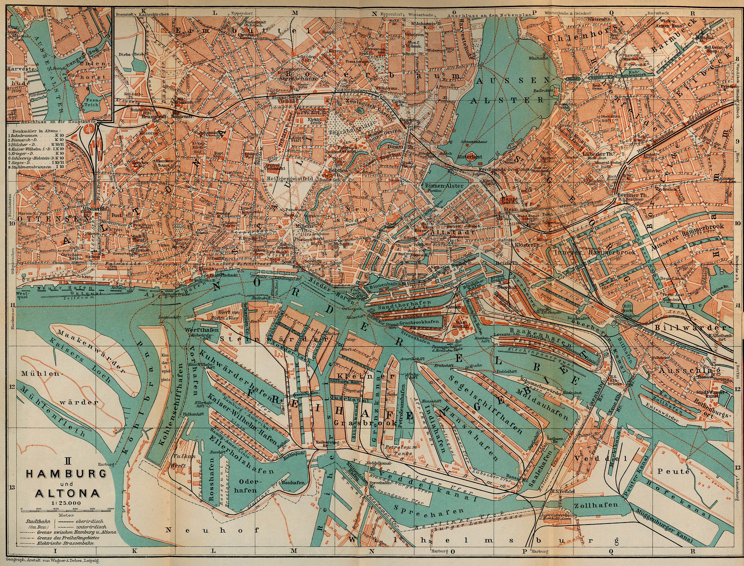
| Beschreibung | Map of Hamburg and Altona, Germany, 1910 |
| Datum | |
| Quelle | http://www.lib.utexas.edu/maps/historical/baedeker_n_germany_1910/hamburg_altona_1910.jpg, "Northern Germany as far as the Bavarian and Austrian Frontiers; Handbook for Travellers" by Karl Baedeker. Fifteenth Revised Edition. Leipzig, Karl Baedeker; New York, Charles Scribner's Sons 1910. "Courtesy of the University of Texas Libraries, The University of Texas at Austin." http://www.lib.utexas.edu/maps/map_sites/hist_sites.html |
| Urheber | |
| Andere Versionen |
Abgeleitete Werke dieser Datei: |
Lizenz[Bearbeiten]
Diese Mediendatei ist gemeinfrei in den Vereinigten Staaten. Dies gilt für US-amerikanische Werke, deren Urheberrecht erloschen ist, üblicherweise, weil ihre Erstveröffentlichung vor dem 1. Januar 1929 liegt. Genauere Erläuterungen hier.
|
 | |||
 |
Dieses Bild ist möglicherweise außerhalb der USA nicht gemeinfrei (dies gilt insbesondere in Kanada, China (jedoch nicht in Hongkong, Macao oder Taiwan), Deutschland, Mexiko und der Schweiz). Urheber und Veröffentlichungsjahr sind unverzichtbare Informationen, die angegeben werden müssen. Siehe Wikipedia:Public domain und Wikipedia:Copyrights für genauere Erläuterungen.
|

Dateiversionen
Klicke auf einen Zeitpunkt, um diese Version zu laden.
| Version vom | Vorschaubild | Maße | Benutzer | Kommentar | |
|---|---|---|---|---|---|
| aktuell | 08:24, 16. Mai 2009 | | 2.605 × 1.980 (1,62 MB) | Emma7stern (Diskussion | Beiträge) | Reverted to version as of 00:07, 23 April 2006 |
| 08:21, 16. Mai 2009 |  | 911 × 1.040 (1,1 MB) | Emma7stern (Diskussion | Beiträge) | ausschnitt | |
| 00:07, 23. Apr. 2006 |  | 2.605 × 1.980 (1,62 MB) | 700 MB (Diskussion | Beiträge) | {{Information| |Description=Map of Hamburg and Altona, Germany, 1910 |Source=http://www.lib.utexas.edu/maps/historical/baedeker_n_germany_1910/hamburg_altona_1910.jpg |Date=1910 |Author="Northern Germany as far as the Bavarian and Austrian Frontiers; Hand |
Du kannst diese Datei nicht überschreiben.
Dateiverwendung
Die folgenden 12 Seiten verwenden diese Datei:
- Hamburg
- File:Altonaer sheruw.jpg
- File:Hamburger Hafen 1910.jpg
- File:Janssen & schmilinsky.jpg
- File:Janssen & schmilinsky2.jpg
- File:Karte-holstenstraße-1910.jpg
- File:Karte Hamburger Hafen 1910.jpg
- File:Map-Altona Große Bergstraße.jpg
- File:Map port of hamburg 1910.jpg
- File:Reiherstiegwerft-karte1790-1910.jpg
- File:Schulterblatt schanzenviertel 1910.jpg
- File:Stülckenwerft.jpg
Globale Dateiverwendung
Die nachfolgenden anderen Wikis verwenden diese Datei:
- Verwendung auf ceb.wikipedia.org
- Verwendung auf de.wikipedia.org
- Verwendung auf en.wikipedia.org
- Verwendung auf fr.wikipedia.org
- Verwendung auf sv.wikipedia.org
- Verwendung auf www.wikidata.org
Metadaten
Kategorien:
- Parts of old maps of Hamburg
- Maps of Hamburg-Altona-Nord
- Maps of Hamburg-Altona-Altstadt
- Maps of Hamburg-Altstadt
- Maps of Hamburg-Barmbek-Süd
- Maps of Hamburg-Eilbek
- Maps of Hamburg-Eimsbüttel
- Maps of Hamburg-Hamm
- Maps of Hamburg-Hammerbrook
- Maps of Hamburg-Harvestehude
- Maps of Hamburg-Hohenfelde
- Maps of Hamburg-Kleiner Grasbrook
- Maps of Hamburg-Neustadt
- Maps of Hamburg-Ottensen
- Maps of Hamburg-Rothenburgsort
- Maps of Hamburg-Rotherbaum
- Maps of Hamburg-Sternschanze
- Maps of Hamburg-St. Georg
- Maps of Hamburg-St. Pauli
- Maps of Hamburg-Steinwerder
- Maps of Hamburg-Uhlenhorst
- Maps of Hamburg-Wilhelmsburg
- Maps of Hamburg-Veddel
- Hamburg in the 1910s
- Northern Germany as far as the Bavarian and Austrian frontiers (1910) by BAEDEKER