File:Map helgoland 1910.jpg
跳至導覽
跳至搜尋

預覽大小:470 × 599 像素。 其他解析度:188 × 240 像素 | 603 × 769 像素。
原始檔案 (603 × 769 像素,檔案大小:344 KB,MIME 類型:image/jpeg)
說明
說明
添加單行說明來描述出檔案所代表的內容
摘要
[編輯]
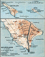
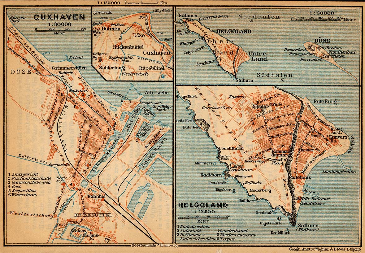
| 描述 | Map of Heligoland, Germany, 1910 |
| 日期 | |
| 來源 | http://www.lib.utexas.edu/maps/historical/baedeker_n_germany_1910/cuxhaven_helgoland_1910.jpg |
| 作者 | "Northern Germany as far as the Bavarian and Austrian Frontiers; Handbook for Travellers" by Karl Baedeker. Fifteenth Revised Edition. Leipzig, Karl Baedeker; New York, Charles Scribner's Sons 1910. |
| 授權許可 (重用此檔案) |
"Courtesy of the University of Texas Libraries, The University of Texas at Austin." http://www.lib.utexas.edu/maps/map_sites/hist_sites.html |
| 其他版本 |
Derivative works of this file: Map helgoland 1910 cropped.jpg cut from Image:Map cuxhaven helgoland 1910.jpg |
授權條款
[編輯]
|
本作品在其來源國以及其他著作權期限是作者逝世後70年或以下的國家與地區屬於公有領域。 | |
| 此作品無已知的著作權限制,亦不受所有相關和鄰接的權利限制。 | |
檔案歷史
點選日期/時間以檢視該時間的檔案版本。
| 日期/時間 | 縮圖 | 尺寸 | 使用者 | 備註 | |
|---|---|---|---|---|---|
| 目前 | 2006年4月23日 (日) 17:28 | | 603 × 769(344 KB) | 700 MB(留言 | 貢獻) | {{Information| |Description=Map of Heligoland, Germany, 1910 |Source=http://www.lib.utexas.edu/maps/historical/baedeker_n_germany_1910/cuxhaven_helgoland_1910.jpg |Date=1910 |Author="Northern Germany as far as the Bavarian and Austrian Frontiers; Handbo |
無法覆蓋此檔案。
檔案用途
下列2個頁面有用到此檔案:
全域檔案使用狀況
以下其他 wiki 使用了這個檔案:
- cs.wikipedia.org 的使用狀況
- en.wikipedia.org 的使用狀況
- en.wikiversity.org 的使用狀況
- eu.wikipedia.org 的使用狀況
- fy.wikipedia.org 的使用狀況
- gl.wikipedia.org 的使用狀況
- ja.wikipedia.org 的使用狀況
- mk.wikipedia.org 的使用狀況
- nl.wikipedia.org 的使用狀況
- nn.wikipedia.org 的使用狀況
- pl.wikipedia.org 的使用狀況
- uk.wikipedia.org 的使用狀況
- vi.wikipedia.org 的使用狀況
- yi.wikipedia.org 的使用狀況
- zh.wikipedia.org 的使用狀況