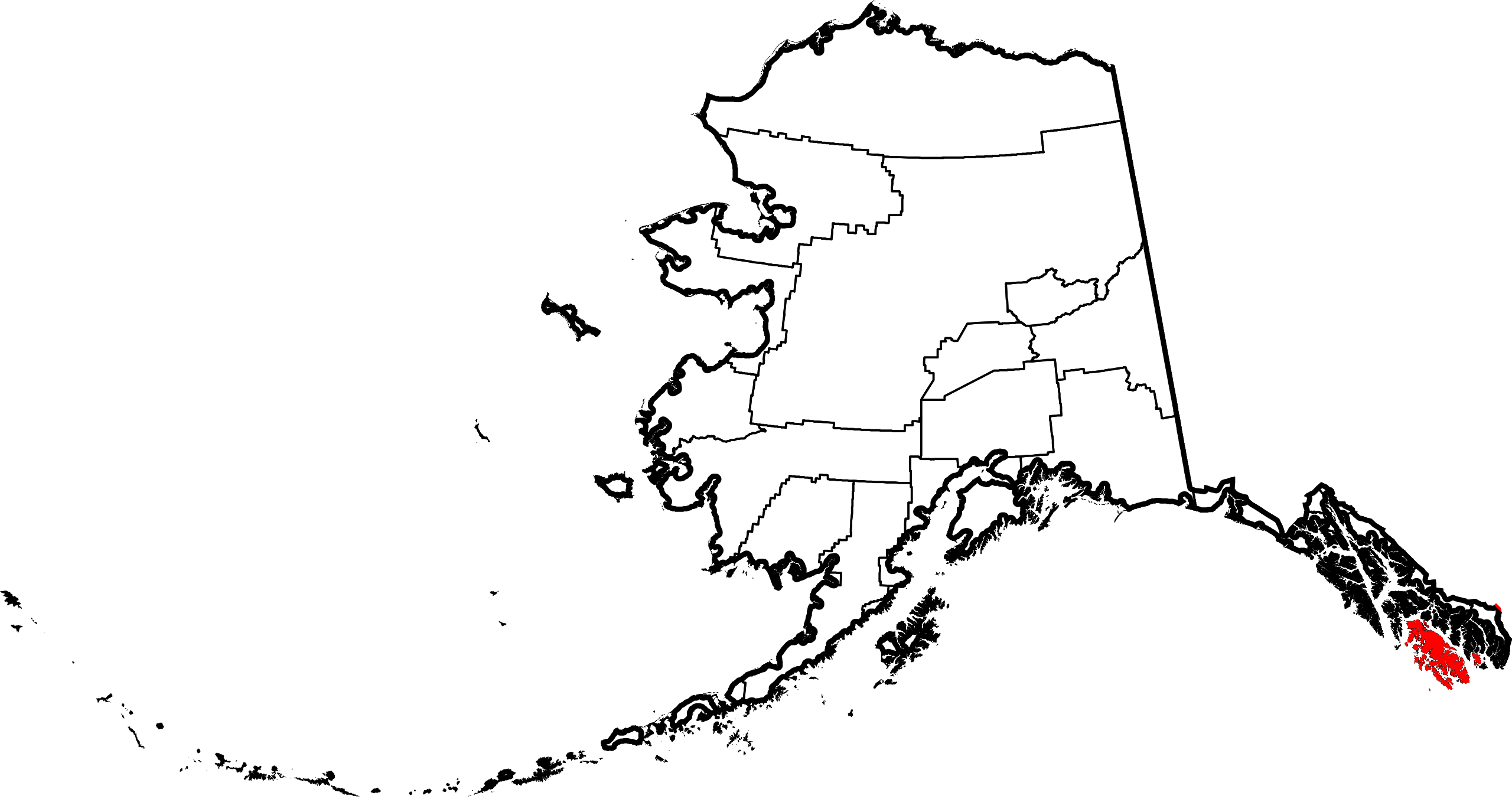
File:Map of Alaska highlighting Prince of Wales-Hyder Census Area.svg
跳至導覽
跳至搜尋

此 SVG 檔案的 PNG 預覽的大小:800 × 423 像素。 其他解析度:320 × 169 像素 | 640 × 338 像素 | 1,024 × 541 像素 | 1,280 × 677 像素 | 2,560 × 1,353 像素 | 1,470 × 777 像素。
原始檔案 (SVG 檔案,表面大小:1,470 × 777 像素,檔案大小:644 KB)
說明
說明
添加單行說明來描述出檔案所代表的內容

檔案歷史
點選日期/時間以檢視該時間的檔案版本。
| 日期/時間 | 縮圖 | 尺寸 | 使用者 | 備註 | |
|---|---|---|---|---|---|
| 目前 | 2024年6月25日 (二) 20:13 | | 1,470 × 777(644 KB) | Nux(留言 | 貢獻) | uniform colors with good contrast |
| 2009年2月7日 (六) 16:42 |  | 1,470 × 777(475 KB) | Niagara(留言 | 貢獻) | == Summary == {{Information |Description={{en|1=Map of Alaska highlighting the Prince of Wales-Hyder Census Area}} |Source=self made |Author=Dtbohrer |Date=February 7, 2009 |Pe |
無法覆蓋此檔案。
檔案用途
全域檔案使用狀況
以下其他 wiki 使用了這個檔案:
- ca.wikipedia.org 的使用狀況
- ce.wikipedia.org 的使用狀況
- de.wikipedia.org 的使用狀況
- en.wikipedia.org 的使用狀況
- List of boroughs and census areas in Alaska
- Prince of Wales–Hyder Census Area, Alaska
- Coffman Cove, Alaska
- Craig, Alaska
- Edna Bay, Alaska
- Hollis, Alaska
- Hydaburg, Alaska
- Hyder, Alaska
- Kasaan, Alaska
- Klawock, Alaska
- Metlakatla, Alaska
- Naukati Bay, Alaska
- Point Baker, Alaska
- Port Protection, Alaska
- Thorne Bay, Alaska
- Whale Pass, Alaska
- Kake, Alaska
- Port Alexander, Alaska
- Revillagigedo Channel
- Clarence Strait
- Annette Island
- Gravina Islands
- Sumner Strait
- Waterfall, Alaska
- Portland Canal
- Salmon River (Portland Canal)
- Unorganized Borough, Alaska
- Wikipedia:WikiProject Alaska
- Forrester Island Wilderness
- Hazy Islands Wilderness
- Kosciusko Island
- Warren Island (Alaska)
- Suemez Island
- Long Island (Alaska)
- Template:Prince of Wales–Hyder Census Area, Alaska
- Template:Unorganized Borough, Alaska
- Bucareli Bay
- Heceta Island
- Sukkwan Island
- Baker Island (Alaska)
- User:Nyttend/County templates/AK
- Template:PrinceofWalesHyderAK-geo-stub
- National Register of Historic Places listings in Prince of Wales–Hyder Census Area, Alaska
- Seward Mountains (Alaska)
- Lincoln Mountains
- Karta River Wilderness
- Grindall Island
檢視此檔案的更多全域使用狀況。