File:Map of Alaska highlighting Prince of Wales-Outer Ketchikan Census Area.svg
跳转到导航
跳转到搜索

此SVG文件的PNG预览的大小:800 × 423像素。 其他分辨率:320 × 169像素 | 640 × 338像素 | 1,024 × 541像素 | 1,280 × 677像素 | 2,560 × 1,353像素 | 1,470 × 777像素。
原始文件 (SVG文件,尺寸为1,470 × 777像素,文件大小:338 KB)
说明
说明
添加一行文字以描述该文件所表现的内容
摘要[编辑]
| 描述 |
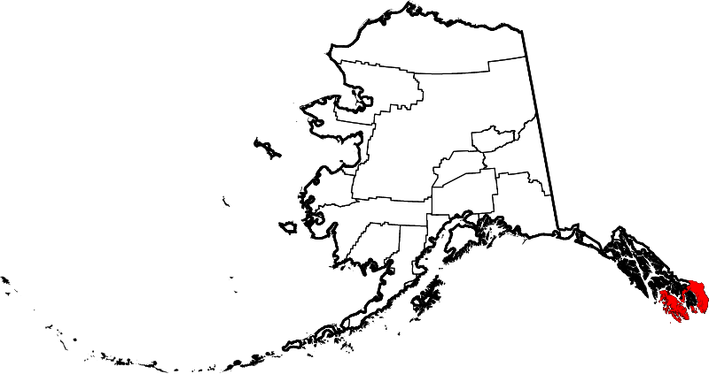
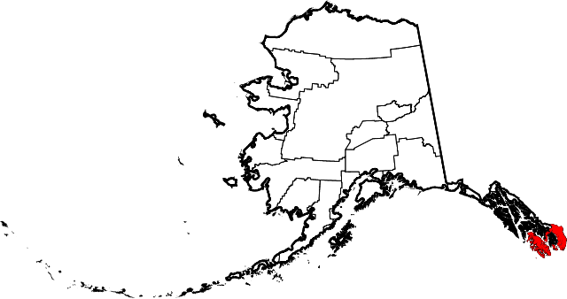
English: This is a locator map showing the former Prince of Wales-Outer Ketchikan Census Area in Alaska. In 2008, Ketchikan Gateway Borough annexed Outer Ketchikan, and the census area is now named Prince of Wales-Hyder Census Area. For a map showing the new boundaries, see Map of Alaska highlighting Prince of Wales-Hyder Census Area.svg |
| 日期 | |
| 来源 |
自己的作品: English: The maps use data from nationalatlas.gov, specifically countyp020.tar.gz on the Raw Data Download page. The maps also use state outline data from statesp020.tar.gz. The Florida maps use hydrogm020.tar.gz to display Lake Okeechobee. |
| 作者 | David Benbennick |
| SVG开发 |
许可协议[编辑]
| 我,本作品著作权人,释出本作品至公有领域。这适用于全世界。 在一些国家这可能不合法;如果是这样的话,那么: 我无条件地授予任何人以任何目的使用本作品的权利,除非这些条件是法律规定所必需的。 |
文件历史
点击某个日期/时间查看对应时刻的文件。
| 日期/时间 | 缩略图 | 大小 | 用户 | 备注 | |
|---|---|---|---|---|---|
| 当前 | 2006年3月5日 (日) 19:28 | | 1,470 × 777(338 KB) | David Benbennick(留言 | 贡献) | {{subst:User:Dbenbenn/clm|county=Prince of Wales-Outer Ketchikan Census Area|state=Alaska|type=borough and census area}} |
您不可以覆盖此文件。
文件用途
全域文件用途
以下其他wiki使用此文件:
- bpy.wikipedia.org上的用途
- de.wikipedia.org上的用途
- en.wikipedia.org上的用途
- es.wikipedia.org上的用途
- fr.wikipedia.org上的用途
- gl.wikipedia.org上的用途
- id.wikipedia.org上的用途
- nds.wikipedia.org上的用途
- nl.wikipedia.org上的用途
- no.wikipedia.org上的用途
- tr.wikipedia.org上的用途
- www.wikidata.org上的用途
- zh.wikipedia.org上的用途