File:Map of Alpine Glaciations.png
Naviqasiyaya keç
Axtarışa keç

Sınaq göstərişi ölçüsü: 800 × 512 piksel. Digər ölçülər: 320 × 205 piksel | 640 × 410 piksel | 1.026 × 657 piksel.
Faylın orijinalı (1.026 × 657 piksel, fayl həcmi: 1,43 MB, MIME növü: image/png)
Captions
Captions
Add a one-line explanation of what this file represents
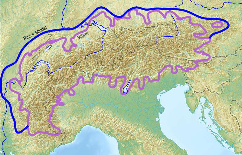
Approximate extent of alpine glaciations

|
This geology image could be re-created using vector graphics as an SVG file. This has several advantages; see Commons:Media for cleanup for more information. If an SVG form of this image is available, please upload it and afterwards replace this template with
{{vector version available|new image name}}.
It is recommended to name the SVG file “Map of Alpine Glaciations.svg”—then the template Vector version available (or Vva) does not need the new image name parameter. |
| İzah |
Deutsch: Ungefähre Ausdehnung der Vereisungen in den Alpen English: Approximate extent of alpine glaciations |
| Tarix | (UTC) |
| Mənbə |
|
| Müəllif |
|
| Bu təsvirin redaktəsi, orijinala əsaslanaraq rəqəmsal qaydadadır. Dəyişiklik: Limits of alpine ice sheets, cropped black border. İlkin təsvir buradadır: Alps location map.png. Redaktə etdi Jo Weber.
|
I, the copyright holder of this work, hereby publish it under the following licenses:
| Bu fayl Creative Commons Attribution-Share Alike 3.0 Unported lisenziyası altında yayımlanır. | ||
| ||
| This licensing tag was added to this file as part of the GFDL licensing update. |

|
Bu sənədi GNU Azad Sənədləşdirmə Lisenziyası, Versiya 1.2 və ya Azad Proqram Fondu tərəfindən nəşr olunan hər hansı sonrakı versiya şərtlərinə əsasən dəyişməz bölmələr, ön qapaq mətnləri və arxa qapaq mətnləri olmadan köçürmək, yayımlamaq və / və ya dəyişdirmək üçün icazə verilir; Lisenziyanın bir nüsxəsi GNU Azad Sənədləşdirmə Lisenziyası adlı hissəyə daxil edilmişdir. |
İstədiyiniz lisenziyanı seçə bilərsiniz.
The map has been created with the Generic Mapping Tools: https://www.generic-mapping-tools.org/ using one or more of these public-domain datasets for the relief:
|
|
|
Bu sənədi GNU Azad Sənədləşdirmə Lisenziyası, Versiya 1.2 və ya Azad Proqram Fondu tərəfindən nəşr olunan hər hansı sonrakı versiya şərtlərinə əsasən dəyişməz bölmələr, ön qapaq mətnləri və arxa qapaq mətnləri olmadan köçürmək, yayımlamaq və / və ya dəyişdirmək üçün icazə verilir; Lisenziyanın bir nüsxəsi GNU Azad Sənədləşdirmə Lisenziyası adlı hissəyə daxil edilmişdir. |
Orijinal yükləmə gündəliyi
[redaktə]
This image is a derivative work of the following images:
- File:Alps_location_map.png licensed with Cc-by-sa-3.0-migrated, GFDL-GMT
- 2009-02-20T12:58:57Z Lencer 2000x1381 (4957657 Bytes) {{Information |Description= {{de|Positionskarte der [[:de:Alpen|Alpen]]}} Quadratische Plattkarte. Geographische Begrenzung der Karte: * N: 48.5 ° N * S: 42.75 ° N * W: 4.5 ° O * O: 17 ° O {{en|Location map of the
Uploaded with derivativeFX
Faylın tarixçəsi
Faylın əvvəlki versiyasını görmək üçün gün/tarix bölməsindəki tarixlərə klikləyin.
| Tarix/Vaxt | Miniatür | Ölçülər | İstifadəçi | Şərh | |
|---|---|---|---|---|---|
| hal-hazırkı | 20:00, 10 fevral 2010 | | 1.026 × 657 (1,43 MB) | Jo Weber (müzakirə | töhfələr) | {{Information |Description={{de|Ausdehnung der Vereisungen Alpen}} {{en|Extent of alpine glciations}} |Source=*File:Alps_location_map.png and following sources: * Rudolf Hohl (Hrsg.): Die Entwicklungsgeschichte der Erde. 6. Auflage. W |
Siz bu faylı yenidən yükləyə bilməzsiniz.
Faylın istifadəsi
Aşağıdakı səhifə bu faylı istifadə edir:
Faylın qlobal istifadəsi
Bu fayl aşağıdakı vikilərdə istifadə olunur:
- ar.wikipedia.org layihəsində istifadəsi
- az.wikipedia.org layihəsində istifadəsi
- be.wikipedia.org layihəsində istifadəsi
- ca.wikipedia.org layihəsində istifadəsi
- de.wikipedia.org layihəsində istifadəsi
- de.wiktionary.org layihəsində istifadəsi
- en.wikipedia.org layihəsində istifadəsi
- Last Glacial Period
- Last Interglacial
- Würm glaciation
- Mindel glaciation
- Riss glaciation
- Late Pleistocene
- Holstein interglacial
- Gunz (geology)
- Template:Alpine glaciations
- Danube (geology)
- Haslach glaciation
- Biber (geology)
- Biber-Danube interglacial
- Danube-Gunz interglacial
- Gunz-Haslach interglacial
- Haslach-Mindel interglacial
- Climate of France
- es.wikipedia.org layihəsində istifadəsi
- es.wikibooks.org layihəsində istifadəsi
- fa.wikipedia.org layihəsində istifadəsi
- fi.wikipedia.org layihəsində istifadəsi
- fr.wikipedia.org layihəsində istifadəsi
- fy.wikipedia.org layihəsində istifadəsi
- it.wikipedia.org layihəsində istifadəsi
- it.wikibooks.org layihəsində istifadəsi
Bu faylın qlobal istifadəsinə baxın.
Kateqoriyalar:
- Geological maps of the Alps
- Ice age maps
- Geological maps of Bavaria
- Geological maps of Austria
- Geological maps of Switzerland
- Geological maps of France
- Geological maps of Italy
- Geological maps of Baden-Württemberg
- Maps of glaciers
- Alpine glaciations
- Pleistocene glaciations in Europe
- Pleistocene glaciations in Baden-Württemberg
- Pleistocene glaciations in Austria
- Pleistocene glaciations in Bavaria
- Pleistocene glaciations in Switzerland
- Pleistocene glaciations in France
- Pleistocene glaciations in Italy
- Pleistocene glaciations in the Alps