File:Map of Arabia 600 AD.svg
ナビゲーションに移動
検索に移動

この SVG ファイルのこの PNG プレビューのサイズ: 735 × 600 ピクセル. その他の解像度: 294 × 240 ピクセル | 588 × 480 ピクセル | 941 × 768 ピクセル | 1,255 × 1,024 ピクセル | 2,509 × 2,048 ピクセル | 860 × 702 ピクセル。
元のファイル (SVG ファイル、860 × 702 ピクセル、ファイルサイズ: 1,004キロバイト)
キャプション
キャプション
このファイルの内容を1行で記述してください
| 解説 |
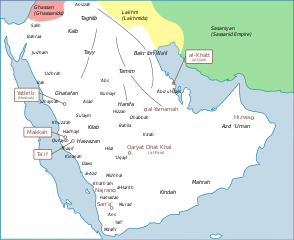
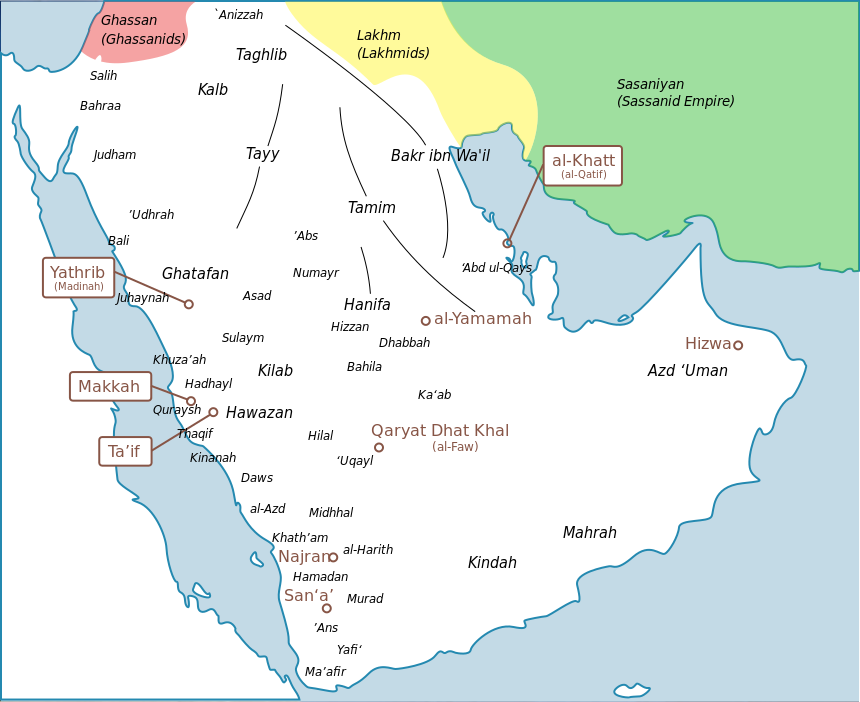
English: a map of arabia with tribes and |
| 日付 | |
| 原典 | I created this work entirely by myself, with info from [see below] |
| 作者 | murraytheb موري (talk) |
| その他のバージョン |
adapted from File:Tribes_english.png  |
| この著作物の著作権者である私は、この著作物における権利を放棄しパブリックドメインとします。これは全世界で適用されます。 一部の国では、これが法的に可能ではない場合があります。その場合は、次のように宣言します。 私は、あらゆる人に対して、法により必要とされている条件を除き、如何なる条件も課すことなく、あらゆる目的のためにこの著作物を使用する権利を与えます。 |
元のアップロードログ[編集]
元のファイルページはこちら。以下の利用者は全てen.wikipediaに属します。
- 2009-05-25 20:38 Murraytheb 860×702× (966553 bytes) {{Information |Description = a map of arabia with tribes and |Source = I created this work entirely by myself, with info from [see below] |Date = 25 may 2009 |Author = ~~~ |other_versions = adapted from [[File:Tribe
ファイルの履歴
過去の版のファイルを表示するには、その版の日時をクリックしてください。
| 日付と時刻 | サムネイル | 寸法 | 利用者 | コメント | |
|---|---|---|---|---|---|
| 現在の版 | 2024年3月26日 (火) 14:57 | | 860 × 702 (1,004キロバイト) | Haziq Faruqi (トーク | 投稿記録) | File uploaded using svgtranslate tool (https://svgtranslate.toolforge.org/). Added translation for ms. |
| 2017年11月26日 (日) 18:51 |  | 860 × 702 (967キロバイト) | Maproom (トーク | 投稿記録) | Swapped positions of Ma'afir and 'Ans, as requested by User:Tiwahi at https://commons.wikimedia.org/wiki/User_talk:Maproom#Arabia_600_AD_Map_minor_detail | |
| 2016年7月16日 (土) 16:32 |  | 860 × 702 (967キロバイト) | Maproom (トーク | 投稿記録) | Make Persian green not blue to distinguish it from the sea | |
| 2016年7月16日 (土) 16:30 |  | 860 × 702 (967キロバイト) | Maproom (トーク | 投稿記録) | Persia green not blue, to distinguish it from the sea | |
| 2016年7月16日 (土) 16:30 |  | 860 × 702 (967キロバイト) | Maproom (トーク | 投稿記録) | Persia green not blue, to distinguish it from the sea | |
| 2012年10月21日 (日) 13:28 |  | 860 × 702 (967キロバイト) | ChrisCrea (トーク | 投稿記録) | Little updates in the north (sorry cache problems) | |
| 2012年10月21日 (日) 13:26 |  | 860 × 702 (965キロバイト) | ChrisCrea (トーク | 投稿記録) | Reverted to version as of 13:10, 21 October 2012 | |
| 2012年10月21日 (日) 13:24 |  | 860 × 702 (965キロバイト) | ChrisCrea (トーク | 投稿記録) | Little updates in the north | |
| 2012年10月21日 (日) 13:10 |  | 860 × 702 (965キロバイト) | ChrisCrea (トーク | 投稿記録) | Font/text optimization, some new tribes | |
| 2010年4月30日 (金) 00:27 |  | 860 × 702 (944キロバイト) | CambridgeBayWeather (トーク | 投稿記録) | {{Information |Description={{en|a map of arabia with tribes and}} |Source=Transferred from [http://en.wikipedia.org en.wikipedia]<br/> (Original text : ''I created this work entirely by myself, with info from from [see below]'') |Date=25 may 2009<br/> ({{ |
このファイルは上書きできません。
ファイルの使用状況
以下の 3 ページがこのファイルを使用しています:
グローバルなファイル使用状況
以下に挙げる他のウィキがこの画像を使っています:
- azb.wikipedia.org での使用状況
- bn.wikipedia.org での使用状況
- ca.wikipedia.org での使用状況
- de.wikipedia.org での使用状況
- de.wikiversity.org での使用状況
- en.wikipedia.org での使用状況
- eo.wikipedia.org での使用状況
- es.wikipedia.org での使用状況
- fa.wikipedia.org での使用状況
- fr.wikipedia.org での使用状況
- fr.wikibooks.org での使用状況
- he.wikipedia.org での使用状況
- hi.wikipedia.org での使用状況
- id.wikipedia.org での使用状況
- it.wikipedia.org での使用状況
このファイルのグローバル使用状況を表示する。
メタデータ
カテゴリ:
- Maps of pre-Islamic Arabia
- Thamud
- Banu Bakr
- Banu Kalb
- Banu Tamim
- Banu Taghlib
- Banu Ghatafan
- Banu Hawazin
- Banu Tayy
- Banu Kinda
- Maps of the Ghassanid Kingdom
- Maps of the Lakhmid Kingdom
- Banu Judham
- Banu Khuza'ah
- Banu Udhrah
- Banu Juhaynah
- Banu Thaqif
- Banu Hadhayl
- Banu Kinanah
- Banu Sulaym
- Banu Hilal
- Banu Abbs
- Banu Daws
- Banu Uqayl
- Banu Harith
- Maps of Qatif
- English-language SVG maps showing history