File:Map of Arabia 600 AD.svg
跳至導覽
跳至搜尋

此 SVG 檔案的 PNG 預覽的大小:735 × 600 像素。 其他解析度:294 × 240 像素 | 588 × 480 像素 | 941 × 768 像素 | 1,255 × 1,024 像素 | 2,509 × 2,048 像素 | 860 × 702 像素。
原始檔案 (SVG 檔案,表面大小:860 × 702 像素,檔案大小:1,004 KB)
說明
說明
添加單行說明來描述出檔案所代表的內容
| 描述 |
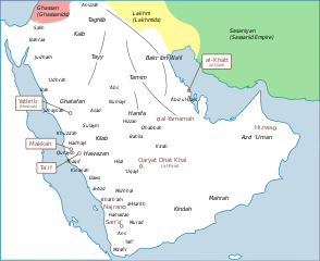
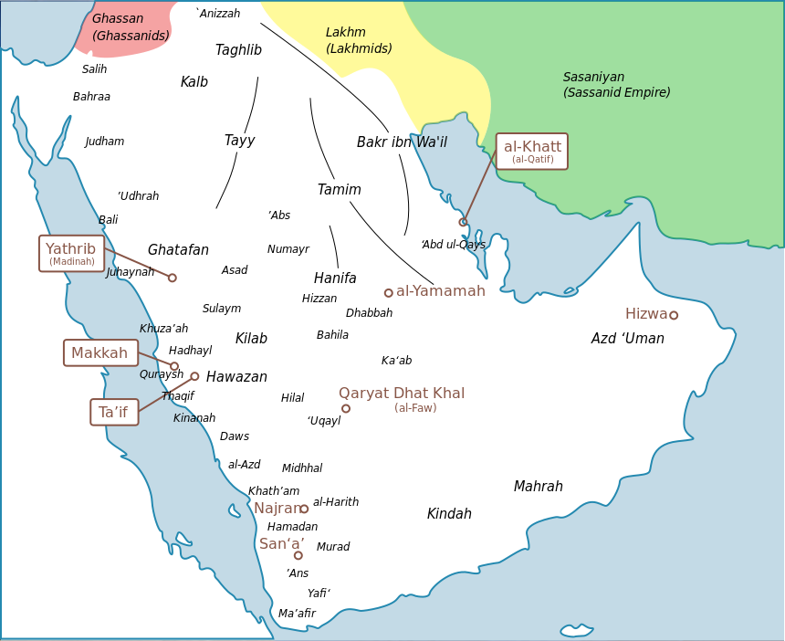
English: a map of arabia with tribes and |
| 日期 | |
| 來源 | I created this work entirely by myself, with info from [see below] |
| 作者 | murraytheb موري (talk) |
| 其他版本 |
adapted from File:Tribes_english.png  |
| 我,此作品的版權所有人,釋出此作品至公共領域。此授權條款在全世界均適用。 這可能在某些國家不合法,如果是的話: 我授予任何人有權利使用此作品於任何用途,除受法律約束外,不受任何限制。 |
原始上傳日誌
[編輯]
The original description page was here. All following user names refer to en.wikipedia.
- 2009-05-25 20:38 Murraytheb 860×702× (966553 bytes) {{Information |Description = a map of arabia with tribes and |Source = I created this work entirely by myself, with info from [see below] |Date = 25 may 2009 |Author = ~~~ |other_versions = adapted from [[File:Tribe
檔案歷史
點選日期/時間以檢視該時間的檔案版本。
| 日期/時間 | 縮圖 | 尺寸 | 使用者 | 備註 | |
|---|---|---|---|---|---|
| 目前 | 2024年3月26日 (二) 14:57 | | 860 × 702(1,004 KB) | Haziq Faruqi(留言 | 貢獻) | File uploaded using svgtranslate tool (https://svgtranslate.toolforge.org/). Added translation for ms. |
| 2017年11月26日 (日) 18:51 |  | 860 × 702(967 KB) | Maproom(留言 | 貢獻) | Swapped positions of Ma'afir and 'Ans, as requested by User:Tiwahi at https://commons.wikimedia.org/wiki/User_talk:Maproom#Arabia_600_AD_Map_minor_detail | |
| 2016年7月16日 (六) 16:32 |  | 860 × 702(967 KB) | Maproom(留言 | 貢獻) | Make Persian green not blue to distinguish it from the sea | |
| 2016年7月16日 (六) 16:30 |  | 860 × 702(967 KB) | Maproom(留言 | 貢獻) | Persia green not blue, to distinguish it from the sea | |
| 2016年7月16日 (六) 16:30 |  | 860 × 702(967 KB) | Maproom(留言 | 貢獻) | Persia green not blue, to distinguish it from the sea | |
| 2012年10月21日 (日) 13:28 |  | 860 × 702(967 KB) | ChrisCrea(留言 | 貢獻) | Little updates in the north (sorry cache problems) | |
| 2012年10月21日 (日) 13:26 |  | 860 × 702(965 KB) | ChrisCrea(留言 | 貢獻) | Reverted to version as of 13:10, 21 October 2012 | |
| 2012年10月21日 (日) 13:24 |  | 860 × 702(965 KB) | ChrisCrea(留言 | 貢獻) | Little updates in the north | |
| 2012年10月21日 (日) 13:10 |  | 860 × 702(965 KB) | ChrisCrea(留言 | 貢獻) | Font/text optimization, some new tribes | |
| 2010年4月30日 (五) 00:27 |  | 860 × 702(944 KB) | CambridgeBayWeather(留言 | 貢獻) | {{Information |Description={{en|a map of arabia with tribes and}} |Source=Transferred from [http://en.wikipedia.org en.wikipedia]<br/> (Original text : ''I created this work entirely by myself, with info from from [see below]'') |Date=25 may 2009<br/> ({{ |
無法覆蓋此檔案。
檔案用途
下列3個頁面有用到此檔案:
全域檔案使用狀況
以下其他 wiki 使用了這個檔案:
- azb.wikipedia.org 的使用狀況
- bn.wikipedia.org 的使用狀況
- ca.wikipedia.org 的使用狀況
- ckb.wikipedia.org 的使用狀況
- de.wikipedia.org 的使用狀況
- de.wikiversity.org 的使用狀況
- en.wikipedia.org 的使用狀況
- eo.wikipedia.org 的使用狀況
- es.wikipedia.org 的使用狀況
- fa.wikipedia.org 的使用狀況
- fr.wikipedia.org 的使用狀況
- fr.wikibooks.org 的使用狀況
- he.wikipedia.org 的使用狀況
- hi.wikipedia.org 的使用狀況
- id.wikipedia.org 的使用狀況
- it.wikipedia.org 的使用狀況
檢視此檔案的更多全域使用狀況。
詮釋資料
分類:
- Maps of pre-Islamic Arabia
- Thamud
- Banu Bakr
- Banu Kalb
- Banu Tamim
- Banu Taghlib
- Banu Ghatafan
- Banu Hawazin
- Banu Tayy
- Banu Kinda
- Maps of the Ghassanid Kingdom
- Maps of the Lakhmid Kingdom
- Banu Judham
- Banu Khuza'ah
- Banu Udhrah
- Banu Juhaynah
- Banu Thaqif
- Banu Hadhayl
- Banu Kinanah
- Banu Sulaym
- Banu Hilal
- Banu Abbs
- Banu Daws
- Banu Uqayl
- Banu Harith
- Maps of Qatif
- English-language SVG maps showing history