File:Map of Florida highlighting St. Johns County.svg
Aller à la navigation
Aller à la recherche

Taille de cet aperçu PNG pour ce fichier SVG : 601 × 599 pixels. Autres résolutions : 241 × 240 pixels | 481 × 480 pixels | 770 × 768 pixels | 1 027 × 1 024 pixels | 2 054 × 2 048 pixels | 7 342 × 7 321 pixels.
Fichier d’origine (Fichier SVG, nominalement de 7 342 × 7 321 pixels, taille : 310 kio)
Légendes
Légendes
Ajoutez en une ligne la description de ce que représente ce fichier
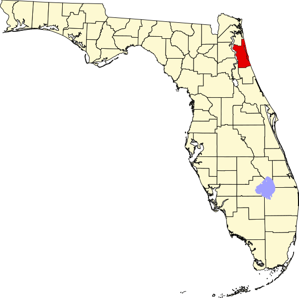
This is a locator map showing Saint Johns County in Florida.
David Benbennick made this map. For more information, see Commons:United States county locator maps.
| Moi, propriétaire des droits d’auteur sur cette œuvre, la place dans le domaine public. Ceci s'applique dans le monde entier. Dans certains pays, ceci peut ne pas être possible ; dans ce cas : J’accorde à toute personne le droit d’utiliser cette œuvre dans n’importe quel but, sans aucune condition, sauf celles requises par la loi. |
Historique du fichier
Cliquer sur une date et heure pour voir le fichier tel qu'il était à ce moment-là.
| Date et heure | Vignette | Dimensions | Utilisateur | Commentaire | |
|---|---|---|---|---|---|
| actuel | 14 février 2006 à 05:43 | | 7 342 × 7 321 (310 kio) | David Benbennick (d | contributions) | New version with Lake Okeechobee |
| 12 février 2006 à 10:51 |  | 7 342 × 7 321 (307 kio) | David Benbennick (d | contributions) | {{subst:User:Dbenbenn/clm|county=Saint Johns County|state=Florida}} |
Vous ne pouvez pas remplacer ce fichier.
Utilisations locales du fichier
Les 11 pages suivantes utilisent ce fichier :
- File:Map of Florida highlighting Saint Johns County.svg (redirection de fichier)
- File:Map of Florida highlighting St Johns County.svg (redirection de fichier)
- Category:Births in St. Johns County, Florida
- Category:Deaths in St. Johns County, Florida
- Category:Maps of St. Johns County, Florida
- Category:Matanzas State Forest
- Category:National Register of Historic Places in St. Johns County, Florida
- Category:People of St. Johns County, Florida
- Category:Populated places in St. Johns County, Florida
- Category:St. Johns County, Florida
- Category:Views of St. Johns County, Florida
Utilisations du fichier sur d’autres wikis
Les autres wikis suivants utilisent ce fichier :
- Utilisation sur ar.wikipedia.org
- Utilisation sur arz.wikipedia.org
- Utilisation sur bg.wikipedia.org
- Utilisation sur bpy.wikipedia.org
- Utilisation sur cdo.wikipedia.org
- Utilisation sur ceb.wikipedia.org
- Utilisation sur ce.wikipedia.org
- Utilisation sur cy.wikipedia.org
- Utilisation sur de.wikipedia.org
- St. Johns County
- St. Augustine (Florida)
- Marineland (Florida)
- Vorlage:Navigationsleiste Orte im St. Johns County
- Hastings (Florida)
- St. Augustine Beach
- Butler Beach
- Crescent Beach (Florida)
- Flagler Estates
- Fruit Cove
- Nocatee
- Palm Valley (Florida)
- Sawgrass
- St. Augustine Shores
- St. Augustine South
- Vilano Beach
- World Golf Village
- Utilisation sur en.wikipedia.org
- List of counties in Florida
- St. Johns County, Florida
- Marineland, Florida
- Butler Beach, Florida
- Crescent Beach, St. Johns County, Florida
- Fruit Cove, Florida
- Hastings, Florida
- Palm Valley, Florida
- Sawgrass, Florida
- St. Augustine, Florida
- St. Augustine Shores, Florida
- Vilano Beach, Florida
- St. Augustine Beach, Florida
- St. Augustine South, Florida
- Ponte Vedra Beach, Florida
- Template:St. Johns County, Florida
- Switzerland, Florida
- Julington Creek Plantation, Florida
- Elkton, Florida
- Armstrong, Florida
- Spuds, Florida
- Vermont Heights, Florida
- St. Johns, Florida
Voir davantage sur l’utilisation globale de ce fichier.