File:Map of Indiana highlighting Clinton County.svg
Μετάβαση στην πλοήγηση
Πήδηση στην αναζήτηση

Το μέγεθος αυτής της PNG προεπισκόπησης αυτού του SVG το αρχείο: 391 × 599 εικονοστοιχεία. Άλλες αναλύσεις: 156 × 240 εικονοστοιχεία | 313 × 480 εικονοστοιχεία | 501 × 768 εικονοστοιχεία | 668 × 1.024 εικονοστοιχεία | 1.337 × 2.048 εικονοστοιχεία | 2.887 × 4.423 εικονοστοιχεία.
Πρωτότυπο αρχείο (Αρχείο SVG, ονομαστικό μέγεθος 2.887 × 4.423 εικονοστοιχεία, μέγεθος αρχείου: 56 KB)
Λεζάντες
Λεζάντες
Δεν ορίστηκε λεζάντα
Σύνοψη[επεξεργασία]
| Περιγραφή |
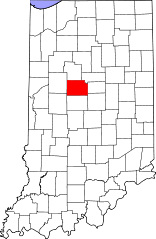
English: This is a locator map showing Clinton County in Indiana. For more information, see Commons:United States county locator maps. |
| Ημερομηνία | |
| Πηγή |
Έργο αυτού που το ανεβάζει: English: The maps use data from nationalatlas.gov, specifically countyp020.tar.gz on the Raw Data Download page. The maps also use state outline data from statesp020.tar.gz. The Florida maps use hydrogm020.tar.gz to display Lake Okeechobee. |
| Δημιουργός | David Benbennick |
Αδειοδότηση[επεξεργασία]
| Εγώ, ο κάτοχος των πνευματικών δικαιωμάτων αυτού του έργου, δημοσιεύω αυτό το έργο ως κοινό κτήμα. Αυτό ισχύει σε παγκόσμια κλίμακα. Σε ορισμένες χώρες αυτό μπορεί να μην είναι νομικά εφικτό. Αν ναι: Παραχωρώ σε οποιονδήποτε το δικαίωμα να χρησιμοποιήσει αυτό το έργο "για οποιονδήποτε σκοπό", χωρίς κανέναν όρο, εκτός και αν τέτοιοι όροι τίθενται από την νομοθεσία |
Ιστορικό αρχείου
Πατήστε σε μια ημερομηνία/ώρα για να δείτε το αρχείο όπως εμφανιζόταν εκείνη την χρονική στιγμή.
| Ημερομηνία/Ώρα | Μικρογραφία | Διαστάσεις | Χρήστης | Σχόλιο | |
|---|---|---|---|---|---|
| τρέχον | 12:09, 12 Φεβρουαρίου 2006 | | 2.887 × 4.423 (56 KB) | David Benbennick (συζήτηση | Συνεισφορά) | {{subst:User:Dbenbenn/clm|county=Clinton County|state=Indiana}} |
Δεν μπορείτε να αντικαταστήσετε αυτό το αρχείο.
Χρήση αρχείου
Οι ακόλουθες 11 σελίδες χρησιμοποιούν προς αυτό το αρχείο:
- Category:Births in Clinton County, Indiana
- Category:Clinton County, Indiana
- Category:Clinton County, Indiana Image by Chris Light
- Category:Geography of Clinton County, Indiana
- Category:Historic districts in Clinton County, Indiana
- Category:Maps of Clinton County, Indiana
- Category:National Register of Historic Places in Clinton County, Indiana
- Category:People of Clinton County, Indiana
- Category:Populated places in Clinton County, Indiana
- Category:Towns in Clinton County, Indiana
- Category:Visitor attractions in Clinton County, Indiana
Καθολική χρήση αρχείου
Τα ακόλουθα άλλα wiki χρησιμοποιούν αυτό το αρχείο:
- Χρήση σε ar.wikipedia.org
- Χρήση σε bg.wikipedia.org
- Χρήση σε bpy.wikipedia.org
- Χρήση σε cdo.wikipedia.org
- Χρήση σε ceb.wikipedia.org
- Χρήση σε ce.wikipedia.org
- Χρήση σε cy.wikipedia.org
- Χρήση σε de.wikipedia.org
- Χρήση σε el.wikipedia.org
- Χρήση σε en.wikipedia.org
- Clinton County, Indiana
- List of counties in Indiana
- Colfax, Indiana
- Frankfort, Indiana
- Kirklin, Indiana
- Michigantown, Indiana
- Mulberry, Indiana
- Rossville, Indiana
- Manson, Indiana
- Center Township, Clinton County, Indiana
- Forest Township, Clinton County, Indiana
- Jackson Township, Clinton County, Indiana
- Johnson Township, Clinton County, Indiana
- Kirklin Township, Clinton County, Indiana
- Madison Township, Clinton County, Indiana
- Michigan Township, Clinton County, Indiana
- Owen Township, Clinton County, Indiana
- Perry Township, Clinton County, Indiana
- Ross Township, Clinton County, Indiana
- Sugar Creek Township, Clinton County, Indiana
- Union Township, Clinton County, Indiana
- Warren Township, Clinton County, Indiana
- Washington Township, Clinton County, Indiana
- Template:Clinton County, Indiana
- Antioch, Clinton County, Indiana
- Template:ClintonCountyIN-geo-stub
- Avery, Indiana
- Beard, Indiana
- Boyleston, Indiana
- Cambria, Indiana
- Cyclone, Indiana
- Edna Mills, Indiana
- Fickle, Indiana
- Forest, Indiana
- Geetingsville, Indiana
Δείτε περισσότερη καθολική χρήση αυτού του αρχείου.