File:Map of Indiana highlighting Crawford County.svg
跳至導覽
跳至搜尋

此 SVG 檔案的 PNG 預覽的大小:391 × 599 像素。 其他解析度:156 × 240 像素 | 313 × 480 像素 | 501 × 768 像素 | 668 × 1,024 像素 | 1,337 × 2,048 像素 | 722 × 1,106 像素。
原始檔案 (SVG 檔案,表面大小:722 × 1,106 像素,檔案大小:42 KB)
說明
說明
添加單行說明來描述出檔案所代表的內容
摘要
[編輯]
| 描述 |
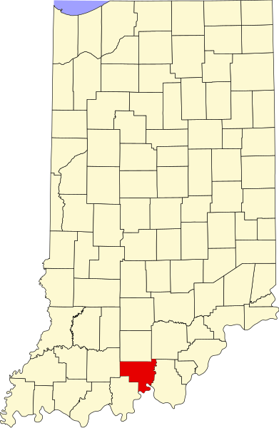
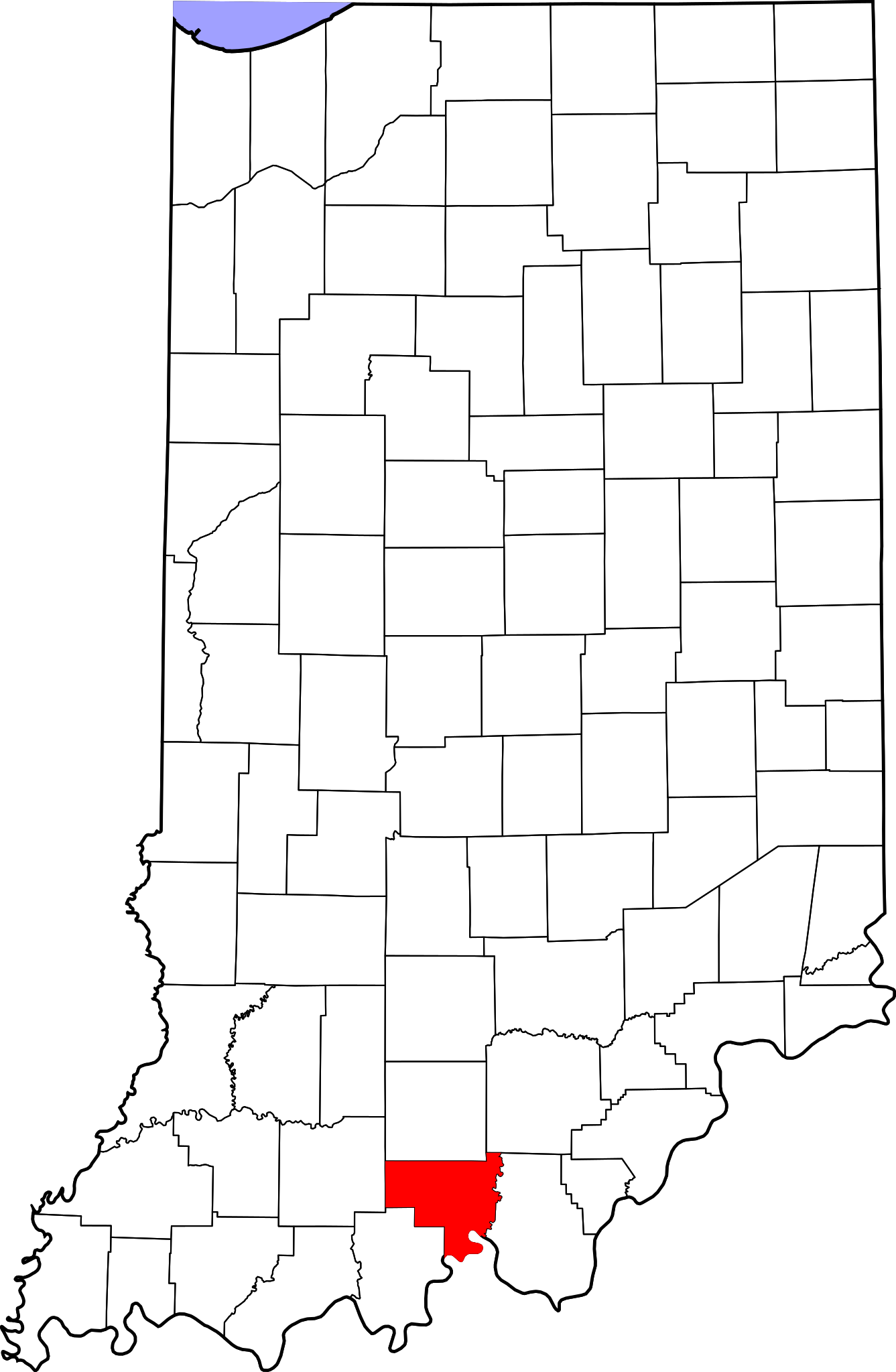
English: This is a locator map showing Crawford County in Indiana. For more information, see Commons:United States county locator maps. |
| 日期 | |
| 來源 |
自己的作品: English: The maps use data from nationalatlas.gov, specifically countyp020.tar.gz on the Raw Data Download page. The maps also use state outline data from statesp020.tar.gz. The Florida maps use hydrogm020.tar.gz to display Lake Okeechobee. |
| 作者 | David Benbennick |
授權條款
[編輯]
| 我,此作品的版權所有人,釋出此作品至公共領域。此授權條款在全世界均適用。 這可能在某些國家不合法,如果是的話: 我授予任何人有權利使用此作品於任何用途,除受法律約束外,不受任何限制。 |
檔案歷史
點選日期/時間以檢視該時間的檔案版本。
| 日期/時間 | 縮圖 | 尺寸 | 用戶 | 備註 | |
|---|---|---|---|---|---|
| 目前 | 2024年6月25日 (二) 14:34 | | 722 × 1,106(42 KB) | Nux(對話 | 貢獻) | uniform colors with good contrast |
| 2024年6月19日 (三) 20:38 |  | 722 × 1,106(42 KB) | Nux(對話 | 貢獻) | fix rendering (remove clipping) | |
| 2006年2月12日 (日) 12:09 |  | 2,887 × 4,423(56 KB) | David Benbennick(對話 | 貢獻) | {{subst:User:Dbenbenn/clm|county=Crawford County|state=Indiana}} |
無法覆蓋此檔案。
檔案用途
下列9個頁面有用到此檔案:
- Category:Births in Crawford County, Indiana
- Category:Crawford County, Indiana
- Category:Geography of Crawford County, Indiana
- Category:Maps of Crawford County, Indiana
- Category:National Register of Historic Places in Crawford County, Indiana
- Category:People of Crawford County, Indiana
- Category:Populated places in Crawford County, Indiana
- Category:Towns in Crawford County, Indiana
- Category:Visitor attractions in Crawford County, Indiana
全域檔案使用狀況
以下其他 wiki 使用了這個檔案:
- ar.wikipedia.org 的使用狀況
- bg.wikipedia.org 的使用狀況
- bpy.wikipedia.org 的使用狀況
- cdo.wikipedia.org 的使用狀況
- ceb.wikipedia.org 的使用狀況
- ce.wikipedia.org 的使用狀況
- cy.wikipedia.org 的使用狀況
- de.wikipedia.org 的使用狀況
- en.wikipedia.org 的使用狀況
- List of counties in Indiana
- Crawford County, Indiana
- Alton, Indiana
- English, Indiana
- Leavenworth, Indiana
- Marengo, Indiana
- Milltown, Indiana
- Taswell, Indiana
- Potts Creek Rockshelter
- Template:Crawford County, Indiana
- Boone Township, Crawford County, Indiana
- Jennings Township, Crawford County, Indiana
- Johnson Township, Crawford County, Indiana
- Liberty Township, Crawford County, Indiana
- Ohio Township, Crawford County, Indiana
- Patoka Township, Crawford County, Indiana
- Sterling Township, Crawford County, Indiana
- Union Township, Crawford County, Indiana
- Whiskey Run Township, Crawford County, Indiana
- Template:CrawfordCountyIN-geo-stub
- Eckerty, Indiana
- Cape Sandy, Indiana
- Curby, Indiana
- Grantsburg, Indiana
- Hogtown, Indiana
- Pilot Knob, Indiana
- Riddle, Indiana
- Sulphur, Indiana
- Temple, Indiana
- West Fork, Indiana
- Wickliffe, Indiana
- User:Nyttend/County templates/IN/1
- National Register of Historic Places listings in Crawford County, Indiana
- Category:Populated places in Crawford County, Indiana
- List of Indiana state historical markers in Crawford County
- Beechwood, Indiana
- Brownstown, Crawford County, Indiana
檢視此檔案的更多全域使用狀況。