File:Map of Indiana highlighting Floyd County.svg
跳转到导航
跳转到搜索

此SVG文件的PNG预览的大小:391 × 599像素。 其他分辨率:156 × 240像素 | 313 × 480像素 | 501 × 768像素 | 668 × 1,024像素 | 1,337 × 2,048像素 | 2,887 × 4,423像素。
原始文件 (SVG文件,尺寸为2,887 × 4,423像素,文件大小:56 KB)
说明
说明
添加一行文字以描述该文件所表现的内容
摘要[编辑]
| 描述 |
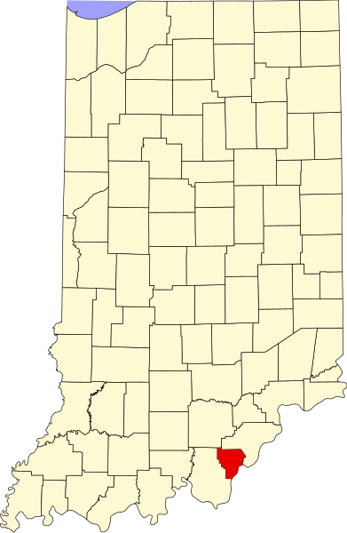
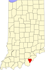
English: This is a locator map showing Floyd County in Indiana. For more information, see Commons:United States county locator maps. |
| 日期 | |
| 来源 |
自己的作品: English: The maps use data from nationalatlas.gov, specifically countyp020.tar.gz on the Raw Data Download page. The maps also use state outline data from statesp020.tar.gz. The Florida maps use hydrogm020.tar.gz to display Lake Okeechobee. |
| 作者 | David Benbennick |
许可协议[编辑]
| 我,本作品著作权人,释出本作品至公有领域。这适用于全世界。 在一些国家这可能不合法;如果是这样的话,那么: 我无条件地授予任何人以任何目的使用本作品的权利,除非这些条件是法律规定所必需的。 |
文件历史
点击某个日期/时间查看对应时刻的文件。
| 日期/时间 | 缩略图 | 大小 | 用户 | 备注 | |
|---|---|---|---|---|---|
| 当前 | 2006年2月12日 (日) 12:10 | | 2,887 × 4,423(56 KB) | David Benbennick(留言 | 贡献) | {{subst:User:Dbenbenn/clm|county=Floyd County|state=Indiana}} |
您不可以覆盖此文件。
文件用途
以下16个页面使用本文件:
- Category:Agriculture in Floyd County, Indiana
- Category:Art of Floyd County, Indiana
- Category:Bodies of water in Floyd County, Indiana
- Category:Bridges in Floyd County, Indiana
- Category:Education in Floyd County, Indiana
- Category:Floyd County, Indiana
- Category:Geography of Floyd County, Indiana
- Category:Historic districts in Floyd County, Indiana
- Category:Maps of Floyd County, Indiana
- Category:National Register of Historic Places in Floyd County, Indiana
- Category:People of Floyd County, Indiana
- Category:Populated places in Floyd County, Indiana
- Category:Rivers of Floyd County, Indiana
- Category:Structures in Floyd County, Indiana
- Category:Towns in Floyd County, Indiana
- Category:Visitor attractions in Floyd County, Indiana
全域文件用途
以下其他wiki使用此文件:
- ar.wikipedia.org上的用途
- azb.wikipedia.org上的用途
- bg.wikipedia.org上的用途
- bpy.wikipedia.org上的用途
- cdo.wikipedia.org上的用途
- ceb.wikipedia.org上的用途
- ce.wikipedia.org上的用途
- cy.wikipedia.org上的用途
- de.wikipedia.org上的用途
- en.wikipedia.org上的用途
- List of counties in Indiana
- Floyd County, Indiana
- Galena, Indiana
- Georgetown, Floyd County, Indiana
- Greenville, Indiana
- New Albany, Indiana
- Floyds Knobs, Indiana
- Mount St. Francis, Indiana
- New Albany Downtown Historic District (Indiana)
- East Spring Street Historic District
- Edwardsville, Indiana
- Template:Floyd County, Indiana
- Franklin Township, Floyd County, Indiana
- Georgetown Township, Floyd County, Indiana
- Greenville Township, Floyd County, Indiana
- Lafayette Township, Floyd County, Indiana
- New Albany Township, Floyd County, Indiana
- Template:FloydCountyIN-geo-stub
- Navilleton, Indiana
- Saint Joseph, Floyd County, Indiana
- Saint Marys, Floyd County, Indiana
- Scottsville, Indiana
- Duncan, Indiana
- User:Nyttend/County templates/IN/1
- Blackiston Mill, Indiana
- National Register of Historic Places listings in Floyd County, Indiana
- Category:Populated places in Floyd County, Indiana
- List of Indiana state historical markers in Floyd County
- Silver Hills, Indiana
- Buchanan, Indiana
- User:Br.gamache/sandbox
- Hedden's Grove Historic District
- Georgetown Historic District (Georgetown, Indiana)
- es.wikipedia.org上的用途
查看本文件的更多全域用途。