File:Map of Indiana highlighting Porter County.svg
Ir a la navegación
Ir a la búsqueda

Tamaño de esta previsualización PNG del archivo SVG: 391 × 599 píxeles. Otras resoluciones: 156 × 240 píxeles | 313 × 480 píxeles | 501 × 768 píxeles | 668 × 1024 píxeles | 1337 × 2048 píxeles | 722 × 1106 píxeles.
Archivo original (archivo SVG, nominalmente 722 × 1106 píxeles, tamaño de archivo: 42 kB)
Leyendas
Leyendas
Añade una explicación corta acerca de lo que representa este archivo
Resumen
[editar]
| Descripción |
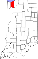
English: This is a locator map showing Porter County in Indiana. For more information, see Commons:United States county locator maps. |
| Fecha | |
| Fuente |
Trabajo propio: English: The maps use data from nationalatlas.gov, specifically countyp020.tar.gz on the Raw Data Download page. The maps also use state outline data from statesp020.tar.gz. The Florida maps use hydrogm020.tar.gz to display Lake Okeechobee. |
| Autor | David Benbennick |
Licencia
[editar]
| Yo, el titular de los derechos de autor de esta obra, lo libero al dominio público. Esto aplica en todo el mundo. En algunos países esto puede no ser legalmente factible; si ello ocurriese: Concedo a cualquier persona el derecho de usar este trabajo para cualquier propósito, sin ningún tipo de condición al menos que éstas sean requeridas por la ley. |
Historial del archivo
Haz clic sobre una fecha y hora para ver el archivo tal como apareció en ese momento.
| Fecha y hora | Miniatura | Dimensiones | Usuario | Comentario | |
|---|---|---|---|---|---|
| actual | 14:47 25 jun 2024 | | 722 × 1106 (42 kB) | Nux (discusión | contribs.) | uniform colors with good contrast |
| 20:41 19 jun 2024 |  | 722 × 1106 (42 kB) | Nux (discusión | contribs.) | fix rendering (remove clipping) | |
| 12:11 12 feb 2006 |  | 2887 × 4423 (56 kB) | David Benbennick (discusión | contribs.) | {{subst:User:Dbenbenn/clm|county=Porter County|state=Indiana}} |
No puedes sobrescribir este archivo.
Usos del archivo
Las siguientes páginas usan este archivo:
- Category:Births in Porter County, Indiana
- Category:Deaths in Porter County, Indiana
- Category:Education in Porter County, Indiana
- Category:Geography of Porter County, Indiana
- Category:Historic districts in Porter County, Indiana
- Category:Maps of Porter County, Indiana
- Category:National Register of Historic Places in Porter County, Indiana
- Category:People of Porter County, Indiana
- Category:Porter County, Indiana
Uso global del archivo
Las wikis siguientes utilizan este archivo:
- Uso en ar.wikipedia.org
- Uso en bg.wikipedia.org
- Uso en bpy.wikipedia.org
- Uso en ceb.wikipedia.org
- Uso en cy.wikipedia.org
- Uso en de.wikipedia.org
- Uso en en.wikipedia.org
- List of counties in Indiana
- Porter County, Indiana
- Lakes of the Four Seasons, Indiana
- Beverly Shores, Indiana
- Burns Harbor, Indiana
- Chesterton, Indiana
- Dune Acres, Indiana
- Hebron, Indiana
- Kouts, Indiana
- Ogden Dunes, Indiana
- Porter, Indiana
- South Haven, Indiana
- Town of Pines, Indiana
- Valparaiso, Indiana
- Boone Grove, Indiana
- Boone Township, Porter County, Indiana
- Center Township, Porter County, Indiana
- Jackson Township, Porter County, Indiana
- Liberty Township, Porter County, Indiana
- Morgan Township, Porter County, Indiana
- Pine Township, Porter County, Indiana
- Pleasant Township, Porter County, Indiana
- Portage Township, Porter County, Indiana
- Porter Township, Porter County, Indiana
- Union Township, Porter County, Indiana
- Washington Township, Porter County, Indiana
- Westchester Township, Porter County, Indiana
- Template:Porter County, Indiana
- Template:PorterCountyIN-geo-stub
- Portage, Indiana
- Wheeler, Indiana
- User:Nyttend/County templates/IN/2
Ver más uso global de este archivo.