File:Map of Indiana highlighting Posey County.svg
跳至導覽
跳至搜尋

此 SVG 檔案的 PNG 預覽的大小:391 × 599 像素。 其他解析度:156 × 240 像素 | 313 × 480 像素 | 501 × 768 像素 | 668 × 1,024 像素 | 1,337 × 2,048 像素 | 2,887 × 4,423 像素。
原始檔案 (SVG 檔案,表面大小:2,887 × 4,423 像素,檔案大小:56 KB)
說明
說明
添加單行說明來描述出檔案所代表的內容
摘要
[編輯]
| 描述 |
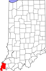
English: This is a locator map showing Posey County in Indiana. For more information, see Commons:United States county locator maps. |
| 日期 | |
| 來源 |
自己的作品: English: The maps use data from nationalatlas.gov, specifically countyp020.tar.gz on the Raw Data Download page. The maps also use state outline data from statesp020.tar.gz. The Florida maps use hydrogm020.tar.gz to display Lake Okeechobee. |
| 作者 | David Benbennick |
授權條款
[編輯]
| 我,此作品的版權所有人,釋出此作品至公共領域。此授權條款在全世界均適用。 這可能在某些國家不合法,如果是的話: 我授予任何人有權利使用此作品於任何用途,除受法律約束外,不受任何限制。 |
檔案歷史
點選日期/時間以檢視該時間的檔案版本。
| 日期/時間 | 縮圖 | 尺寸 | 用戶 | 備註 | |
|---|---|---|---|---|---|
| 目前 | 2006年2月12日 (日) 12:11 | | 2,887 × 4,423(56 KB) | David Benbennick(對話 | 貢獻) | {{subst:User:Dbenbenn/clm|county=Posey County|state=Indiana}} |
無法覆蓋此檔案。
檔案用途
下列8個頁面有用到此檔案:
- Category:Births in Posey County, Indiana
- Category:Deaths in Posey County, Indiana
- Category:Historic districts in Posey County, Indiana
- Category:Maps of Posey County, Indiana
- Category:National Register of Historic Places in Posey County, Indiana
- Category:People of Posey County, Indiana
- Category:Posey County, Indiana
- Category:Posey County, Indiana Image by Chris Light
全域檔案使用狀況
以下其他 wiki 使用了這個檔案:
- ar.wikipedia.org 的使用狀況
- azb.wikipedia.org 的使用狀況
- bg.wikipedia.org 的使用狀況
- bpy.wikipedia.org 的使用狀況
- cdo.wikipedia.org 的使用狀況
- ceb.wikipedia.org 的使用狀況
- ce.wikipedia.org 的使用狀況
- cy.wikipedia.org 的使用狀況
- de.wikipedia.org 的使用狀況
- en.wikipedia.org 的使用狀況
- List of counties in Indiana
- Posey County, Indiana
- Cynthiana, Indiana
- Griffin, Indiana
- Mount Vernon, Indiana
- New Harmony, Indiana
- Poseyville, Indiana
- Harmonie State Park
- Template:Posey County, Indiana
- Bethel Township, Posey County, Indiana
- Black Township, Posey County, Indiana
- Center Township, Posey County, Indiana
- Harmony Township, Posey County, Indiana
- Lynn Township, Posey County, Indiana
- Marrs Township, Posey County, Indiana
- Point Township, Posey County, Indiana
- Robb Township, Posey County, Indiana
- Robinson Township, Posey County, Indiana
- Smith Township, Posey County, Indiana
- Template:PoseyCountyIN-geo-stub
- Wadesville, Indiana
- User:Nyttend/County templates/IN/2
- Hovey Lake Fish and Wildlife Area
- National Register of Historic Places listings in Posey County, Indiana
- Solitude, Indiana
- Black River (Indiana)
- Hovey Lake-Klein Archeological Site
- Welborn Village Archeological Site
- Wikipedia:Graphics Lab/Map workshop/Archive/Jan 2011
- Category:Populated places in Posey County, Indiana
- List of Indiana state historical markers in Posey County
- Blairsville, Indiana
- Parkers Settlement, Indiana
- Rapture, Indiana
檢視此檔案的更多全域使用狀況。