File:Map of Minnesota highlighting Goodhue County.svg
Salta a la navegació
Salta a la cerca

Mida d'aquesta previsualització PNG del fitxer SVG: 527 × 600 píxels. Altres resolucions: 211 × 240 píxels | 422 × 480 píxels | 675 × 768 píxels | 900 × 1.024 píxels | 1.800 × 2.048 píxels | 1.045 × 1.189 píxels.
Fitxer original (fitxer SVG, nominalment 1.045 × 1.189 píxels, mida del fitxer: 67 Ko)
Llegendes
Llegendes
Afegeix una explicació d'una línia del que representa aquest fitxer
Resum
[modifica]
| Descripció |
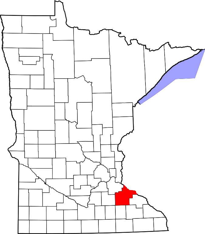
English: This is a locator map showing Goodhue County in Minnesota. For more information, see Commons:United States county locator maps. |
| Data | |
| Font |
Treball propi: English: The maps use data from nationalatlas.gov, specifically countyp020.tar.gz on the Raw Data Download page. The maps also use state outline data from statesp020.tar.gz. The Florida maps use hydrogm020.tar.gz to display Lake Okeechobee. |
| Autor | David Benbennick |
Llicència
[modifica]
| Jo, el titular del copyright d'aquesta obra, l'allibero al domini públic. Això s'aplica a tot el món. En alguns països això pot no ser legalment possible, en tal cas: Jo faig concessió a tothom del dret d'usar aquesta obra per a qualsevol propòsit, sense cap condició llevat d'aquelles requerides per la llei. |
Historial del fitxer
Cliqueu una data/hora per veure el fitxer tal com era aleshores.
| Data/hora | Miniatura | Dimensions | Usuari/a | Comentari | |
|---|---|---|---|---|---|
| actual | 02:15, 25 juny 2024 | | 1.045 × 1.189 (67 Ko) | Nux (discussió | contribucions) | fix rendering (remove clipping) |
| 13:13, 12 feb 2006 |  | 5.746 × 6.539 (104 Ko) | David Benbennick (discussió | contribucions) | {{subst:User:Dbenbenn/clm|county=Goodhue County|state=Minnesota|type=county}} | |
| 13:02, 12 feb 2006 |  | 5.746 × 6.539 (104 Ko) | David Benbennick (discussió | contribucions) | {{subst:User:Dbenbenn/clm|county=Goodhue County|state=Minnesota|type=county}} |
No podeu sobreescriure aquest fitxer.
Ús del fitxer
Les 6 pàgines següents utilitzen aquest fitxer:
Ús global del fitxer
Utilització d'aquest fitxer en altres wikis:
- Utilització a ar.wikipedia.org
- Utilització a bg.wikipedia.org
- Utilització a bpy.wikipedia.org
- Utilització a ca.wikipedia.org
- Utilització a cdo.wikipedia.org
- Utilització a ceb.wikipedia.org
- Utilització a cy.wikipedia.org
- Utilització a da.wikipedia.org
- Utilització a de.wikipedia.org
- Utilització a en.wikipedia.org
- List of counties in Minnesota
- Goodhue County, Minnesota
- Belle Creek Township, Goodhue County, Minnesota
- Belvidere Township, Goodhue County, Minnesota
- Cannon Falls, Minnesota
- Cannon Falls Township, Goodhue County, Minnesota
- Cherry Grove Township, Goodhue County, Minnesota
- Featherstone Township, Goodhue County, Minnesota
- Florence Township, Goodhue County, Minnesota
- Goodhue, Minnesota
- Goodhue Township, Goodhue County, Minnesota
- Hay Creek Township, Goodhue County, Minnesota
- Holden Township, Goodhue County, Minnesota
- Kenyon, Minnesota
- Kenyon Township, Goodhue County, Minnesota
- Leon Township, Goodhue County, Minnesota
- Minneola Township, Goodhue County, Minnesota
- Pine Island Township, Goodhue County, Minnesota
- Red Wing, Minnesota
- Roscoe Township, Goodhue County, Minnesota
Vegeu més usos globals d'aquest fitxer.