File:Map of New Mexico highlighting Catron County.svg
跳至導覽
跳至搜尋

此 SVG 檔案的 PNG 預覽的大小:539 × 599 像素。 其他解析度:216 × 240 像素 | 432 × 480 像素 | 691 × 768 像素 | 921 × 1,024 像素 | 1,842 × 2,048 像素 | 5,677 × 6,312 像素。
原始檔案 (SVG 檔案,表面大小:5,677 × 6,312 像素,檔案大小:35 KB)
說明
說明
添加單行說明來描述出檔案所代表的內容
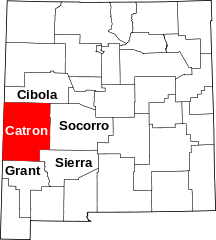
This is a locator map showing Catron County in New Mexico.
David Benbennick made this map. For more information, see Commons:United States county locator maps. Or see any of the New Mexico county locator maps: Bernalillo · Catron · Chaves · Cibola · Colfax · Curry · De Baca · Doña Ana · Eddy · Grant · Guadalupe · Harding · Hidalgo · Lea · Lincoln · Los Alamos · Luna · McKinley · Mora · Otero · Quay · Rio Arriba · Roosevelt · Sandoval · San Juan · San Miguel · Santa Fe · Sierra · Socorro · Taos · Torrance · Union · Valencia
| 我,此作品的版權所有人,釋出此作品至公共領域。此授權條款在全世界均適用。 這可能在某些國家不合法,如果是的話: 我授予任何人有權利使用此作品於任何用途,除受法律約束外,不受任何限制。 |
檔案歷史
點選日期/時間以檢視該時間的檔案版本。
| 日期/時間 | 縮圖 | 尺寸 | 使用者 | 備註 | |
|---|---|---|---|---|---|
| 目前 | 2024年7月6日 (六) 00:02 | | 5,677 × 6,312(35 KB) | Nux(留言 | 貢獻) | fix rendering (remove clipping), uniform colors |
| 2009年4月9日 (四) 15:47 |  | 5,677 × 6,312(36 KB) | Rfc1394(留言 | 貢獻) | Add names of adjacent counties | |
| 2006年2月12日 (日) 15:30 |  | 5,677 × 6,312(31 KB) | David Benbennick(留言 | 貢獻) | {{subst:User:Dbenbenn/clm|county=Catron County|state=New Mexico|type=county}} |
無法覆蓋此檔案。
檔案用途
下列6個頁面有用到此檔案:
全域檔案使用狀況
以下其他 wiki 使用了這個檔案:
- ar.wikipedia.org 的使用狀況
- bg.wikipedia.org 的使用狀況
- bpy.wikipedia.org 的使用狀況
- cdo.wikipedia.org 的使用狀況
- ceb.wikipedia.org 的使用狀況
- ce.wikipedia.org 的使用狀況
- cy.wikipedia.org 的使用狀況
- de.wikipedia.org 的使用狀況
- en.wikipedia.org 的使用狀況
- List of counties in New Mexico
- Catron County, New Mexico
- Reserve, New Mexico
- Aragon, New Mexico
- Datil, New Mexico
- Acoma Indian Reservation
- Pie Town, New Mexico
- Lost Adams Diggings
- Luna, New Mexico
- Mogollon, New Mexico
- Alma, New Mexico
- Glenwood, New Mexico
- San Francisco Plaza, New Mexico
- Quemado, New Mexico
- Apache Creek, New Mexico
- Cruzville, New Mexico
- Old Horse Springs, New Mexico
- Cooney, New Mexico
- Clairmont, New Mexico
- Pleasanton, New Mexico
- Red Hill, New Mexico
- Template:Catron County, New Mexico
- User:Nyttend/County templates/NM
- Category:Populated places in Catron County, New Mexico
- National Register of Historic Places listings in Catron County, New Mexico
- Escudilla Bonita, New Mexico
- Homestead, New Mexico
- Lower Frisco, New Mexico
- Middle Frisco, New Mexico
- Rancho Grande, New Mexico
- Rivers, New Mexico
- Mangas, New Mexico
- Patterson, New Mexico
- Greens Gap, New Mexico
- User:AridCeption/sandbox
- File talk:Map of New Mexico highlighting Catron County.svg
檢視此檔案的更多全域使用狀況。