File:Map of New York highlighting Herkimer County.svg
Aller à la navigation
Aller à la recherche

Taille de cet aperçu PNG pour ce fichier SVG : 787 × 600 pixels. Autres résolutions : 315 × 240 pixels | 630 × 480 pixels | 1 008 × 768 pixels | 1 280 × 976 pixels | 2 560 × 1 951 pixels | 6 599 × 5 030 pixels.
Fichier d’origine (Fichier SVG, nominalement de 6 599 × 5 030 pixels, taille : 112 kio)
Légendes
Légendes
Ajoutez en une ligne la description de ce que représente ce fichier
Description
[modifier]
| Description |
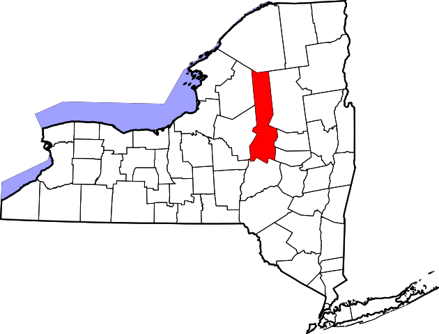
English: This is a locator map showing Herkimer County in New York. For more information, see Commons:United States county locator maps. |
| Date | |
| Source |
Travail personnel: English: The maps use data from nationalatlas.gov, specifically countyp020.tar.gz on the Raw Data Download page. The maps also use state outline data from statesp020.tar.gz. The Florida maps use hydrogm020.tar.gz to display Lake Okeechobee. |
| Auteur | David Benbennick |
Conditions d’utilisation
[modifier]
| Moi, propriétaire des droits d’auteur sur cette œuvre, la place dans le domaine public. Ceci s'applique dans le monde entier. Dans certains pays, ceci peut ne pas être possible ; dans ce cas : J’accorde à toute personne le droit d’utiliser cette œuvre dans n’importe quel but, sans aucune condition, sauf celles requises par la loi. |
Historique du fichier
Cliquer sur une date et heure pour voir le fichier tel qu'il était à ce moment-là.
| Date et heure | Vignette | Dimensions | Utilisateur | Commentaire | |
|---|---|---|---|---|---|
| actuel | 12 février 2006 à 15:32 | | 6 599 × 5 030 (112 kio) | David Benbennick (d | contributions) | {{subst:User:Dbenbenn/clm|county=Herkimer County|state=New York|type=county}} |
Vous ne pouvez pas remplacer ce fichier.
Utilisations locales du fichier
Les 11 pages suivantes utilisent ce fichier :
- Category:Bridges in Herkimer County, New York
- Category:Cemeteries in Herkimer County, New York
- Category:Deaths in Herkimer County, New York
- Category:Geography of Herkimer County, New York
- Category:Herkimer County, New York
- Category:Maps of Herkimer County, New York
- Category:New York State Register of Historic Places in Herkimer County
- Category:People of Herkimer County, New York
- Category:Towns in Herkimer County, New York
- Category:Views of Herkimer County, New York
- Category:Villages in Herkimer County, New York
Utilisations du fichier sur d’autres wikis
Les autres wikis suivants utilisent ce fichier :
- Utilisation sur ar.wikipedia.org
- مقاطعة هيركايمر (نيويورك)
- ليتل فولز (نيويورك)
- إيليون (نيويورك)
- دولغيفيل (نيويورك)
- قرية هريكيمر (نيويورك)
- كولد بروك (نيويورك)
- ميدلفيل (نيويورك)
- وست وينفيلد (نيويورك)
- قرية فرانكفورت (نيويورك)
- قرية نيوبورت (نيويورك)
- كولومبيا (نيويورك)
- دانوبي (نيويورك)
- فيرفيلد (نيويورك)
- فرانكفورت (نيويورك)
- جيرمان فلاتس (نيويورك)
- هيركيمر (نيويورك)
- ليتشفيلد (نيويورك)
- ليتل فالس (نيويورك)
- مانهيم (نيويورك)
- نيوبورت (نيويورك)
- نورواي (نيويورك)
- أوهايو (نيويورك)
- موهوك (نيويورك)
- قالب:مقاطعة هيركايمر (نيويورك)
- Utilisation sur bg.wikipedia.org
- Utilisation sur bpy.wikipedia.org
- Utilisation sur ca.wikipedia.org
- Utilisation sur cdo.wikipedia.org
- Utilisation sur ceb.wikipedia.org
- Utilisation sur ce.wikipedia.org
- Utilisation sur cs.wikipedia.org
- Utilisation sur cy.wikipedia.org
- Utilisation sur de.wikipedia.org
- Utilisation sur en.wikipedia.org
Voir davantage sur l’utilisation globale de ce fichier.