File:Map of New York highlighting Richmond County.svg
Here nagîvasyonê
Here lêgerînê

Size of this PNG preview of this SVG file: 787 × 600 pîksel. Resolusyonên din: 315 × 240 pîksel | 630 × 480 pîksel | 1008 × 768 pîksel | 1280 × 976 pîksel | 2560 × 1951 pîksel | 6599 × 5030 pîksel.
Dosyeya orjînal (Daneya SVG, mezinbûna rast: 6599 × 5030 pixel; mezinbûna daneyê: 112 KB)
Captions
Captions
Add a one-line explanation of what this file represents
Danasîn[biguhêre]
| Danasîn |
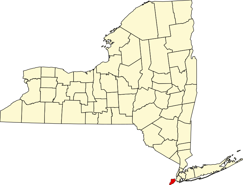
English: This is a locator map showing Richmond County in New York. For more information, see Commons:United States county locator maps. |
| Dîrok | |
| Çavkanî |
Min çêkir: English: The maps use data from nationalatlas.gov, specifically countyp020.tar.gz on the Raw Data Download page. The maps also use state outline data from statesp020.tar.gz. The Florida maps use hydrogm020.tar.gz to display Lake Okeechobee. |
| Xwedî | David Benbennick |
Lîsans[biguhêre]
| I, the copyright holder of this work, release this work into the public domain. This applies worldwide. In some countries this may not be legally possible; if so: I grant anyone the right to use this work for any purpose, without any conditions, unless such conditions are required by law. |
Dîroka daneyê
Ji bo dîtina guhartoya wê demê bişkoka dîrokê bitikîne.
| Dîrok/Katjimêr | Wêneyê biçûk | Mezinahî | Bikarhêner | Şirove | |
|---|---|---|---|---|---|
| niha | 15:33, 12 sibat 2006 | | 6599 x 5030 (112 KB) | David Benbennick (gotûbêj | beşdarî) | {{subst:User:Dbenbenn/clm|county=Richmond County|state=New York|type=county}} |
Tu nikarî cardin li ser vê dosyeyê binivîsînî.
Bikaranîna pelê
Ev 2 rûpel li jêr vê dosyeyê bi kar tînin:
Bikaranîna gerdûnî ya pelê
Ev wîkiyên di rêzê de vê pelê bi kar tînin:
- Bikaranîna di azb.wikipedia.org de
- Bikaranîna di bpy.wikipedia.org de
- Bikaranîna di cy.wikipedia.org de
- Bikaranîna di de.wikipedia.org de
- Bikaranîna di en.wikipedia.org de
- List of counties in New York
- Richmondtown, Staten Island
- Isle of Meadows
- Prall's Island
- Stapleton Heights, Staten Island
- Castleton, Staten Island
- Arrochar, Staten Island
- Richmond Creek (Fresh Kills)
- Wikipedia:WikiProject New York City
- Annadale, Staten Island
- Richmond Valley, Staten Island
- Bay Terrace, Staten Island
- Sunnyside, Staten Island
- Concord, Staten Island
- Meiers Corners, Staten Island
- Ward Hill, Staten Island
- Emerson Hill, Staten Island
- Egbertville, Staten Island
- Greenridge, Staten Island
- Randall Manor, Staten Island
- Shore Acres, Staten Island
- Brighton Heights, Staten Island
- Port Ivory, Staten Island
- National Register of Historic Places listings in Staten Island
- Aspen Knolls
- Manor Heights, Staten Island
- Tappen Park
- Long Pond Park
- Bloomingdale Park
- Wolfe's Pond Park
- New Creek (Staten Island)
- Template:StatenIsland-geo-stub
- Willowbrook Park
- Arlington, Staten Island
- Chelsea, Staten Island
- Old Place, Staten Island
- Southfield, Staten Island
- Middletown, Staten Island
- Westfield, Staten Island
- Northfield, Staten Island
- Fresh Kills
- Tompkins Circle
- Ingram Woods
- User:AridCeption/sandbox
Zêdetir bikaranîna global a vê pelê bibîne.