File:Map of New York highlighting Richmond County.svg
跳转到导航
跳转到搜索

此SVG文件的PNG预览的大小:787 × 600像素。 其他分辨率:315 × 240像素 | 630 × 480像素 | 1,008 × 768像素 | 1,280 × 976像素 | 2,560 × 1,951像素 | 6,599 × 5,030像素。
原始文件 (SVG文件,尺寸为6,599 × 5,030像素,文件大小:112 KB)
说明
说明
添加一行文字以描述该文件所表现的内容
摘要[编辑]
| 描述 |
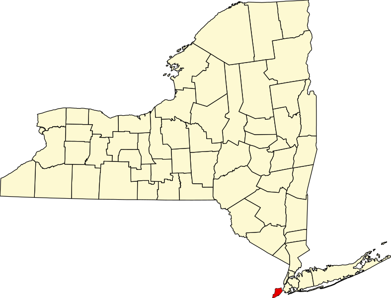
English: This is a locator map showing Richmond County in New York. For more information, see Commons:United States county locator maps. |
| 日期 | |
| 来源 |
自己的作品: English: The maps use data from nationalatlas.gov, specifically countyp020.tar.gz on the Raw Data Download page. The maps also use state outline data from statesp020.tar.gz. The Florida maps use hydrogm020.tar.gz to display Lake Okeechobee. |
| 作者 | David Benbennick |
许可协议[编辑]
| 我,本作品著作权人,释出本作品至公有领域。这适用于全世界。 在一些国家这可能不合法;如果是这样的话,那么: 我无条件地授予任何人以任何目的使用本作品的权利,除非这些条件是法律规定所必需的。 |
文件历史
点击某个日期/时间查看对应时刻的文件。
| 日期/时间 | 缩略图 | 大小 | 用户 | 备注 | |
|---|---|---|---|---|---|
| 当前 | 2006年2月12日 (日) 15:33 | | 6,599 × 5,030(112 KB) | David Benbennick(留言 | 贡献) | {{subst:User:Dbenbenn/clm|county=Richmond County|state=New York|type=county}} |
您不可以覆盖此文件。
文件用途
以下2个页面使用本文件:
全域文件用途
以下其他wiki使用此文件:
- azb.wikipedia.org上的用途
- bpy.wikipedia.org上的用途
- cy.wikipedia.org上的用途
- de.wikipedia.org上的用途
- en.wikipedia.org上的用途
- List of counties in New York
- Richmondtown, Staten Island
- Isle of Meadows
- Prall's Island
- Stapleton Heights, Staten Island
- Castleton, Staten Island
- Arrochar, Staten Island
- Richmond Creek (Fresh Kills)
- Wikipedia:WikiProject New York City
- Annadale, Staten Island
- Richmond Valley, Staten Island
- Bay Terrace, Staten Island
- Sunnyside, Staten Island
- Concord, Staten Island
- Meiers Corners, Staten Island
- Ward Hill, Staten Island
- Emerson Hill, Staten Island
- Egbertville, Staten Island
- Greenridge, Staten Island
- Randall Manor, Staten Island
- Shore Acres, Staten Island
- Brighton Heights, Staten Island
- Port Ivory, Staten Island
- National Register of Historic Places listings in Staten Island
- Aspen Knolls
- Manor Heights, Staten Island
- Tappen Park
- Long Pond Park
- Bloomingdale Park
- Wolfe's Pond Park
- New Creek (Staten Island)
- Template:StatenIsland-geo-stub
- Willowbrook Park
- Arlington, Staten Island
- Chelsea, Staten Island
- Old Place, Staten Island
- Southfield, Staten Island
- Middletown, Staten Island
- Westfield, Staten Island
- Northfield, Staten Island
- Fresh Kills
- Tompkins Circle
- Ingram Woods
- User:AridCeption/sandbox
查看本文件的更多全域用途。