File:Map of Operation Eagle Pull evacuation sites.jpg
跳转到导航
跳转到搜索
没有更高的分辨率。
Map_of_Operation_Eagle_Pull_evacuation_sites.jpg (600 × 552像素,文件大小:95 KB,MIME类型:image/jpeg)
说明
说明
添加一行文字以描述该文件所表现的内容
摘要
[编辑]
| 描述 |
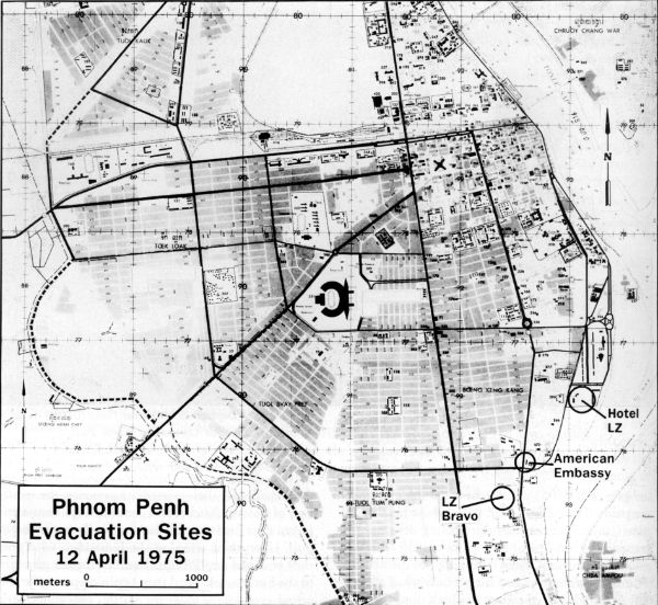
English: Map of possible helicopter landing zones for use in Operation Eagle Pull |
| 日期 | |
| 来源 | http://www.history.navy.mil/index.html |
| 作者 | US Navy |
许可协议
[编辑]
 | ||
| 本文件已被确认为免除已知的著作权法限制(包括所有相关权利)。 | ||
文件历史
点击某个日期/时间查看对应时刻的文件。
| 日期/时间 | 缩略图 | 大小 | 用户 | 备注 | |
|---|---|---|---|---|---|
| 当前 | 2010年2月7日 (日) 09:11 | | 600 × 552(95 KB) | Mztourist(留言 | 贡献) | {{Information |Description={{en|1=Map of possible helicopter landing zones for use in Operation Eagle Pull}} |Source=http://www.history.navy.mil/index.html |Author=US Navy |Date=1975-04 |Permission= |other_versions= }} Category:Operation Eagle Pull [ |
您不可以覆盖此文件。
文件用途
没有页面使用本文件。
全域文件用途
以下其他wiki使用此文件:
- br.wikipedia.org上的用途
- de.wikipedia.org上的用途
- en.wikipedia.org上的用途
- ru.wikipedia.org上的用途
- vi.wikipedia.org上的用途
- zh.wikipedia.org上的用途