File:Map of Russia - Siberian Federal District (2018 composition).svg
跳转到导航
跳转到搜索

此SVG文件的PNG预览的大小:800 × 462像素。 其他分辨率:320 × 185像素 | 640 × 369像素 | 1,024 × 591像素 | 1,280 × 738像素 | 2,560 × 1,477像素 | 1,092 × 630像素。
原始文件 (SVG文件,尺寸为1,092 × 630像素,文件大小:61 KB)
说明
说明
添加一行文字以描述该文件所表现的内容
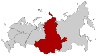
Map of the Siberian Federal District within Russia.

|
本地图上显示的边界是实际(de facto)情况。这只是对主题多种观点中的一种(参见COM:NPOV)。 |
摘要[编辑]
.svg&action=edit§ion=1)
| 描述 |
English: Map Russia highlighting the Siberian Federal districts as of 2018-11-03. Español: Ubicación del Distrito Federal de Siberia en la Federación Rusa Русский: Сибирский федеральный округ
English: Map of Russian federal districts, as of 2016-11-04 |
| 日期 | |
| 来源 |
本檔案衍生自: |
| 作者 |
| 这是一张修改过的图片,这意味着它已在原版本的基础上通过软件进行了编辑,改动内容:Removed Buryatia and Zabaykalsky Krai。其原始版本为:Map of Russian districts, 2018-11-04.svg。修改者:Seryo93。
|
许可协议[编辑]
.svg&action=edit§ion=2)
本文件采用知识共享署名-相同方式共享 2.5 通用许可协议授权。
- 您可以自由地:
- 共享 – 复制、发行并传播本作品
- 修改 – 改编作品
- 惟须遵守下列条件:
- 署名 – 您必须对作品进行署名,提供授权条款的链接,并说明是否对原始内容进行了更改。您可以用任何合理的方式来署名,但不得以任何方式表明许可人认可您或您的使用。
- 相同方式共享 – 如果您再混合、转换或者基于本作品进行创作,您必须以与原先许可协议相同或相兼容的许可协议分发您贡献的作品。
原始上传日志[编辑]
.svg&action=edit§ion=3)
This image is a derivative work of the following images:
- File:Map of Russia - Siberian Federal District.svg licensed with Cc-by-sa-2.5
- 2015-03-10T14:20:17Z Knyaz-1988 1092x630 (97464 Bytes) Reverted to version as of 22:16, 3 November 2014
- 2014-11-04T01:32:14Z Fry1989 1092x630 (120528 Bytes) NPOV issue.
- 2014-11-03T22:16:30Z Knyaz-1988 1092x630 (97464 Bytes) New version
- 2010-01-21T22:27:35Z Denhud 1092x630 (120528 Bytes) On 2010-01-19 Southern Federal District split in two, with its former southern territories forming new North Caucasian Federal District.
- 2008-03-03T23:36:52Z Lokal Profil 1092x630 (114976 Bytes) {{Information |Description=Map Russia highlighting the Siberian [[:en:Federal districts of Russia|Federal districts]]. |Source=Based on [[:Image:Map of Russian subjects, 2008-03-01.svg|Map of Russian subjects, 2008-03-01.svg]
- File:Map of Russian districts, 2018-11-04.svg licensed with Cc-by-sa-2.5
Uploaded with derivativeFX
文件历史
点击某个日期/时间查看对应时刻的文件。
| 日期/时间 | 缩略图 | 大小 | 用户 | 备注 | |
|---|---|---|---|---|---|
| 当前 | 2018年11月4日 (日) 19:21 | | 1,092 × 630(61 KB) | Seryo93(留言 | 贡献) | == {{int:filedesc}} == {{Information |Description={{en|Map Russia highlighting the Siberian Federal districts as of 2018-11-03.}} {{es|Ubicación del Distrito Federal de Siberia en la Federación Rusa}} {{Ru|Сибирский федеральный округ}} {{en|1=Map of Russian federal districts, as of 2016-11-04}} |date=2018-11-04 |Source={{Derived from|Map of Russia - Siberian Federal District.svg|Map of Russian districts, 2018-11-04.svg|display=50}} |Date=2018-11-04 19:21 (U... |
您不可以覆盖此文件。
文件用途
全域文件用途
以下其他wiki使用此文件:
- ar.wikipedia.org上的用途
- ast.wikipedia.org上的用途
- az.wikipedia.org上的用途
- be.wikipedia.org上的用途
- ca.wikipedia.org上的用途
- cs.wikipedia.org上的用途
- en.wikipedia.org上的用途
- en.wikinews.org上的用途
- eo.wikipedia.org上的用途
- et.wikipedia.org上的用途
- fi.wikipedia.org上的用途
- Altain tasavalta
- Tuva
- Hakassia
- Altain aluepiiri
- Omskin alue
- Tšeljabinskin alue
- Jamalin Nenetsia
- Hanti-Mansia
- Irkutskin alue
- Kemerovon alue
- Kurganin alue
- Novosibirskin alue
- Sverdlovskin alue
- Tomskin alue
- Tjumenin alue
- Uralin federaatiopiiri
- Siperian federaatiopiiri
- Malline:Siperian federaatiopiiri
- Malline:Uralin federaatiopiiri
- frr.wikipedia.org上的用途
查看本文件的更多全域用途。
.svg)
.svg&oldid=728893454)