File:Map of Sealand with territorial waters-zh-classical.png

原始文件 (1,174 × 1,200像素,文件大小:140 KB,MIME类型:image/png)
说明
说明
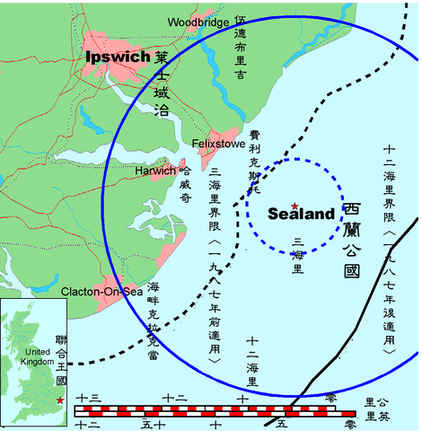
This is a map of the coast of England near Ipswich, showing the location of Sealand. The boundaries of the territorial water of the United Kingdom are also drawn, both the 3 nautical mile limit (5.556km) before 1987 and the 12nm limit (22.22km) after 1987. The same radii are also given around Sealand.
Note that these boundaries are derived based on the circular distance from the coastline, and not copied from official maps. This map is not suitable for navigation or for determining the boundaries of the UK territorial waters for legal or other purposes.
- A vector graphic file can be found at Image:Map of Sealand with territorial waters.svg
- The OpenOffice.org source file can be found at Image:Map of Sealand with territorial waters.sxd
- See also Image:Map of Sealand.png for the map without the territorial waters
Originally uploaded to here.
The Classical Chinese Modification is made by User:Itsmine.
Map generated by DEMIS World Map Server and edited by Chris 73
| Licensing:
This image was created by Chris 73. The image is licensed under a dual license; please choose either of the two licenses below as desired. Attribution to Wikipedia or another project of the Wikimedia foundation is required for both licenses if the image is used outside of projects of the Wikimedia foundation. Attribution to me is not required.
本文件采用知识共享署名-相同方式共享 3.0 未本地化版本许可协议授权。 署名: Chris 73 / Wikimedia Commons
"I want to use the image. How do I do that?" You can use this image freely for any purpose, including commercial use, provided that you license it under one of the above licenses. My suggestion is to use the following text:
For privacy reasons please use only "Chris 73" as author. If necessary, please translate the text in your language. For electronic use please include the links in the text as shown, for printed use please print the text as shown. If you use the image I would appreciate it if you would let me know on my talk page, but this is not required as long as you follow one of the above licenses. |

文件历史
点击某个日期/时间查看对应时刻的文件。
| 日期/时间 | 缩略图 | 大小 | 用户 | 备注 | |
|---|---|---|---|---|---|
| 当前 | 2007年5月13日 (日) 07:10 | | 1,174 × 1,200(140 KB) | Itsmine(留言 | 贡献) | |
| 2007年5月13日 (日) 07:09 |  | 1,174 × 1,200(139 KB) | Itsmine(留言 | 贡献) | ||
| 2007年5月13日 (日) 07:03 |  | 1,174 × 1,200(140 KB) | Itsmine(留言 | 贡献) | Map of Sealand This is a map of the coast of England near Ipswich, showing the location of Sealand. The boundaries of the territorial water of the United Kingdom are also drawn, both the 3 nautical mile limit (5.556km) before 1987 and the 12nm limit (22. |
您不可以覆盖此文件。
文件用途
以下页面使用本文件:
全域文件用途
以下其他wiki使用此文件:
- zh.wikipedia.org上的用途