File:Map of Turkish Language.svg
出自Wikimedia Commons
跳至導覽
跳至搜尋
![File:Map of Turkish Language.svg](https://upload.wikimedia.org/wikipedia/commons/thumb/d/de/Map_of_Turkish_Language.svg/512px-Map_of_Turkish_Language.svg.png?20240415143456)
此 SVG 檔案的 PNG 預覽的大小:512 × 386 像素。 其他解析度:319 × 240 像素 | 637 × 480 像素 | 1,019 × 768 像素 | 1,280 × 965 像素 | 2,560 × 1,930 像素。
原始檔案 (SVG 檔案,表面大小:512 × 386 像素,檔案大小:468 KB)
檔案資訊
結構化資料
說明
說明
添加單行說明來描述出檔案所代表的內容
Türkçenin Statüsü
摘要
[編輯]描述Map of Turkish Language.svg |
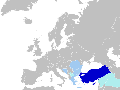
English: Status of Turkish Language.
Türkçe: Türkçenin Statüsü.
|
日期 | |
來源 | 自己的作品, blank map: File:Blank map of Europe (without disputed regions).svg by User:Nordwestern |
作者 | Jelican9 |
授權條款
[編輯]我,本作品的著作權持有者,決定用以下授權條款發佈本作品:
![]() ![]() |
此檔案在創用CC CC0 1.0 通用公有領域貢獻宣告之下分發。 |
在此宣告之下分發本作品者,已依據各國著作權法,在全世界放棄其對本作品所擁有的著作權及所有相關相似的法律權利,從而將本作品貢獻至公有領域。您可以複製、修改、分發和演示該作品,用於任何商業用途,所有這些都不需要請求授權。
http://creativecommons.org/publicdomain/zero/1.0/deed.enCC0Creative Commons Zero, Public Domain Dedicationfalsefalse |
檔案歷史
點選日期/時間以檢視該時間的檔案版本。
日期/時間 | 縮圖 | 尺寸 | 使用者 | 備註 | |
---|---|---|---|---|---|
目前 | 2024年4月15日 (一) 14:34 | ![]() | 512 × 386(468 KB) | Lionel Cristiano(留言 | 貢獻) | Update |
2022年9月1日 (四) 16:53 | ![]() | 512 × 386(468 KB) | Golden(留言 | 貢獻) | rmv countries with zero recognition (+outdated borders) | |
2021年4月26日 (一) 12:56 | ![]() | 512 × 386(450 KB) | Kurmanbek(留言 | 貢獻) | Fix minor bugs | |
2021年4月26日 (一) 12:54 | ![]() | 512 × 392(450 KB) | Kurmanbek(留言 | 貢獻) | Fix minor bugs | |
2021年4月26日 (一) 12:51 | ![]() | 512 × 392(502 KB) | Kurmanbek(留言 | 貢獻) | Uploaded own work with UploadWizard |
無法覆蓋此檔案。
檔案用途
下列5個頁面有用到此檔案:
全域檔案使用狀況
以下其他 wiki 使用了這個檔案:
- ace.wikipedia.org 的使用狀況
- af.wikipedia.org 的使用狀況
- an.wikipedia.org 的使用狀況
- ar.wikipedia.org 的使用狀況
- ary.wikipedia.org 的使用狀況
- arz.wikipedia.org 的使用狀況
- ast.wikipedia.org 的使用狀況
- avk.wikipedia.org 的使用狀況
- av.wikipedia.org 的使用狀況
- azb.wikipedia.org 的使用狀況
- az.wikipedia.org 的使用狀況
- ba.wikipedia.org 的使用狀況
- be-tarask.wikipedia.org 的使用狀況
- beta.wikiversity.org 的使用狀況
- be.wikipedia.org 的使用狀況
- bg.wikipedia.org 的使用狀況
- bn.wikipedia.org 的使用狀況
- bn.wikibooks.org 的使用狀況
- br.wikipedia.org 的使用狀況
- bxr.wikipedia.org 的使用狀況
- ca.wikipedia.org 的使用狀況
- cdo.wikipedia.org 的使用狀況
- ce.wikipedia.org 的使用狀況
- chr.wikipedia.org 的使用狀況
- ckb.wikipedia.org 的使用狀況
- cs.wikipedia.org 的使用狀況
- da.wikipedia.org 的使用狀況
- de.wikibooks.org 的使用狀況
- diq.wikipedia.org 的使用狀況
- el.wikipedia.org 的使用狀況
- eml.wikipedia.org 的使用狀況
- en.wikipedia.org 的使用狀況
- en.wikibooks.org 的使用狀況
檢視此檔案的更多全域使用狀況。
詮釋資料
此檔案中包含其他資訊,這些資訊可能是由數位相機或掃描器在建立或數位化過程中所新增的。若檔案自原始狀態已被修改,一些詳細資料可能無法完整反映出已修改的檔案。
影像標題 | A blank Map of Europe. Every country has an id which is its ISO-3166-1-ALPHA2 code in lower case.
Members of the EU have a class="eu", countries in europe (which I found turkey to be but russia not) have a class="europe". Certain countries are further subdivided the United Kingdom has gb-gbn for Great Britain and gb-nir for Northern Ireland. Russia is divided into ru-kgd for the Kaliningrad Oblast and ru-main for the Main body of Russia. There is the additional grouping #xb for the "British Islands" (the UK with its Crown Dependencies - Jersey, Guernsey and the Isle of Man) and the Kingdom of Denmark (Denmark, Faroe Islands, Greenland) Contributors. Original Image: (http://commons.wikimedia.org/wiki/Image:Europe_countries.svg) Júlio Reis (http://commons.wikimedia.org/wiki/User:Tintazul). Recolouring and tagging with country codes: Marian "maix" Sigler (http://commons.wikimedia.org/wiki/User:Maix) Improved geographical features: http://commons.wikimedia.org/wiki/User:W!B: Updated to reflect dissolution of Serbia & Montenegro: http://commons.wikimedia.org/wiki/User:Zirland Updated to include British Crown Dependencies as seperate entities and regroup them as "British Islands", with some simplifications to the XML and CSS: James Hardy (http://commons.wikimedia.org/wiki/User:MrWeeble) Validated (http://commons.wikimedia.org/wiki/User:CarolSpears) Changed the country code of Serbia to RS per http://en.wikipedia.org/wiki/Serbian_country_codes and the file http://www.iso.org/iso/iso3166_en_code_lists.txt (http://commons.wikimedia.org/wiki/User:TimothyBourke) Uploaded on behalf of User:Checkit, direct complaints to him plox: 'Moved countries out of the "outlines" group, removed "outlines" style class, remove separate style information for Russia' (http://commons.wikimedia.org/wiki/User:Collard) Updated various coastlines and boarders and added various islands not previously shown (details follow). Added Kosovo, Northern Cyprus, Crimea, Abkhazia, South Ossetia, Transnistria and Nagorno-Karabakh as disputed territories. Moved major lakes to their own object and added more. List of updated boarders/coastlines: British Isles (+ added Isle of Wight, Skye, various smaller islands), the Netherlands, Germany, Austria, Hungary, Czech Republic, Denmark, Sweden, Finland, Poland, Kaliningrad Oblast of the Russian Federation (and minor tweaks to Lithuania), Estonia, Ukraine, Moldova (minor), Romania, Bulgaria, Turkey, Greece, F.Y.R. Macedonia, Serbia, Bosnia and Herzegovina, Montenegro, Albania, Croatia, Italy (mainland and Sicily), Malta (http://commons.wikimedia.org/wiki/User:Alphathon). Added Bornholm (http://commons.wikimedia.org/wiki/User:Heb)Released under CreativeCommons Attribution ShareAlike (http://creativecommons.org/licenses/by-sa/2.5/). |
---|---|
寬度 | 100% |
高度 | 100% |