File:Map of USA MD.svg
跳至導覽
跳至搜尋

此 SVG 檔案的 PNG 預覽的大小:286 × 186 像素。 其他解析度:320 × 208 像素 | 640 × 416 像素 | 1,024 × 666 像素 | 1,280 × 832 像素 | 2,560 × 1,665 像素。
原始檔案 (SVG 檔案,表面大小:286 × 186 像素,檔案大小:167 KB)
說明
說明
添加單行說明來描述出檔案所代表的內容
Clickable version
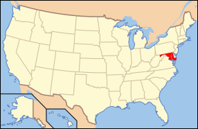
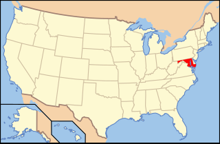
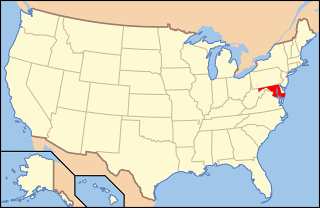
| 描述 | Map of USA with Maryland highlighted | ||||||||
| 日期 | see file history below. | ||||||||
| 來源 | 自己的作品 (Original text: own work by uploader, 我個人以下列物件為基礎來創作: Map of USA without state names.svg) | ||||||||
| 作者 |
This version: uploader Base versions this one is derived from: originally created by Wapcaplet |
||||||||
| 授權許可 (重用此檔案) |
此檔案採用創用CC 姓名標示 2.0 通用版授權條款。
|
||||||||
| 其他版本 | Map of USA with state names.svg | ||||||||
| SVG開發 |

檔案歷史
點選日期/時間以檢視該時間的檔案版本。
| 日期/時間 | 縮圖 | 尺寸 | 用戶 | 備註 | |
|---|---|---|---|---|---|
| 目前 | 2012年11月1日 (四) 13:42 | | 286 × 186(167 KB) | Kmusser(對話 | 貢獻) | remove VA portion of eastern shore |
| 2008年4月26日 (六) 09:06 |  | 286 × 186(167 KB) | Rub1615~commonswiki(對話 | 貢獻) | Reverted to version as of 07:11, 9 June 2006 | |
| 2008年4月23日 (三) 15:32 |  | 286 × 186(183 KB) | Rfc1394(對話 | 貢獻) | Add an inset to the map enlarging the focus area to make it easier to see the designated state. | |
| 2006年6月9日 (五) 07:11 |  | 286 × 186(167 KB) | Huebi~commonswiki(對話 | 貢獻) | {{Information| |Description=Map of USA with Maryland highlighted |other_versions=image:Map of USA with state names.svg }} Category:Maps of the United States Category:Maps of Maryland Category:SVG maps {{GFDL-en}}{{cc-by-2.0}}{{cc-by-sa- |
無法覆蓋此檔案。
檔案用途
下列11個頁面有用到此檔案:
- Locator maps for U.S. states
- Maryland
- File:Map of USA MD.svg
- File:Map of USA highlighting Maryland.png
- Category:Cities in Maryland
- Category:Kettering, Maryland
- Category:Locator maps of cities in Maryland
- Category:Maps of Catholic dioceses of Maryland
- Category:Maps of Maryland
- Category:Maryland
- Category:Videos from Maryland
全域檔案使用狀況
以下其他 wiki 使用了這個檔案:
- af.wikipedia.org 的使用狀況
- ang.wikipedia.org 的使用狀況
- an.wikipedia.org 的使用狀況
- arc.wikipedia.org 的使用狀況
- ar.wikipedia.org 的使用狀況
- arz.wikipedia.org 的使用狀況
- ay.wikipedia.org 的使用狀況
- az.wiktionary.org 的使用狀況
- bg.wikipedia.org 的使用狀況
- bi.wikipedia.org 的使用狀況
- bo.wikipedia.org 的使用狀況
- bpy.wikipedia.org 的使用狀況
- bxr.wikipedia.org 的使用狀況
- ca.wikipedia.org 的使用狀況
- ce.wikipedia.org 的使用狀況
- cs.wikipedia.org 的使用狀況
- da.wikipedia.org 的使用狀況
- Maryland
- Annapolis
- Baltimore
- Towson (Maryland)
- Worcester County (Maryland)
- Allegany County (Maryland)
- Anne Arundel County
- Denton (Maryland)
- Frederick (Maryland)
- Oakland (Maryland)
- Cumberland (Maryland)
- Sharpsburg (Maryland)
- Hagerstown (Maryland)
- La Plata (Maryland)
- Rockville (Maryland)
- Baltimore County
- Frederick County (Maryland)
檢視此檔案的更多全域使用狀況。