File:Map of USA with state names el.svg
Aller à la navigation
Aller à la recherche

Taille de cet aperçu PNG pour ce fichier SVG : 800 × 495 pixels. Autres résolutions : 320 × 198 pixels | 640 × 396 pixels | 1 024 × 633 pixels | 1 280 × 791 pixels | 2 560 × 1 583 pixels | 959 × 593 pixels.
Fichier d’origine (Fichier SVG, nominalement de 959 × 593 pixels, taille : 630 kio)
Légendes
Légendes
Ajoutez en une ligne la description de ce que représente ce fichier


.svg)


Historique du fichier
Cliquer sur une date et heure pour voir le fichier tel qu'il était à ce moment-là.
| Date et heure | Vignette | Dimensions | Utilisateur | Commentaire | |
|---|---|---|---|---|---|
| actuel | 31 mars 2008 à 05:32 | | 959 × 593 (630 kio) | Αντιγόνη (d | contributions) | Letters `d better be transformed to outlines due to current poor support of greek fonts in metawiki |
| 22 janvier 2008 à 13:13 |  | 959 × 593 (332 kio) | Hypnotist (d | contributions) | Τροποποίηση κάποιων ονομάτων | |
| 22 octobre 2007 à 22:08 |  | 959 × 593 (630 kio) | Αντιγόνη (d | contributions) | {{Information |Description= |Source= |Date= |Author= |Permission= |other_versions= }} | |
| 22 octobre 2007 à 21:50 |  | 959 × 593 (296 kio) | Αντιγόνη (d | contributions) | {{Information |Description= |Source= |Date= |Author= |Permission= |other_versions= }} | |
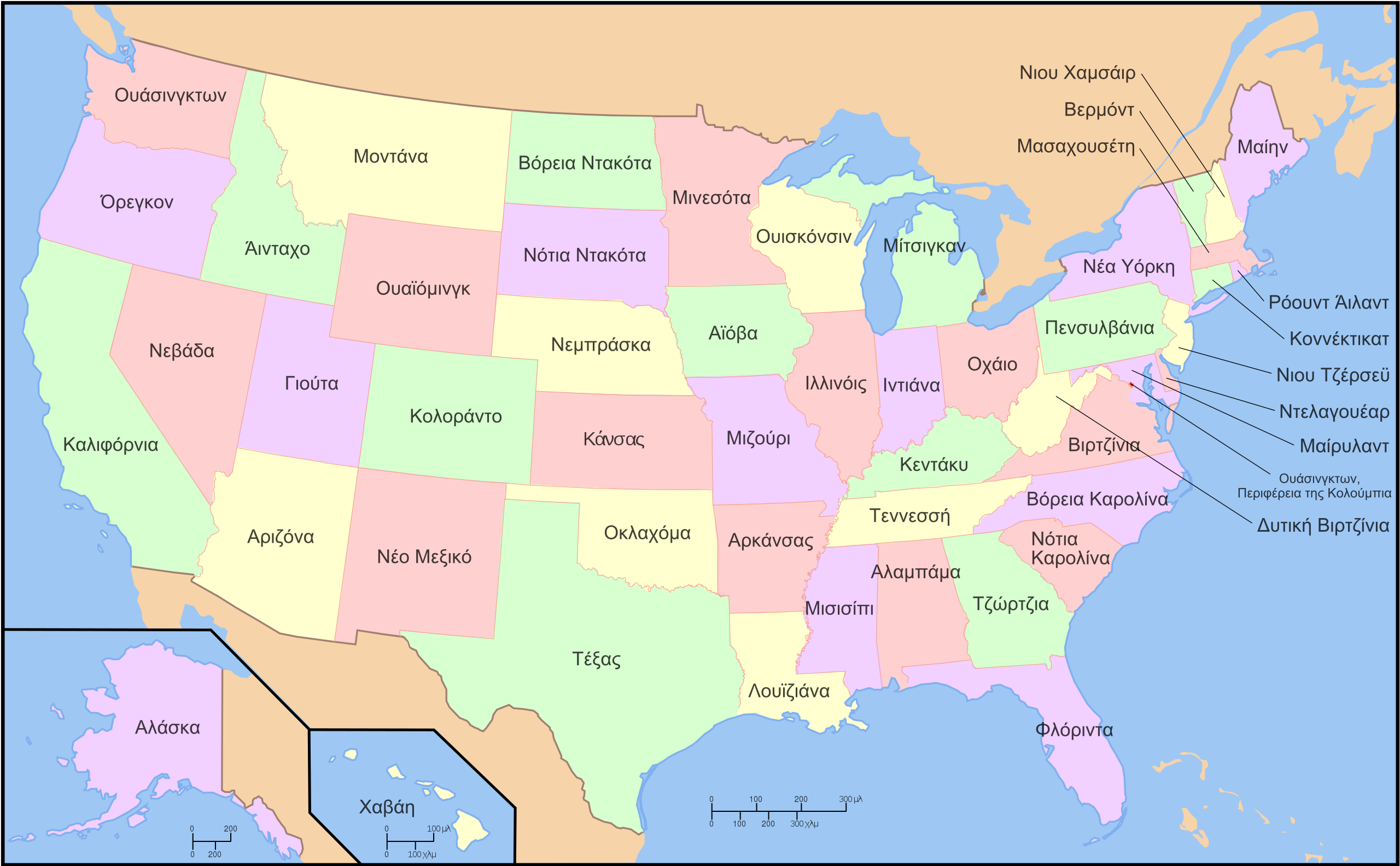
| 22 octobre 2007 à 21:36 |  | 959 × 593 (295 kio) | Αντιγόνη (d | contributions) | {{Information |Description={{en|A map of the United States, with state names (Greek labels)}} |Source= |Date=October 23, 2007 |Author=Antigoni |Permission= |other_versions= }} |
Vous ne pouvez pas remplacer ce fichier.
Utilisations locales du fichier
Les 48 pages suivantes utilisent ce fichier :
- File:EstatsEUA.png
- File:Map of USA showing state names in Persian.jpg
- File:Map of USA with state names.svg
- File:Map of USA with state names ar.svg
- File:Map of USA with state names as.svg
- File:Map of USA with state names bg.svg
- File:Map of USA with state names bn.svg
- File:Map of USA with state names bpy.svg
- File:Map of USA with state names bs.svg
- File:Map of USA with state names ce.svg
- File:Map of USA with state names chr.svg
- File:Map of USA with state names el.svg
- File:Map of USA with state names eo.svg
- File:Map of USA with state names es.svg
- File:Map of USA with state names et.svg
- File:Map of USA with state names eu.svg
- File:Map of USA with state names fa.svg
- File:Map of USA with state names fr.svg
- File:Map of USA with state names gl.svg
- File:Map of USA with state names grc.png
- File:Map of USA with state names haw.svg
- File:Map of USA with state names he.svg
- File:Map of USA with state names hi.png
- File:Map of USA with state names hi.svg
- File:Map of USA with state names hr.svg
- File:Map of USA with state names it.svg
- File:Map of USA with state names ka.png
- File:Map of USA with state names kk.png
- File:Map of USA with state names mk.svg
- File:Map of USA with state names mr.svg
- File:Map of USA with state names nv.svg
- File:Map of USA with state names pt.svg
- File:Map of USA with state names ru(2).svg
- File:Map of USA with state names ru.svg
- File:Map of USA with state names sco.svg
- File:Map of USA with state names sk.svg
- File:Map of USA with state names sr.svg
- File:Map of USA with state names sv.svg
- File:Map of USA with state names th.svg
- File:Map of USA with state names uk.svg
- File:Map of USA with state names ur.svg
- File:Map of USA with state names zh-hans.svg
- File:Map of USA with state names zh-hant.svg
- File:Ovtâstum staatâi uásistaatah smn.svg
- File:USA map with state names pl.svg
- File:USA map with state names szl.svg
- File:Yhdysvaltain osavaltiot.svg
- Template:Other versions/Map of USA with state names
Utilisations du fichier sur d’autres wikis
Les autres wikis suivants utilisent ce fichier :
- Utilisation sur el.wikipedia.org