File:Map of areas affected by 2021 European floods.svg
出典:ウィキメディア・コモンズ (Wikimedia Commons)
ナビゲーションに移動
検索に移動
この SVG ファイルのこの PNG プレビューのサイズ: 587 × 600 ピクセル. その他の解像度: 235 × 240 ピクセル | 470 × 480 ピクセル | 752 × 768 ピクセル | 1,002 × 1,024 ピクセル | 2,004 × 2,048 ピクセル | 593 × 606 ピクセル。
元のファイル (SVG ファイル、593 × 606 ピクセル、ファイルサイズ: 695キロバイト)
ファイル情報
構造化データ
キャプション
概要
[編集]解説Map of areas affected by 2021 European floods.svg |
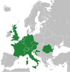
English: A map of the areas affected by the 2021 European Floods, derived from Blank map of Europe cropped.svg.
|
日付 | |
原典 | 投稿者自身による著作物 |
作者 | Isochrone |
その他のバージョン | |
SVG 開発 InfoField |
ライセンス
[編集]この作品の著作権者である私は、この作品を以下のライセンスで提供します。
This file is licensed under the Creative Commons Attribution-Share Alike Attribution-Share Alike 4.0 International, 3.0 Unported, 2.5 Generic, 2.0 Generic and 1.0 Generic license.
- あなたは以下の条件に従う場合に限り、自由に
- 共有 – 本作品を複製、頒布、展示、実演できます。
- 再構成 – 二次的著作物を作成できます。
- あなたの従うべき条件は以下の通りです。
- 表示 – あなたは適切なクレジットを表示し、ライセンスへのリンクを提供し、変更があったらその旨を示さなければなりません。これらは合理的であればどのような方法で行っても構いませんが、許諾者があなたやあなたの利用行為を支持していると示唆するような方法は除きます。
- 継承 – もしあなたがこの作品をリミックスしたり、改変したり、加工した場合には、あなたはあなたの貢献部分を元の作品とこれと同一または互換性があるライセンスの下に頒布しなければなりません。
ファイルの履歴
過去の版のファイルを表示するには、その版の日時をクリックしてください。
日付と時刻 | サムネイル | 寸法 | 利用者 | コメント | |
---|---|---|---|---|---|
現在の版 | 2022年12月27日 (火) 10:01 | 593 × 606 (695キロバイト) | Iktsokh (トーク | 投稿記録) | Correction of borders | |
2021年7月22日 (木) 08:57 | 593 × 606 (692キロバイト) | Isochrone (トーク | 投稿記録) | update | ||
2021年7月18日 (日) 14:12 | 593 × 606 (698キロバイト) | GPinkerton (トーク | 投稿記録) | Re-add France because there were also floods in France ([https://en.wikipedia.org/w/index.php?title=2021_European_floods&oldid=1034207380#France]). A more useful map would be by regions, there's no reason Sardinia, most of Great Britain, Northern Ireland, etc need to be here ... | ||
2021年7月18日 (日) 09:44 | 593 × 606 (692キロバイト) | Jurryaany (トーク | 投稿記録) | Added Austria | ||
2021年7月17日 (土) 18:28 | 593 × 606 (692キロバイト) | Isochrone (トーク | 投稿記録) | rm france | ||
2021年7月17日 (土) 13:47 | 593 × 606 (692キロバイト) | Isochrone (トーク | 投稿記録) | better colour | ||
2021年7月17日 (土) 13:40 | 593 × 606 (692キロバイト) | Isochrone (トーク | 投稿記録) | Uploaded own work with UploadWizard |
このファイルは上書きできません。
ファイルの使用状況
このファイルを使用しているページはありません。
グローバルなファイル使用状況
以下に挙げる他のウィキがこの画像を使っています:
- fr.wikipedia.org での使用状況
- ja.wikipedia.org での使用状況
- ne.wikipedia.org での使用状況
- pl.wikipedia.org での使用状況
- pt.wikipedia.org での使用状況
- ro.wikipedia.org での使用状況
- simple.wikipedia.org での使用状況
- tr.wikipedia.org での使用状況
メタデータ
このファイルには、追加情報があります (おそらく、作成やデジタル化する際に使用したデジタルカメラやスキャナーが追加したものです)。
このファイルが元の状態から変更されている場合、修正されたファイルを完全に反映していない項目がある場合があります。
画像の説明 | A blank Map of Europe. Every country has an id which is its ISO-3166-1-ALPHA2 code in lower case.
Members of the EU have a class="eu", countries in europe (which I found turkey to be but russia not) have a class="europe". Certain countries are further subdivided the United Kingdom has gb-gbn for Great Britain and gb-nir for Northern Ireland. Russia is divided into ru-kgd for the Kaliningrad Oblast and ru-main for the Main body of Russia. There is the additional grouping #xb for the "British Islands" (the UK with its Crown Dependencies - Jersey, Guernsey and the Isle of Man) and the Kingdom of Denmark (Denmark, Faroe Islands, Greenland) Contributors. Original Image: (http://commons.wikimedia.org/wiki/Image:Europe_countries.svg) Júlio Reis (http://commons.wikimedia.org/wiki/User:Tintazul). Recolouring and tagging with country codes: Marian "maix" Sigler (http://commons.wikimedia.org/wiki/User:Maix) Improved geographical features: http://commons.wikimedia.org/wiki/User:W!B: Updated to reflect dissolution of Serbia & Montenegro: http://commons.wikimedia.org/wiki/User:Zirland Updated to include British Crown Dependencies as seperate entities and regroup them as "British Islands", with some simplifications to the XML and CSS: James Hardy (http://commons.wikimedia.org/wiki/User:MrWeeble) Validated (http://commons.wikimedia.org/wiki/User:CarolSpears) Changed the country code of Serbia to RS per http://en.wikipedia.org/wiki/Serbian_country_codes and the file http://www.iso.org/iso/iso3166_en_code_lists.txt (http://commons.wikimedia.org/wiki/User:TimothyBourke) Uploaded on behalf of User:Checkit, direct complaints to him plox: 'Moved countries out of the "outlines" group, removed "outlines" style class, remove separate style information for Russia' (http://commons.wikimedia.org/wiki/User:Collard) Updated various coastlines and boarders and added various islands not previously shown (details follow). Added Kosovo, Northern Cyprus, Crimea, Abkhazia, South Ossetia, Transnistria and Nagorno-Karabakh as disputed territories. Moved major lakes to their own object and added more. List of updated boarders/coastlines: British Isles (+ added Isle of Wight, Skye, various smaller islands), the Netherlands, Germany, Austria, Hungary, Czech Republic, Denmark, Sweden, Finland, Poland, Kaliningrad Oblast of the Russian Federation (and minor tweaks to Lithuania), Estonia, Ukraine, Moldova (minor), Romania, Bulgaria, Turkey, Greece, F.Y.R. Macedonia, Serbia, Bosnia and Herzegovina, Montenegro, Albania, Croatia, Italy (mainland and Sicily), Malta (http://commons.wikimedia.org/wiki/User:Alphathon). Added Bornholm (http://commons.wikimedia.org/wiki/User:Heb)Released under CreativeCommons Attribution ShareAlike (http://creativecommons.org/licenses/by-sa/2.5/). |
---|---|
画像の幅 | 593 |
画像の高さ | 606 |